
Hebron, South Hebron Hills
08:30-13:00
Hebron
The Palestinian children are in the streets; it’s exam time. Netting has been added to the checkpoint next to Beit HaMeriva. The excavation at Tel Rumeida is being greatly enlarged; it now extends almost to the Palestinian home below that of the Abu Heikhal family.
Yesterday settlers lit a bonfire below Isa’s house. The Palestinian residents of Tel Rumeida are evaluating the damage.
South Hebron Hills
On both sides of the road the women of Palestine are bundling the harvest into sheaves.
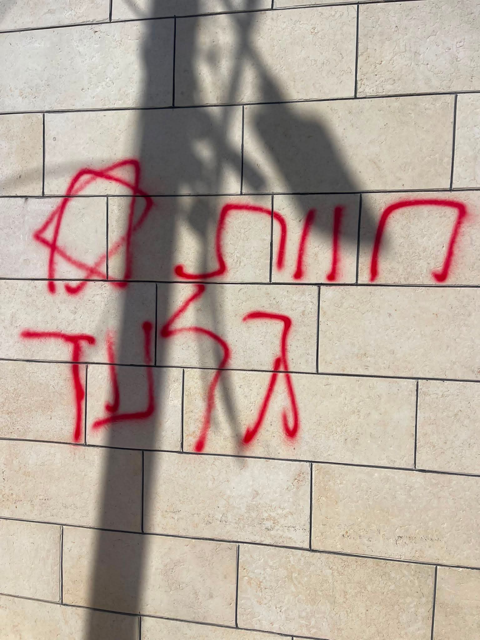
Yesterday we read the following story (cf. the link):
http://www.nrg.co.il/online/1/ART2/579/880.html?hp=1&cat=402
“Swastikas and PLO flags were discovered this morning (Sunday) on the walls of the ancient synagogue in Samua. Participants in a special trip to the location were shocked to find the site desecrated and hateful graffiti sprayed on the walls. The trip commemorated the 80th anniversary of the inauguration of excavations at the site of the ancient synagogue; it was organized by Herzog College and the Soussiya Field School. Some 200 of the 350 conference participants visited the synagogue to view the unique structure and understand its significance to the history of the Jewish people in the area.”
We went to Samua to see for ourselves. Samua is located in Palestinian territory; red signs warn Israeli citizens against entering the area. The archaeological site is located in the center of town, adjoining the mosque.
Yesterday, in fact, five buses with settlers came there, escorted by some 200 soldiers. The visit had been coordinated with the Palestinian Authority. Three years ago the Authority fenced the entire archaeological site, locked the gates and placed a guard. We saw Palestinian flags flying from Palestinian homes nearby, not on the site. A small swastika had been drawn on one of the stones in the rubble outside the fence.
We spoke to a very old Palestinian who told us his house, which had two storeys, was destroyed in the Six Day War, in 1967. It had been adjacent to the site; since then he hasn’t been permitted to rebuild it. We saw no hate crimes or abusive graffiti. The struggle over the “narrative” – who had been there first – is the motivation for the story. No one cares about protecting the human rights of an actual living and breathing person.
His Palestinian attorney told him the Palestinian Authority wants to turn it into a tourist site.
Another of the occupation’s wonders…
Hebron
See all reports for this place-
According to Wye Plantation Accords (1997), Hebron is divided in two: H1 is under Palestinian Authority control, H2 is under Israeli control. In Hebron there are 170,000 Palestinian citizens, 60,000 of them in H2. Between the two areas are permanent checkpoints, manned at all hours, preventing Palestinian movement between them and controlling passage of permit holders such as teachers and schoolchildren. Some 800 Jews live in Avraham Avinu Quarter and Tel Rumeida, on Givat HaAvot and in the wholesale market.
Checkpoints observed in H2:
- Bet Hameriva CP- manned with a pillbox
- Kapisha quarter CP (the northern side of Zion axis) - manned with a pillbox
- The 160 turn CP (the southern side of Zion axis) - manned with a pillbox
- Avraham Avinu quarter - watch station
- The pharmacy CP - checking inside a caravan with a magnometer
- Tarpat (1929) CP - checking inside a caravan with a magnometer
- Tel Rumeida CP - guarding station
- Beit Hadassah CP - guarding station
Three checkpoints around the Tomb of the Patriarchs
 Muhammad D.May-13-2026Hebron - Request for compensation for land expropriation
-
South Hebron Hills
See all reports for this place-
South Hebron Hills
South Hebron Hills is a large area in the West Bank's southern part.
Yatta is a major city in this area: right in the border zone between the fertile region of Hebron and its surroundings and the desert of the Hebron Hills. Yatta has about 64,000 inhabitants.
The surrounding villages are called Masafer Yatta (Yatta's daughter villages). Their inhabitants subsist on livestock and agriculture. Agriculture is possible only in small plots, especially near streams. Most of the area consists of rocky terraces.Since the beginning of the 1980s, many settlements have been established on the agricultural land cultivated by the Palestinians in the South Hebron Hills region: Carmel, Maon, Susia, Masadot Yehuda, Othniel, and more. Since the settlements were established and Palestinians cultivation areas have been reduced; the residents of the South Hebron Hills have been suffering from harassment by the settlers. Attempts to evict and demolish houses have continued, along with withholding water and electricity. The military and police usually refrain from intervening in violent incidents between settlers and Palestinians do not enforce the law when it comes to the investigation of extensive violent Jewish settlers. The harassment in the South Hebron Hills includes attacking and attempting to burn residential tents, harassing dogs, harming herds, and preventing access to pastures.
There are several checkpoints in the South Hebron Hills, on Routes 317 and 60. In most of them, no military presence is apparent, but rather an array of pillboxes monitor the villages. Roadblocks are frequently set up according to the settlers and the army's needs. These are located at the Zif Junction, the Dura-al Fawwar crossing, and the Sheep Junction at the southern entrance to Hebron.
Updated April 2022
 A Palestinian residentJul-19-2026Graffiti sprayed in A-Tuwani
-