
‘Awarta, ‘Einabus, Huwwara, Jama’in, Kifl Harith, Qira, Shomron Crossing, Za’tara (Tapuah)
9:20, We entered the territories through the Shomron crossing. At the junction to Kifl Harith there was a military vehicle, but we didn't see any activity near it.
Za'tra (Tapuach Junction) The parkink lot is empty of any vehicles; in the tower there was one soldier; there were four soldiers at the bus stop on the road to Ramallah.
In the town Huwarra it was business as usual. We saw nothing out of the ordinary.
At Huwwara CP a military jeep entered the parking lot; there were soldiers in the tower, but the road into and out of Nablus was open and the traffic was moving freely.
We drove into Awarta and stopped at a small shop to talk with someone Nadim was friendly with. We asked him about the current situation with the settlers. They throw stones sometimes at the checkpoints into Nablus. The previous evening the army had gone into two houses in Burin. He had only heard about it, but didn't know any details. In the Salfit area a settler ran over a Palestinian. Our friend did not know how badly he was hurt. The settlers from Itamar don't come into Awarta, but if a Palestinian from Awarta goes to work his own land that is close to Itamar, he is attacked and chased away. The whole list of events was related to us in a very matter of fact way. This is what is; nothing out of the ordinary.
Back in the town, Huwarra, as we ate falafel a friend told us the events of the previous day, Wednesday, November 19. At 17:00, in the late afternoon, the army entered the town with a number of vehicles and declared a curfew, immediately. All the stores had to close and the people had to be in their houses. The reason given was that a stone had been thrown at a settler's car and a Molotov cocktail had been thrown at a settlers' bus. It was not clear when this had happened; it was assumed that the incident happened the previous evening. The curfew was in effect all night.
We went through Einabous, Jamain and Qira. Everything seemed very quiet. At the junction of Ariel and Haris we saw a large military vehicle, perhaps the same one that had been there when we entered, and a police car. We slowed down to see what was happening. The military vehicle was obviously stuck and was being connected to the police car to be towed. That happens also.
We left by way of the Shomron crossing.
'Awarta
See all reports for this place-
Awarta, an internal checkpoint in the heart of the West Bank, is located east of the Hawara checkpoint, at the junction of Roads 555 (which was forbidden for Palestinian traffic in this area) and the entrance road to Nablus. It was one of the four checkpoints that surrounded Nablus until 2009. We used to watch it at Huwwara shifts because it was the only one where goods could be transferred to and from Nablus, using the back-to-back method. It was operated by the army, from 06:00 to 20:00. Until 2009.
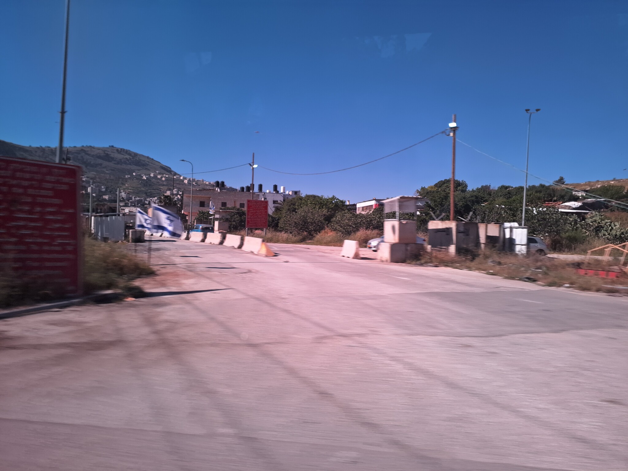 Ronit Dahan-RamatiApr-23-2026Awarta Checkpoint is empty
-
'Einabus
See all reports for this place-
'Einabus
A village in the Nablus district, west of Hawara, numbering about 3,000 people. 85% of the village's land in Area B, 15% in Area C. 114 dunams of its land were expropriated to establish the violent settlement of Yitzhar and its outposts. Due to the proximity and violence of the settlers sitting on the top of the mountain to invade the village lands, the inhabitants of Einabus regularly suffer from harassment by settlers throwing stones, smashing windows, cutting down olive groves, as well as arson of vehicles and fields. All these were intensified in the second decade of the 21st century.
-
Huwwara
See all reports for this place-
The Huwwara checkpoint is an internal checkpoint south of the city of Nablus, at the intersection of Roads 60 and 5077 (between the settlements of Bracha and Itamar). This checkpoint was one of the four permanent checkpoints that closed on Nablus (Beit Furik and Awarta checkpoints to the east and the Beit Iba checkpoint to the west). It was a pedestrian-only barrier. As MachsomWatch volunteers, we watched therre since 2001 two shifts a day - morning and noon, the thousands of Palestinians leaving Nablus and waiting for hours in queues to reach anywhere else in the West Bank, from the other side of the checkpoint the destination could only be reached by public transport. In early June 2009, as part of the easing of Palestinian traffic in the West Bank, the checkpoint was opened to vehicular traffic. The passage was free, with occasional military presence in the guard tower. Also, there were vehicle inspections from time to time. Since the massacre on 7.10.2023, the checkpoint has been closed to Palestinians.
On February 26, 2023, about 400 settlers attacked the town's residents for 5 hours and set fire to property, such as houses and cars. Disturbances occurred in response to a shooting of two Jewish residents of Har Bracha by a Palestinian Terrorist. The soldiers stationed in the town did not prevent the arson and rescued Palestinian families from their homes only after they were set on fire. No one was punished and Finance Minister Smotrich stated that "the State of Israel should wipe out Hawara." Left and center organizations organized solidarity demonstrations and support actions for the residents of Hawara.Hawara continued to be in the headlines in all the months that followed: more pogroms by the settlers, attacks by Palestinians and a massive presence of the army in the town. It amounted to a de facto curfew of commerce and life in the center of the city. On October 5, 2023, MK Zvi established a Sukkah in the center of Hawara and hundreds of settlers backed the army blocked the main road and held prayers in the heart of the town all night and the next day. On Saturday, October 7, 23 The "Swords of Iron" war began with an attack by Hamas on settlements surrounding Gaza in the face of a poor presence of the IDF. Much criticism has been made of the withdrawal of military forces from the area surrounding Gaza and their placement in the West Bank, and in the Hawara and Samaria region in particular, as a shield for the settlers who were taking over and rioting.
On November 12, 2023, the first section of the Hawara bypass road intended for Israeli traffic only was opened. In this way, the settlers can bypass the road that goes through the center of Hawara, which is the main artery for traffic from the Nablus area to Ramallah and the south of the West Bank. For the construction of the road, the Civil Administration expropriated 406 dunams of private land belonging to Palestinians from the nearby villages. The settlers are not satisfied with this at the moment, and demand to also travel through Hawara itself in order to demonstrate presence and control.(updated November 2023)
. Shoshi AnbarMay-18-2025Huwara: The old houses in Area C
-
Jamma'in*
See all reports for this place-
Jamma'in*
Jamma'in is a small town, with some of the best quarries in the area. The stone is sold all over Palestine and Israel and even outside the country. The city also has an industrial area. Although they are close to the Ariel and Tapuach settlements, Jama'in farmers have no daily problems with settlers. Harassment occurs mainly during the October harvest season - the settlers sometimes try to drive the farmers out of their plots. Jama'in has its own info-icon water reservoir tower. The water is obtained from sources and paid for by the Palestinian Authority. The city has one clinic that opens only 2-3 days a week. The biggest problem is that there is only one hospital in Nablus in an area of about 10,000 residents. This hospital is too small, does not have enough equipment, and not enough doctors.
Zeita / jama'in is a village of about 3000 inhabitants near Jama'in and Ariel. In the 1980s, land was taken from the village and transferred to settlements. Farmers in the village have lost some of their income. The settlements are located on the ridges, further away from Zeita, which is in the valley. The village does not often suffer from harassment.
The water sources for Zeita and Jama'in that have supplied water to the villages for centuries have been confiscated by the Mekorot company and the water is flowed to Ariel. Without a reasonable info-icon water supply the villages cannot develop agriculture or any industry.
The electricity comes from the Israeli Electric Company through Ariel and Jama'in.
The IDF oversees the main roads and entrances to the villages. -
Jama'in is a small town, with some of the best quarries in the area. The stone is sold all over Palestine and Israel and even outside the country. The city also has an industrial area. Although they are close to the Ariel and Tapuach settlements, Jama'in farmers have no daily problems with settlers. Harassment occurs mainly during the October harvest season - the settlers sometimes try to drive the farmers out of their plots. Jama'in has its own info-icon water reservoir tower. The water is obtained from sources and paid for by the Palestinian Authority. The city has one clinic that opens only 2-3 days a week. The biggest problem is that there is only one hospital in Nablus in an area of about 10,000 residents. This hospital is too small, does not have enough equipment, and not enough doctors. Zeita is a village of about 3000 inhabitants near Jama'in and Ariel. In the 1980s, land was taken from the village and transferred to settlements. Farmers in the village have lost some of their income. The settlements are located on the ridges, further away from Zeita, which is in the valley. The village does not often suffer from harassment. The water sources for Zeita and Jama'in that have supplied water to the villages for centuries have been confiscated by the Mekorot company and the water is flowed to Ariel. Without a reasonable info-icon water supply the villages cannot develop agriculture or any industry. The electricity comes from the Israeli Electric Company through Ariel and Jama'in. The IDF oversees the main roads and entrances to the villages.
-
Kifl Harith
See all reports for this place-
Kifl Harith
This is a Palestinian located north-west of the settler-colony town of Ariel, 18 kilometers south of the city of Nablus. It numbers 3, 206 inhabitants, as of 2007. 42% of the village lands lie in Area B, and 58% in Area C. In 1978, some hundreds of dunams of the village’s farmland was sequestered in order to found the settler-colony of Ariel – in total 5,184 dunams from the Palestinian communities of Salfit, Iscaqa, Marda, and Kifl Harith. Dozens of square kilometers were also confiscated for paving road no. 5 as well as road 505 and their buffer zones, and the Israeli electricity company’s power station. Over the years the village has suffered harassment by sometimes-armed settler-colonists, even casualties. In 1968 the army’s rabbinate ruled the maqam site Nabi Yanoun (sanctified grave of the Prophet Yanoun) is in fact the tomb of Joshua, Son of Nun. Another structure in the village, named Nabi Tul Kifl by the Palestinians, has been identified by the Israeli authorities as to the tomb of Caleb, Son of Yefuneh. These sites are located in the heart of the village, near the mosque, and at times of Jewish religious festivities and pilgrimages, the center of the village is illuminated by projectors and thousands of Jews arrive, protected by hundreds of Israeli soldiers. During such a period, a night curfew is imposed on the village and the villagers are forced to stay shut inside their homes.
-
Qira
See all reports for this place-
Qira
This village is located in the Salfit district of the northern West Bank, 19 kilometers south-west of Nablus. The village population numbered 1,387 as of 2016. 97.6% of the village lands are categorized as Area B, whereas the 2.3% remaining are in Area C. The Separation Fence erected around the settler-colony city of Ariel separates Qira from its local town Salfit, and necessitates a detour of about 20 kilometers.
In 2010-2015, the women’s center in the village held meetings and workshops shared by the village women and children with members of MachsomWatch.
For further information: http://vprofile.arij.org/salfit/pdfs/vprofile/Qira_vp_en.pdf
-
Shomron Crossing
See all reports for this place-
Shomron Crossing The Shomron checkpoint for vehicles. is located east of Rosh HaAyin and Kafr Qassem, on Road 5 (Trans-Samaria) leading to Ariel and the Za'atara junction. It is intended for blue ID cardholders, foreign guests or diplomats, and international organizations only. In 2009 the management was entrusted to a civil security company.
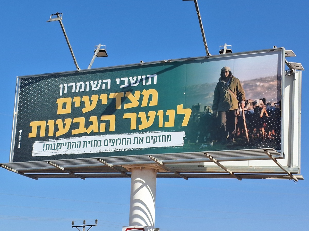 Ronit Dahan-RamatiAug-21-2025Highway 505: Salute to the Hilltop Youth
-
Za'tara (Tapuah)
See all reports for this place-
Za'tara (Tapuah) Za'tara is an internal checkpoint in the heart of the West Bank, at the intersection of Road 60 and Road 505 (Trans-Samaria), east of the Tapuah settlement. This checkpoint is the "border" marked by the IDF between the north and south of the West Bank, in accordance with the policy of separation between the two parts of the West Bank that has been in place since December 2005. At the Za'tara checkpoint, there are separate routes for Israelis and Palestinians. In the route for Israelis, there are no inspections and the route for Palestinians inspects. The queue lengthens and shortens suits. The checkpoint is open 24 hours a day. The checkpoint is partially staffed and the people who pass through it are checked at random.
 Ronit Dahan-RamatiJun-9-2026Za'atara (Tapuach Junction). The Temple Flag Above a Station
-
