
South Hebron Hills
South Hebron Hills and Hebron Tuesday morning 23 November 2004Watchers: Hagit B (reporting in Hebrew) Elena L (English)We left Shoket Junction at 6:30 and retuned at 10:45Summary : Cold and muddy; hardly anyone about apart from children walking to school. The pillboxes are manned as usual.Route 60 –route 35Sansana – open; Al Fawwar – open; Sheep’s Crossing – a Humvee present. The soldiers did not detain anyone when we were there. The Shiyukh-Hebron crossing is open and there are almost no taxis about – only the little girls crossing route 60 on their way to school; East Halhul –Sa’ir: open in the direction of Halhul. The “Humanitarian” CP (Ras al Jura; passage for ambulances and medical materiel) was closed . A military jeep stood there, but there were no cars waiting to go through. The Halhul –Hebron bridge was open and so was the ascent to it from route 35. The glass workshop on the bridge was open and the owner told us of the general sense of despair with people staying at home because there is no work to be had. The tall house opposite has been requisitioned by the army for the last 4 years and the glassmaker said that the family who owns the house and lives on the its first floor have lost hope of recovering it. Idhna CP- was open. A BP jeep stood there. There was very little traffic in general and very few taxis on route 60. a taxi-driver at Shiyukh was collecting passengers for Ramallah (only one got into his taxi while we were there) and he told us that to get to Ramallah, he had to make an enormous detour, avoiding route 60- the apartheid road [for Jewish settlers only]. His taxi was, indeed, stationed behind the dirt and cement-block barrier through which only pedestrians could pass from Shiyukh in order to get to route 60. In short, everything was pretty routine and very quiet and one can’t help asking oneself –where is everybody? Everything looks so ‘conquered’, so under control, including, apparently, the Palestinians’ inner anger.Hebron Since we were with S, our regular driver’s son, and not in our usual minibus, which sports an MW flag, we were allowed into Kiryat Arba. (Earlier attempts had been foiled when the guards at the gates had identified the MW flag and had then invented all sorts of excuses to bar our way). We crossed Kiryat Arba towards the Tomb of the Patriarchs (Cave of Machpela). The road between Kiryat Arba and the Machpela Cave is forbidden to Palestinian cars, despite the fact that it traverses Palestinian neighbourhoods. All along the road are shuttered shops and workshops and the entire street is empty of traffic – as if no one lived there any more. We parked the minibus opposite the Machpela cave. The Palestinians who come to pray there approach from another direction; so we did not see any of them. In the square there were two Palestinian souvenir shops that were open. There was also an assembly room and a shop selling Beit El tefillin [Orthodox Jewish ritual prayer accessories]. All the other houses and shops in the square seemed to have been abandoned. A military CP near the parking space was manned by two bored-looking soldiers. From the square we continued on foot. The road running from the square into the Jewish quarter is almost completely uninhabited – on only three or four first -floor verandas were there any signs of life. All the shops below were shuttered and locked. A soldier manning a CP in the road said that only school teachers on their way to school in the morning and the handful of families who still live in the road are allowed to use it (on foot). On the shuttered doors there is a plethora of Kahanist grafitti. This road (Shuhada St) leading to Beit Romano (in the heart of the Jewish quarter) and on to Beit Hadassa has in fact been taken over from the Palestinians who once lived and worked here. This is what the army calls in Orwellese a “secured” pathway. No fewer than six CPs have been placed around the Jewish quarter. Near Beit Romano is the Nahal company’s base and the motto on the large company sign outside reads: “Killers on sea and land”. We continued as far as Gross [traffic] Circle (Kikar Gross) but did not go on to Beit Hadassa , since we rather feared confrontations with women such as the Blue and White brigade. But we were told by the soldiers at Beit Romano CP that there were two more CPs on the road to Beit Hadassa . The CP at Beit Romano separates the Jewish quarter from the area known as H1, which is forbidden to Israelis. From the CP one can see the entrance into the Palestinian market , which, as a soldier told us, “hardly exists any more”. We saw a lone Palestinian lad with his few wares on a wheelbarrow disappearing into the market passageway.One of the soldiers pointed out to us the knocked-down ruins of the house whence came the sniper’s shot which killed an infant [Jewish] girl, Shalhevet Paz. Above this high point on the hill opposite the Jewish quarter the army has built an enormous observation post in order to deter other snipers. All the soldiers we spoke to knew about the “Breakers of the Silence” [Hebrew: shovrim sh’tikah; grass-roots organization of IDF vets who have gone to the press with descriptions of their service in the Territories] and declared to us that they would never do things like that. They were very bored and were clearly pleased to talk. Two of them wanted a detailed explanation of the aims of MW – and we obliged. Everything was so quiet. Not only the cold made us shiver.
Halhul-Hebron Bridge
See all reports for this place-
Generally allows free flowing traffic, except for sudden checks by soldiers stationed permanently in the pillbox, on Route 35 in the southern West Bank.
-
Hebron
See all reports for this place-
According to Wye Plantation Accords (1997), Hebron is divided in two: H1 is under Palestinian Authority control, H2 is under Israeli control. In Hebron there are 170,000 Palestinian citizens, 60,000 of them in H2. Between the two areas are permanent checkpoints, manned at all hours, preventing Palestinian movement between them and controlling passage of permit holders such as teachers and schoolchildren. Some 800 Jews live in Avraham Avinu Quarter and Tel Rumeida, on Givat HaAvot and in the wholesale market.
Checkpoints observed in H2:
- Bet Hameriva CP- manned with a pillbox
- Kapisha quarter CP (the northern side of Zion axis) - manned with a pillbox
- The 160 turn CP (the southern side of Zion axis) - manned with a pillbox
- Avraham Avinu quarter - watch station
- The pharmacy CP - checking inside a caravan with a magnometer
- Tarpat (1929) CP - checking inside a caravan with a magnometer
- Tel Rumeida CP - guarding station
- Beit Hadassah CP - guarding station
Three checkpoints around the Tomb of the Patriarchs
 Muhammad D.May-13-2026Hebron - Request for compensation for land expropriation
-
Sa'ir
See all reports for this place-
A relatively affluent suburb of Palestinian Hebron. West of Highway 60 leading from Bethlehem to Hebron. The entrance to Highway 60 and to Shuyukh and Beit Einun to the east is open, but is subject to changes - concrete blocks denying passage are stationed according to the needs of the army.
-
South Hebron Hills
See all reports for this place-
South Hebron Hills
South Hebron Hills is a large area in the West Bank's southern part.
Yatta is a major city in this area: right in the border zone between the fertile region of Hebron and its surroundings and the desert of the Hebron Hills. Yatta has about 64,000 inhabitants.
The surrounding villages are called Masafer Yatta (Yatta's daughter villages). Their inhabitants subsist on livestock and agriculture. Agriculture is possible only in small plots, especially near streams. Most of the area consists of rocky terraces.Since the beginning of the 1980s, many settlements have been established on the agricultural land cultivated by the Palestinians in the South Hebron Hills region: Carmel, Maon, Susia, Masadot Yehuda, Othniel, and more. Since the settlements were established and Palestinians cultivation areas have been reduced; the residents of the South Hebron Hills have been suffering from harassment by the settlers. Attempts to evict and demolish houses have continued, along with withholding water and electricity. The military and police usually refrain from intervening in violent incidents between settlers and Palestinians do not enforce the law when it comes to the investigation of extensive violent Jewish settlers. The harassment in the South Hebron Hills includes attacking and attempting to burn residential tents, harassing dogs, harming herds, and preventing access to pastures.
There are several checkpoints in the South Hebron Hills, on Routes 317 and 60. In most of them, no military presence is apparent, but rather an array of pillboxes monitor the villages. Roadblocks are frequently set up according to the settlers and the army's needs. These are located at the Zif Junction, the Dura-al Fawwar crossing, and the Sheep Junction at the southern entrance to Hebron.
Updated April 2022
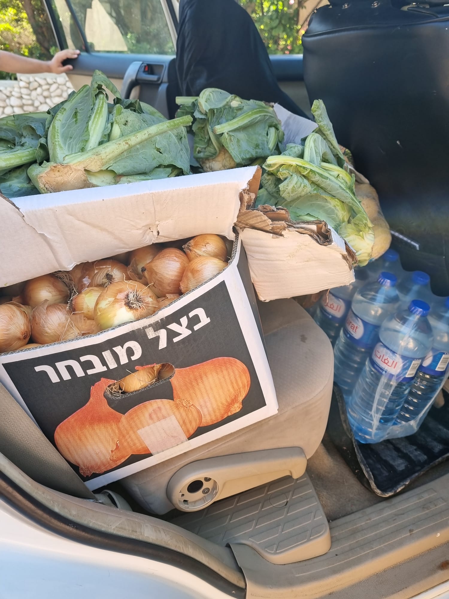 Muhammad D.Jul-1-2026From the food we brought to the Daramin family in the village of Khirbet al-Kharaba
-