South Hebron Hills - Settlers prevent olive harvest
At the Meitar checkpoint, there are almost no workers going to work, since most of them pass through the Tarqumiya checkpoint.
The road to Dahariya is closed, and a tractor repeatedly blocks the entrances to Ramadin and Dahariya.
In the Zanuta area, Yinon Levi’s vineyard is starting to look green, and settlers are also working there.
Abu Salah, who used to live in Zanuta and has olive trees there, cannot enter the area to harvest. According to him, Yinon Levi’s cows eat the olives.
He currently lives near Shweika, after being forced to leave his home and land, and he feels great sorrow over being displaced.
Abu Salah also reports on a new vineyard established on Palestinian land between Asa’el and Simiya, located between Highway 60 and Highway 317. It is not visible from the road.
Rania from Fuqiqis says that she has not been home for two years and has not visited her parents and siblings for fear that she will not be allowed to return home if she leaves the village.
According to her, sewage from the Negohot settlement passes near her parents’ house, and they fear diseases and damage to their health as a result.
Her family also has olive trees in the area, but they cannot reach or harvest them.
Location Description
Fuqeiqis
See all reports for this place-
Fuqeiqis
The village is located in Area C west of Khursa, road 3265. Its inhabitants make a living by raising sheep and farming. Negohot settlement was established west of the village. The settlement is expanding Negohot settlers harassing the villagers in many ways. Expansion of settlements is carried out without interruption on the lands of the village.
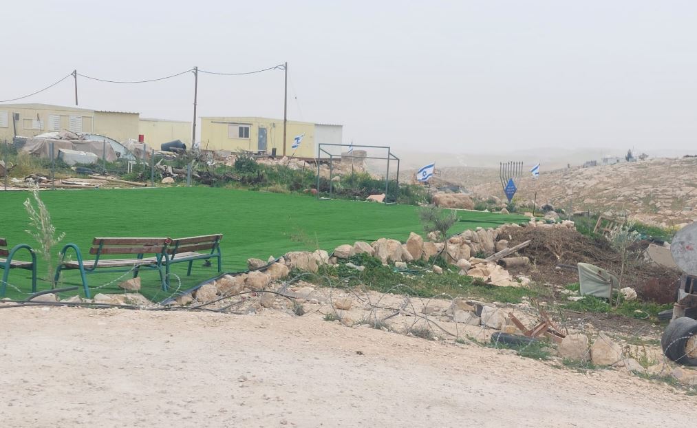 Michal TsadikFeb-17-2026Umm al-Khair: The soccer field for Palestinian children is surrounded by new trailers and lots of Israeli flags
-
Shweika
See all reports for this place-
Shweika
The checkpoint is located north of the Palestinian city of Shweika. In this area, the separation barrier was built east of the Green Line, for no apparent reason. There is no settlement there that should be in succession with the State of Israel.
But ... there is a single house that belongs to a Palestinian family. The separation barrier cut off the house and its occupants from the Palestinian settlement and left them in the seam area. That is, between the fence and the West Bank.
The residents of the house are supposed to manage their lives in connection with the settlements in the West Bank. They are not allowed to move within the State of Israel. In order to reach the West Bank, they need a permit and soldiers to open the checkpoint for them ...
One more catch...
-
South Hebron Hills
See all reports for this place-
South Hebron Hills
South Hebron Hills is a large area in the West Bank's southern part.
Yatta is a major city in this area: right in the border zone between the fertile region of Hebron and its surroundings and the desert of the Hebron Hills. Yatta has about 64,000 inhabitants.
The surrounding villages are called Masafer Yatta (Yatta's daughter villages). Their inhabitants subsist on livestock and agriculture. Agriculture is possible only in small plots, especially near streams. Most of the area consists of rocky terraces.Since the beginning of the 1980s, many settlements have been established on the agricultural land cultivated by the Palestinians in the South Hebron Hills region: Carmel, Maon, Susia, Masadot Yehuda, Othniel, and more. Since the settlements were established and Palestinians cultivation areas have been reduced; the residents of the South Hebron Hills have been suffering from harassment by the settlers. Attempts to evict and demolish houses have continued, along with withholding water and electricity. The military and police usually refrain from intervening in violent incidents between settlers and Palestinians do not enforce the law when it comes to the investigation of extensive violent Jewish settlers. The harassment in the South Hebron Hills includes attacking and attempting to burn residential tents, harassing dogs, harming herds, and preventing access to pastures.
There are several checkpoints in the South Hebron Hills, on Routes 317 and 60. In most of them, no military presence is apparent, but rather an array of pillboxes monitor the villages. Roadblocks are frequently set up according to the settlers and the army's needs. These are located at the Zif Junction, the Dura-al Fawwar crossing, and the Sheep Junction at the southern entrance to Hebron.
Updated April 2022
Michal TsadikFeb-17-2026Umm al-Khair: The soccer field for Palestinian children is surrounded by new trailers and lots of Israeli flags
-
Zanuta
See all reports for this place-
Zanuta was a small rural Palestinian locality until its demolition. It was situated in the space around the town Dahariya in the South Hebron Hills, about a ten-minute ride from Meitar Checkpoint. There are documented remains of a large Byzantine settlement in the area. Since the Ottoman (Turkish Empire) period (1516-1917) Zanuta was documented as a locality of shepherds and farmers who live in the remains of the ancient structures and the residential caves near them.
Two individual ranches of colonists were created next to Zanuta: Meitarim (of the colonist Yinon Levi) to the east, and Yehudah (of the colonist Elyashiv Nachum) to the north. Endless attacks, harassments and attempt to chase away the Zanuta villagers have originated in these two outposts.
Until the expulsion, four families lived in the village: A-Samama, Al-Tel, Al Batat, and Al-Qaisia. Farming constituted their main economic activity and employed most of the villagers. The total area of the village is about 12,000 dunams, of which about 3,000 are tended, mostly with field crops.
This village has never had a master plan that would legitimize construction permits. The Civil Administration claimed it was too small and the distance to the next town, Dahariya, too great. For this reason, the Israeli authorities pressured the villagers to leave. The colonists did the job for them.
-