ח'לת אל-מופתי - הצבא ועצר שלושה בני משפחה שמתנחלים פלשו לאדמותיהם
כביש 60
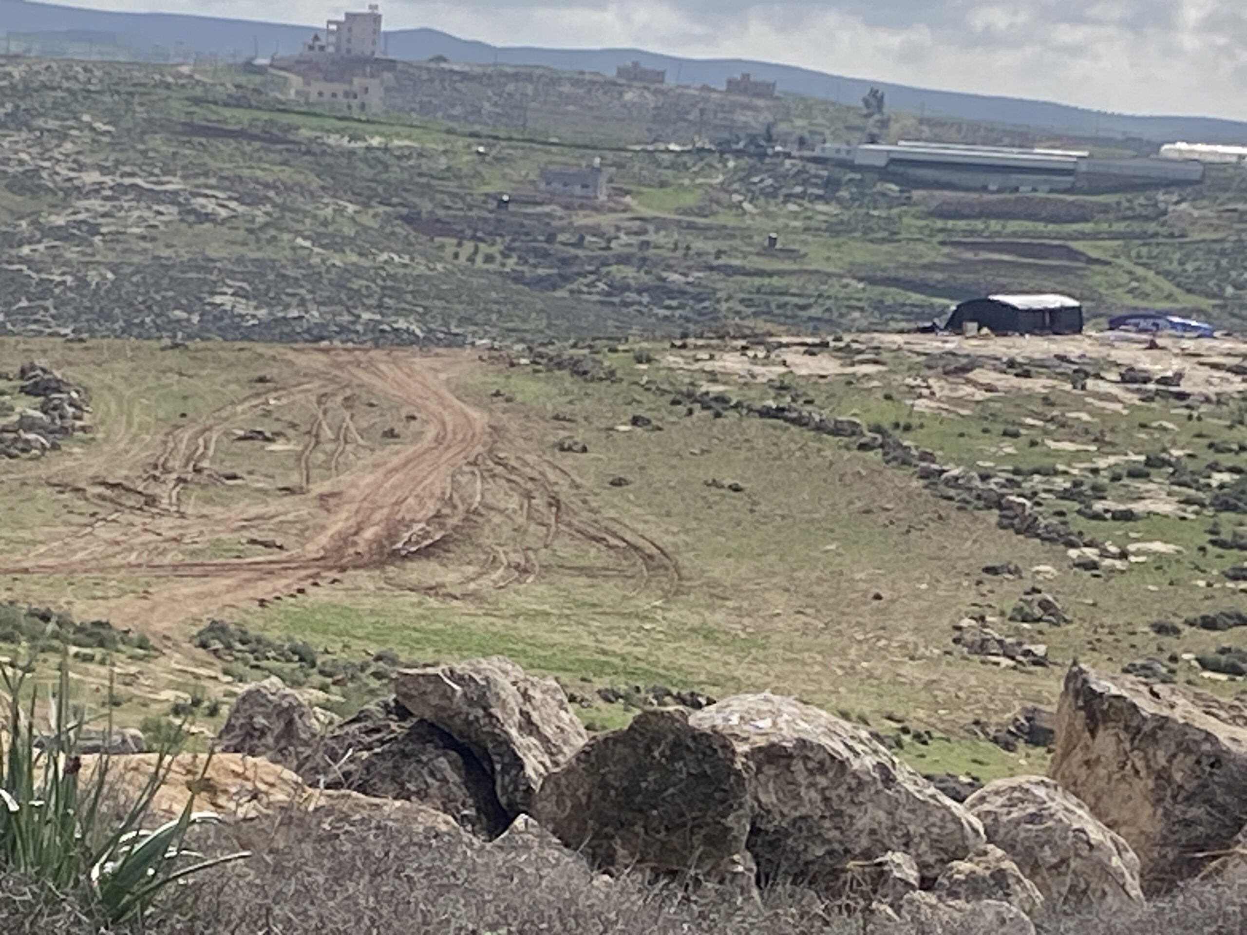
מצפון לאשתמוע בצדו המזרחי של הכביש, מול בריכה של מקורות מתארגן מאחז חדש: על הגבעה מבחינים בשני מבנים, אחד מהם עם גג מתכת קמור כמו דומים לו במקומות אחרים, כנראה ישמש כדיר. דרך עפר חדשה מובילה מהכביש לשם. עדיין לא הוצב דגל. מוחמד טוען כי לפני שבועיים לא היה דבר שם.
באותה סביבה, בתחתית הוואדי הישוב ח’לת אל-מופתי. ביום ראשון השבוע מסר בן המקום למוחמד ידיעה על פלישת הכבשים של המתנחלים אל שדותיו. צלצלנו אליו היום לשמוע איך הסתיים האירוע. מסתבר כי כשניסו לגרש את הכבשים הזרות הגיע הצבא ועצר שלושה בני משפחה: יוסוף א’ ס’, אחיו מוסטפא א’ ס’ ואחיין. הם נלקחו לכלא עופר והם עדיין שם. ומאז המתנחלים מגיעים בטרקטורונים כל יום ומונעים מהם לצאת מהבית ולהוציא את הכבשים למרעה.
סמוע – השער פתוח לכיוון כביש 6.
דהריה – השער סגור ומכוניות מעבירות נוסעים וסחורות “גב אל גב”.]
כרמה – השער פתוח.
עבדה – שני השערים (צפוני ודרומי) סגורים.
דורא – השער סגור; אל–פוואר – השער פתוח, נפתח כל יום מהבוקר ועד השעה 14.
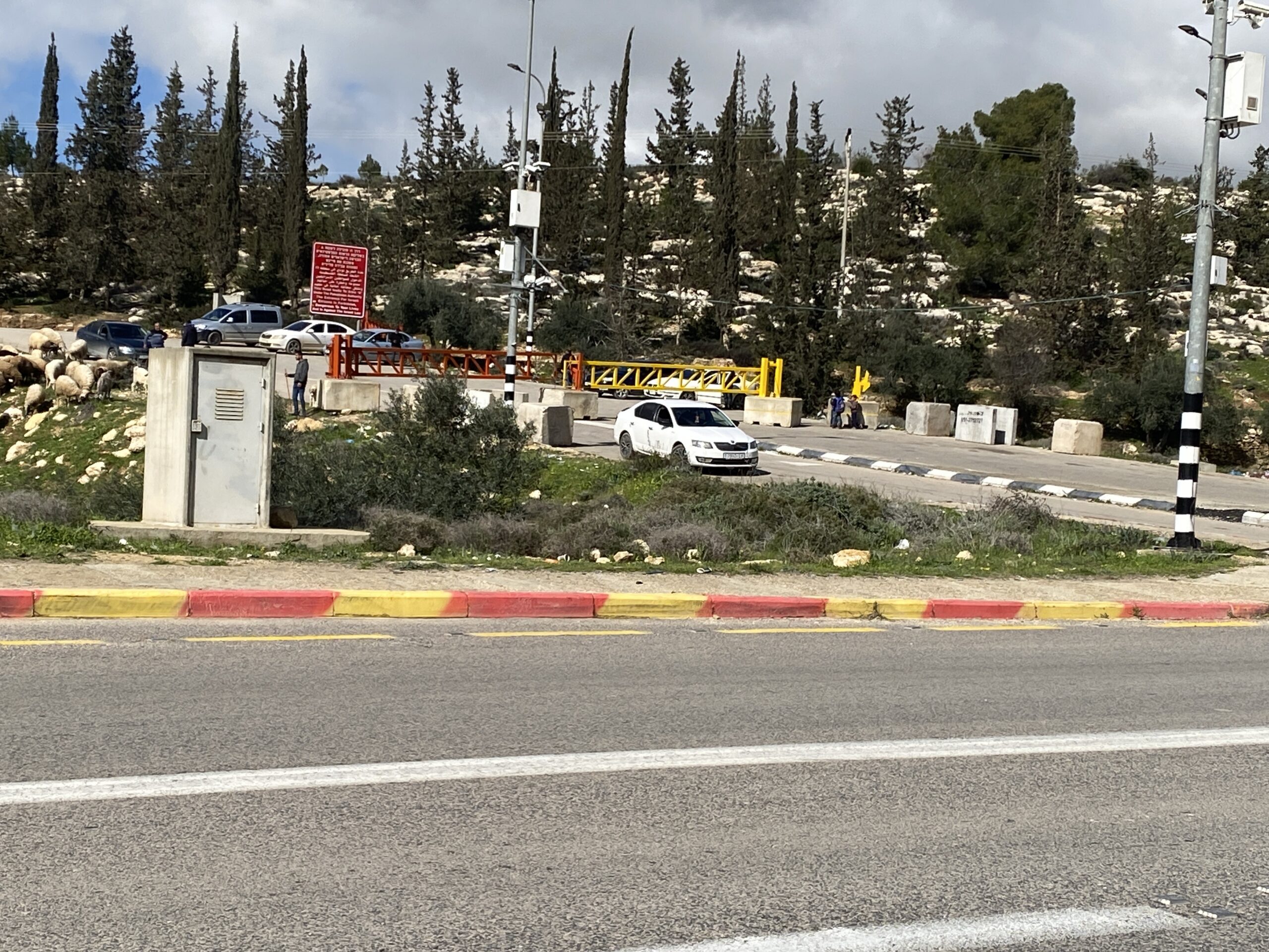
קילקיס – השערים משני צידי הכביש סגורים.
צומת סעיר, מול בית הספר לבנות – השערים משני הצדדים סגורים.
פגשנו שם את אחמד מבית ענון שספר על החיים הקשים: אין עבודה, כולם בבית, קר ואין דרך להסיק. העצים נגמרו, אספקת הגז לא מגיעה לכפרים באזור ויש להגיע לחברון, מה שמאוד קשה.
כביש 371
לקחנו טרמפ עד לצומת זיף חולה שחזר מבית החולים במזרח ירושלים. סיפר שמבית החולים עד המחסום יש לו תחבורה מסודרת (הדרך להחלמה?) ומשם עליו לחפש טרמפים מזדמנים עד הבית. נתנו לו חבילת מזון שנותרה, וכסף למונית עד לכפר שלו.
הטיילת בין מעון לכרמל ממשיכה להתפתח: נסללה באספלט לכל אורכה, נטעו עצים, הופיעו בוטקות עץ עם צל ומושבים למנוחה. ראינו גם משפחת מתנחלים עם תינוק פוסעים לאורכה.
א-תאווני – השער פתוח, השער מצידו השני של הכביש לכיוון יטא – סגור.
מתחת לישוב שני לבנה גדרו את כל השטחים של הפלסטינים מסביב כנראה כדי לטעת עצים ולהנציח את הפקעת השטח.
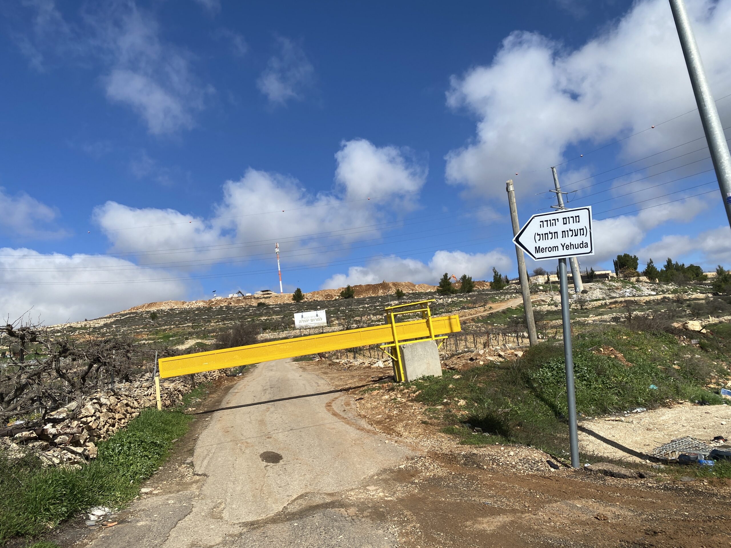
בצד המזרחי של הכביש, מול עשהאל, מופיע שלט חדש “מרום יהודה” מורה על גבעה שדרך כבר נכבשה אליה, וכנראה מתוכנן בה מאחז חדש.
מצב הרוח קשה ומתסכל ורק השקדיות הפורחות מקלות מעט.
Location Description
A-Tuwani
See all reports for this place-
A-Tuwani
The locals came to a-Tuwani during the 20th century from the village of Yatta. They settled in abandoned ruins, utilizing the arable land, pastures for grazing sheep and the abundance of natural caves for habitation. The residents who settled in the caves came from families who could not purchase land for houses in the mother villages, as well as shepherds who did not have enough land to graze. They were joined by clan members who quarreled with other families in the mother locality.
Some of the residents today live in concrete buildings built above the caves. In the area of the village are several water cisterns and an ancient water well called 'Ein a-Tuwani. Local residents are forced to buy water in containers and transport them through many road blocks to the village. With the help of international organizations, an electrical system was installed in the village. In the late 90s of the 20tTh century, an elementary school was established in the serving several small villages in the area.
In 2004, MachsomWatch began visiting and reporting from the Khirbet Tuwani cave village, which suffers badly from the settlers of nearby outposts, and especially from the extremist Ma'on outpost. . The settlers contaminate cisterns, poison the flocks and uproot trees.Particularly notable is the harassment of children from the surrounding villages on their way to school in a-Tuwani, so much so that military escort of children is required to separate them from the attackers (this was arranged following an initiative of the organization's members). In the past year, the escort has been without the vital presence of overseas volunteers.
Near a-Tuwani there are several families who have returned to the caves due to the incessant demolitions of the civil administration (as there is a total construction ban in all of area C). Destroyed are not only residential and agricultural buildings, but also water pipes, machinery. Even water cisterns are clogged up. a-Tuwani residents have created an association for non-violent demolition protests, but in the past year the army’s harsh harassment and settler violence have intensified and escalated. The incident of the small generator confiscation, which left a young man paralyzed, is one of many examples - any legitimate protection of property rights leads to violence and even shootings by the army and the civil administration.
Updated April 2022
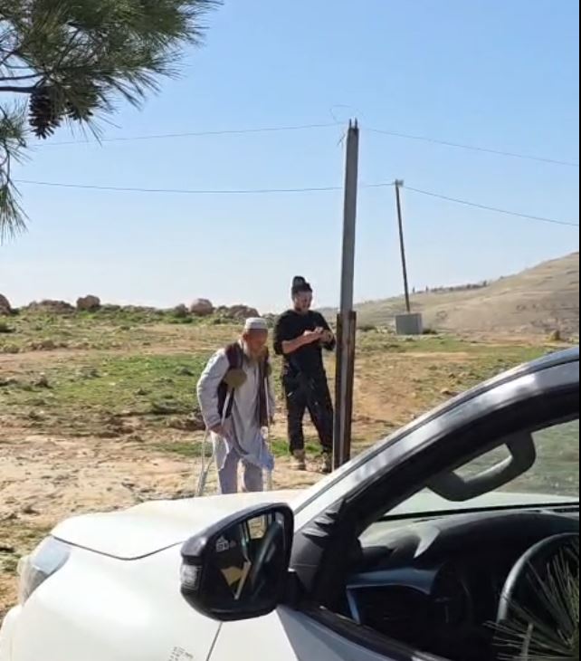 Feb-3-2026Security coordinator of the Abigail settlement, the one who injured Sheikh Saad (next to him)
-
Dura Al-Fawwar Junction
See all reports for this place-
Junction on Route 60: west - the town of El Dura, east - the Al Fawwar refugee camp. There is a manned pillbox at the junction. From time to time the army sets up flying checkpoints at the entrance to El Fawwar and Al Dura. Al-Fawwar is a large refugee camp (7,000 inhabitants in 2007) established in 1949 to accommodate Palestinian refugees from Be'er Sheva and Beit Jubrin and environs. There are many incidents of stone-throwing. In the vicinity of the pillbox there are excellent agricultural areas, Farmers set up stalls adjacent to the plots close to the road. In recent months the civil administration has set up dirt embankments thereby blocking access to the stalls, and making it impossible for the farmers to sell their vegetables. Updated April 2021, Michal T.
-
Sa'ir
See all reports for this place-
A relatively affluent suburb of Palestinian Hebron. West of Highway 60 leading from Bethlehem to Hebron. The entrance to Highway 60 and to Shuyukh and Beit Einun to the east is open, but is subject to changes - concrete blocks denying passage are stationed according to the needs of the army.
-
South Hebron Hills
See all reports for this place-
South Hebron Hills
South Hebron Hills is a large area in the West Bank's southern part.
Yatta is a major city in this area: right in the border zone between the fertile region of Hebron and its surroundings and the desert of the Hebron Hills. Yatta has about 64,000 inhabitants.
The surrounding villages are called Masafer Yatta (Yatta's daughter villages). Their inhabitants subsist on livestock and agriculture. Agriculture is possible only in small plots, especially near streams. Most of the area consists of rocky terraces.Since the beginning of the 1980s, many settlements have been established on the agricultural land cultivated by the Palestinians in the South Hebron Hills region: Carmel, Maon, Susia, Masadot Yehuda, Othniel, and more. Since the settlements were established and Palestinians cultivation areas have been reduced; the residents of the South Hebron Hills have been suffering from harassment by the settlers. Attempts to evict and demolish houses have continued, along with withholding water and electricity. The military and police usually refrain from intervening in violent incidents between settlers and Palestinians do not enforce the law when it comes to the investigation of extensive violent Jewish settlers. The harassment in the South Hebron Hills includes attacking and attempting to burn residential tents, harassing dogs, harming herds, and preventing access to pastures.
There are several checkpoints in the South Hebron Hills, on Routes 317 and 60. In most of them, no military presence is apparent, but rather an array of pillboxes monitor the villages. Roadblocks are frequently set up according to the settlers and the army's needs. These are located at the Zif Junction, the Dura-al Fawwar crossing, and the Sheep Junction at the southern entrance to Hebron.
Updated April 2022
Feb-3-2026Security coordinator of the Abigail settlement, the one who injured Sheikh Saad (next to him)
-
Zif Junction
See all reports for this place-
Zif Junction located on the crossroads that directs towards Road 356 to Yata. Yata is the district city of the southern Hebron Mountains. Usually, this junction is open to traffic. The nearby pillbox is unmanned. But the army and police are present occasionally, sometimes setting up a checkpoint and sometimes detaining residents from the big city. Often, the Israeli policemen inspect vehicles and distribute driving reports to Palestinian vehicles. s
-