Yinon Levi, the settler who killed Odeh Hadalin, takes control of large areas
We passed the Meitar checkpoint, deserted as usual…. almost two years! Since the beginning of the war. Which means that Palestinians are not allowed to enter and work in Israel. They have no job, no livelihood, two years! The situation is terrible; some really need help already. Others still manage somehow, to sell livestock, olive oil, labane, etc….
We turned onto Route 317 and saw before Asael, a huge, fenced area, an area that used to belong to Maktal Msalem, where Amar Awada lived, whose family was expelled at the beginning of the war, to Samu’. Now there are cows there and the area has been taken over by Yinon Levy, the man who shot and killed a Palestinian in Umm al-Khair.
Opposite Asael, you can see a settler bulldozer preparing the area for paving a road.
Along the way, you see many agricultural plots, fenced off by settlers and open lands which have still somehow remained in Palestinian hands.
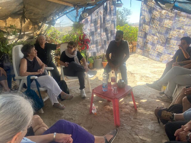
We arrived at Azzam in Susiya where he had a group of Israeli guests who came with their Arabic teacher. They take tours of the areas and, in the process, learn Arabic.
There were women from MachsomWatch and from the Road to Recovery. Road to Recovery is an Israeli volunteer organization that helps sick Palestinians, especially children, from the West Bank and Gaza to reach hospitals in Israel for life-saving medical treatment. Since many families can’t afford transportation, volunteers step in to drive patients from border checkpoints to hospitals and back.
Azzam is fluent in Hebrew, but because of the group, he spoke Arabic and their teacher translated.
Azzam talked about the history of friction between Israelis and Palestinians, which, according to him, began in 1986. Over time, and especially in recent years, it has gotten worse.
Today, Susiya is literally surrounded by outposts:
The Luski family, with cows
The Malka and Pavel families, with goats
The Peled family, with sheep.
Azzam spoke in detail about the incidents with them (incidents reported in our reports) and with the police….
Recently, the Palestinians organized themselves to guard the area at night until morning, there are shifts of about 10 people, with flashlights (of course without weapons), and this somewhat reduces the harassment of the settlers.
Night shifts are held also in Mufaqara.
On the other hand, in Khalet al-Daba’, the caves where the people lived have been destroyed and they are now living in tents…
The picture that emerges is very difficult, of expulsion, abuse, economic hardship and all this is pressing and stressing the Palestinians.
Let’s hope they hold out and don’t explode, because it seems that the Israeli government is waiting for….
Location Description
Meitar checkpoint / Sansana
See all reports for this place-
Meitar Checkpoint / Sansana The checkpoint is located on the Green Line and serves as a border crossing between Israel and the West Bank. It is managed by the Border Crossing Authority of the Defense Ministry. It is comprised of sections for the transfer of goods as well as a vehicle checkpoint (intended for holders of blue identity cards, foreign nationals or diplomats and international organizations). Passing of Palestinians is prohibited, except for those with entry permits to Israel. Palestinians are permitted to cross on foot only. The crossing has a DCO / DCL / DCL / DCL (District Coordination Office), a customs unit, supervision, and a police unit. In the last year, a breach has been opened in the fence, not far from the crossing. This breach is known to all, including the army. There does not appear to be any interest in blocking it, probably as it permits needed Palestinian workers without the bureaucratic permits to get to work in Israel. Food stalls and a parking area economy have been created, but incidents of violent abuse by border police have also been recorded. Updated April 2022
-
South Hebron Hills
See all reports for this place-
South Hebron Hills
South Hebron Hills is a large area in the West Bank's southern part.
Yatta is a major city in this area: right in the border zone between the fertile region of Hebron and its surroundings and the desert of the Hebron Hills. Yatta has about 64,000 inhabitants.
The surrounding villages are called Masafer Yatta (Yatta's daughter villages). Their inhabitants subsist on livestock and agriculture. Agriculture is possible only in small plots, especially near streams. Most of the area consists of rocky terraces.Since the beginning of the 1980s, many settlements have been established on the agricultural land cultivated by the Palestinians in the South Hebron Hills region: Carmel, Maon, Susia, Masadot Yehuda, Othniel, and more. Since the settlements were established and Palestinians cultivation areas have been reduced; the residents of the South Hebron Hills have been suffering from harassment by the settlers. Attempts to evict and demolish houses have continued, along with withholding water and electricity. The military and police usually refrain from intervening in violent incidents between settlers and Palestinians do not enforce the law when it comes to the investigation of extensive violent Jewish settlers. The harassment in the South Hebron Hills includes attacking and attempting to burn residential tents, harassing dogs, harming herds, and preventing access to pastures.
There are several checkpoints in the South Hebron Hills, on Routes 317 and 60. In most of them, no military presence is apparent, but rather an array of pillboxes monitor the villages. Roadblocks are frequently set up according to the settlers and the army's needs. These are located at the Zif Junction, the Dura-al Fawwar crossing, and the Sheep Junction at the southern entrance to Hebron.
Updated April 2022
 MuhammadFeb-24-2026South Hebron Hill, Beit Hagai: Paving an internal security road
-
Susiya
See all reports for this place-
Susiya The Palestinian area lies between the settlement of Susya and a military base. The residents began to settle in areas outside the villages in the 1830s and lived in caves, tents and sukkot. To this day they maintain a traditional lifestyle and their livelihood is based on agriculture and herding. Until the 1948 war, the farmers cultivated areas that extended to the Arad area. As a result of the war, a significant portion of their land left on the Israeli side was lost. After the 1967 war and the Israeli occupation, military camps were established in the area, fire zones and nature reserves were declared, and the land area was further reduced. The Jewish settlement in Susya began in 1979. Since then, there has been a stubborn struggle to remove the remains of Palestinian residents who refuse to leave their place of birth and move to nearby town Yatta. With the development of a tourist site in Khirbet Susya in the late 1980s (an ancient synagogue), dozens of families living in caves in its vicinity were deported. In the second half of the 1990s, a new form of settlement developed in the area - shepherds' farms of individual settlers. This phenomenon increased the tension between the settlers and the original, Palestinian residents, and led to repeated harassment of the residents of the farms towards the Palestinians. At the same time, demolition of buildings and crop destruction by security forces continued, as well as water and electricity prevention. In the Palestinian Susya, as in a large part of the villages of the southern Hebron Mountains, there is no running water, but the water pipe that supplies water to the Susya Jewish settlement passes through it. Palestinians have to buy expensive water that comes in tankers. Solar electricity is provided by a collector system, installed with donation funds. But the frequent demolitions in the villages do not spare water cisterns or the solar panels and power poles designed to transfer solar electricity between the villages. Updated April 2021, Anat T.
-