Susiya - Settlers with flocks of sheep near Palestinian homes
The crossing from the Meitar checkpoint to Highway 317 revealed a desolate area in Zanuta, with settler vineyards blooming on the left side of the road and a settler seen driving a tractor.
Houses in Zanuta are destroyed, and there are no Palestinian residents there.
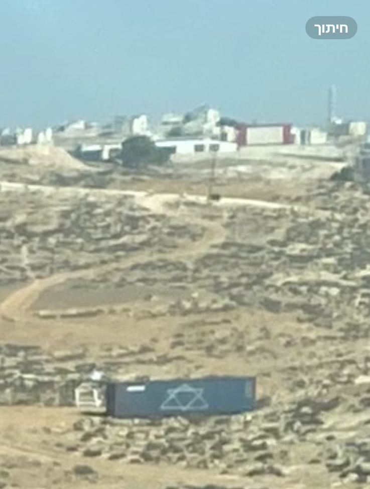
A new caravan has been placed in the Asa’el settlement area and the settlement is expanding, including new farms, and a new western road being built on Palestinian land.
In Susiya, settlers were seen with flocks of sheep near Palestinian homes.
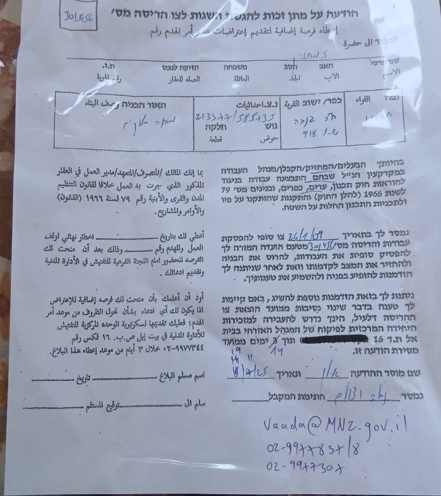
Fuad reports that at least six demolition orders were issued in the village of Jinba – for the school, the clinic, and the mosque – even though these are existing, old structures.
Location Description
Dura Al-Fawwar Junction
See all reports for this place-
Junction on Route 60: west - the town of El Dura, east - the Al Fawwar refugee camp. There is a manned pillbox at the junction. From time to time the army sets up flying checkpoints at the entrance to El Fawwar and Al Dura. Al-Fawwar is a large refugee camp (7,000 inhabitants in 2007) established in 1949 to accommodate Palestinian refugees from Be'er Sheva and Beit Jubrin and environs. There are many incidents of stone-throwing. In the vicinity of the pillbox there are excellent agricultural areas, Farmers set up stalls adjacent to the plots close to the road. In recent months the civil administration has set up dirt embankments thereby blocking access to the stalls, and making it impossible for the farmers to sell their vegetables. Updated April 2021, Michal T.
-
Meitar checkpoint / Sansana
See all reports for this place-
Meitar Checkpoint / Sansana The checkpoint is located on the Green Line and serves as a border crossing between Israel and the West Bank. It is managed by the Border Crossing Authority of the Defense Ministry. It is comprised of sections for the transfer of goods as well as a vehicle checkpoint (intended for holders of blue identity cards, foreign nationals or diplomats and international organizations). Passing of Palestinians is prohibited, except for those with entry permits to Israel. Palestinians are permitted to cross on foot only. The crossing has a DCO / DCL / DCL / DCL (District Coordination Office), a customs unit, supervision, and a police unit. In the last year, a breach has been opened in the fence, not far from the crossing. This breach is known to all, including the army. There does not appear to be any interest in blocking it, probably as it permits needed Palestinian workers without the bureaucratic permits to get to work in Israel. Food stalls and a parking area economy have been created, but incidents of violent abuse by border police have also been recorded. Updated April 2022
-
Mesafer Yatta
See all reports for this place-
This is happening in Fire Area 918 in the South Hebron Hills
On the eve of Remembrance Day (the day before Israel Independence Day), 4th May, 2022, the Israeli High Court decided on the transfer and expulsion of residents from 8 Palestinian communities in the area of Masafar Yata in the South Hebron Hills. Residents of the villages have been living under the threat of demolition, evacuation and expropriation since the IDF issued evacuation orders in 1999 based on the 1980s proclamation of their area of residence as a firing zone for IDF drills. None of the nearby settlements were included in this zone. The Masafer Yata Palestinian villages retain a special lifestyle and ancient agricultural culture. They also posess a clear historical documentation that testifies to a Palestinian settlement in this area, generations before the establishment of Israel, long ago in the caves and at later times outside them.
Evacuating residents from the area means destroying these historic villages and leaving entire families (about 2,000 people, children, adults, and the elderly) homeless. This is contrary to international law.
In June 2022, a firing drill started, and life became harder.
-
South Hebron Hills
See all reports for this place-
South Hebron Hills
South Hebron Hills is a large area in the West Bank's southern part.
Yatta is a major city in this area: right in the border zone between the fertile region of Hebron and its surroundings and the desert of the Hebron Hills. Yatta has about 64,000 inhabitants.
The surrounding villages are called Masafer Yatta (Yatta's daughter villages). Their inhabitants subsist on livestock and agriculture. Agriculture is possible only in small plots, especially near streams. Most of the area consists of rocky terraces.Since the beginning of the 1980s, many settlements have been established on the agricultural land cultivated by the Palestinians in the South Hebron Hills region: Carmel, Maon, Susia, Masadot Yehuda, Othniel, and more. Since the settlements were established and Palestinians cultivation areas have been reduced; the residents of the South Hebron Hills have been suffering from harassment by the settlers. Attempts to evict and demolish houses have continued, along with withholding water and electricity. The military and police usually refrain from intervening in violent incidents between settlers and Palestinians do not enforce the law when it comes to the investigation of extensive violent Jewish settlers. The harassment in the South Hebron Hills includes attacking and attempting to burn residential tents, harassing dogs, harming herds, and preventing access to pastures.
There are several checkpoints in the South Hebron Hills, on Routes 317 and 60. In most of them, no military presence is apparent, but rather an array of pillboxes monitor the villages. Roadblocks are frequently set up according to the settlers and the army's needs. These are located at the Zif Junction, the Dura-al Fawwar crossing, and the Sheep Junction at the southern entrance to Hebron.
Updated April 2022
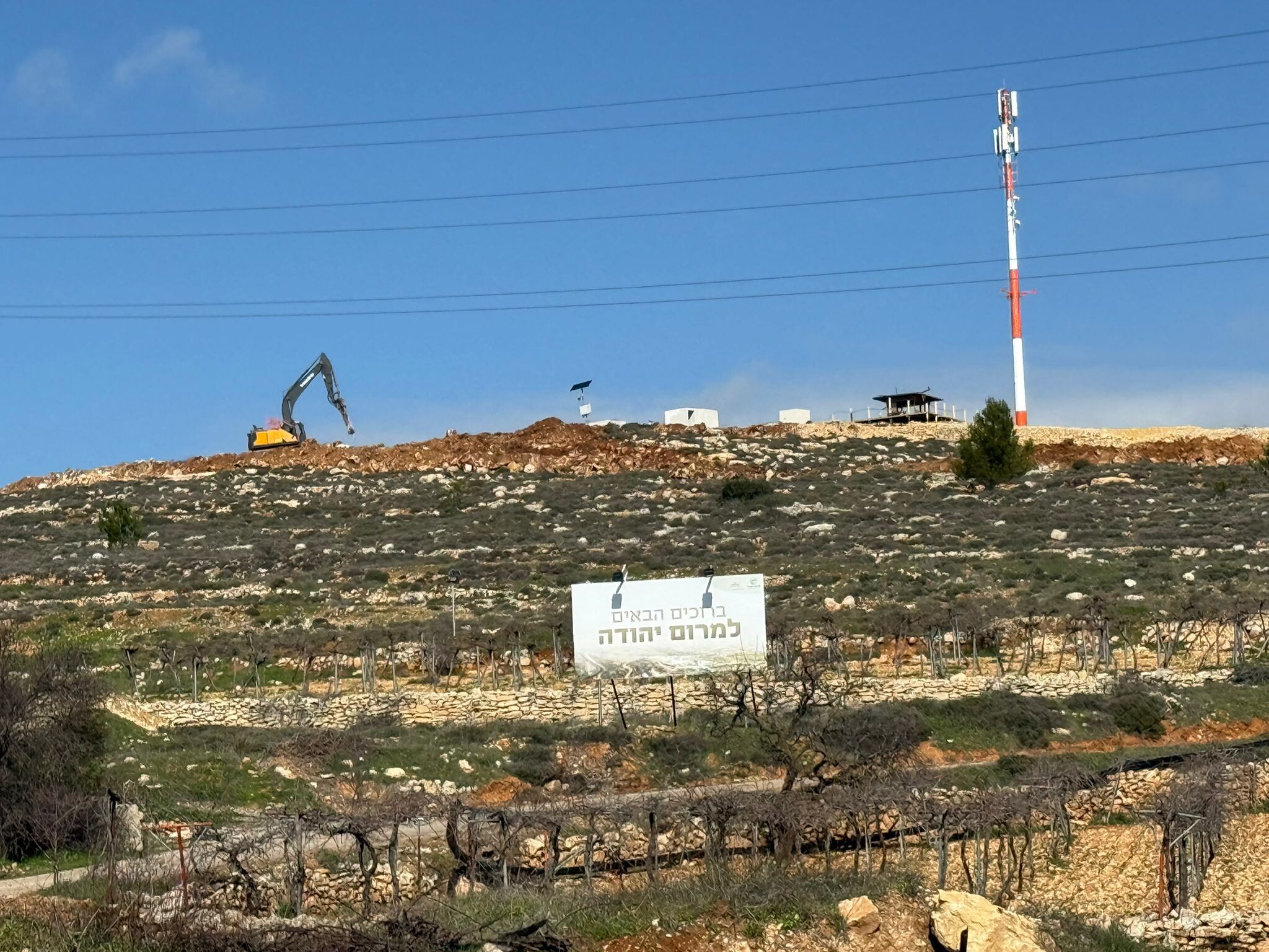 Muhammad D.Jan-20-2026New settlement - Merom Yehuda
-
Susiya
See all reports for this place-
Susiya The Palestinian area lies between the settlement of Susya and a military base. The residents began to settle in areas outside the villages in the 1830s and lived in caves, tents and sukkot. To this day they maintain a traditional lifestyle and their livelihood is based on agriculture and herding. Until the 1948 war, the farmers cultivated areas that extended to the Arad area. As a result of the war, a significant portion of their land left on the Israeli side was lost. After the 1967 war and the Israeli occupation, military camps were established in the area, fire zones and nature reserves were declared, and the land area was further reduced. The Jewish settlement in Susya began in 1979. Since then, there has been a stubborn struggle to remove the remains of Palestinian residents who refuse to leave their place of birth and move to nearby town Yatta. With the development of a tourist site in Khirbet Susya in the late 1980s (an ancient synagogue), dozens of families living in caves in its vicinity were deported. In the second half of the 1990s, a new form of settlement developed in the area - shepherds' farms of individual settlers. This phenomenon increased the tension between the settlers and the original, Palestinian residents, and led to repeated harassment of the residents of the farms towards the Palestinians. At the same time, demolition of buildings and crop destruction by security forces continued, as well as water and electricity prevention. In the Palestinian Susya, as in a large part of the villages of the southern Hebron Mountains, there is no running water, but the water pipe that supplies water to the Susya Jewish settlement passes through it. Palestinians have to buy expensive water that comes in tankers. Solar electricity is provided by a collector system, installed with donation funds. But the frequent demolitions in the villages do not spare water cisterns or the solar panels and power poles designed to transfer solar electricity between the villages. Updated April 2021, Anat T.
-
Zanuta
See all reports for this place-
Zanuta was a small rural Palestinian locality until its demolition. It was situated in the space around the town Dahariya in the South Hebron Hills, about a ten-minute ride from Meitar Checkpoint. There are documented remains of a large Byzantine settlement in the area. Since the Ottoman (Turkish Empire) period (1516-1917) Zanuta was documented as a locality of shepherds and farmers who live in the remains of the ancient structures and the residential caves near them.
Two individual ranches of colonists were created next to Zanuta: Meitarim (of the colonist Yinon Levi) to the east, and Yehudah (of the colonist Elyashiv Nachum) to the north. Endless attacks, harassments and attempt to chase away the Zanuta villagers have originated in these two outposts.
Until the expulsion, four families lived in the village: A-Samama, Al-Tel, Al Batat, and Al-Qaisia. Farming constituted their main economic activity and employed most of the villagers. The total area of the village is about 12,000 dunams, of which about 3,000 are tended, mostly with field crops.
This village has never had a master plan that would legitimize construction permits. The Civil Administration claimed it was too small and the distance to the next town, Dahariya, too great. For this reason, the Israeli authorities pressured the villagers to leave. The colonists did the job for them.
-