‘Anabta, Habla, Irtah (Sha’ar Efrayim), Jubara (Kafriat), Shave Shomron, Thu 3.10.13, Afternoon
Translation: Bracha B.A.
Habla Checkpoint – There is traffic and cars are being checked by the soldiers.
13:55 – The entrance to the village of Azun is open.
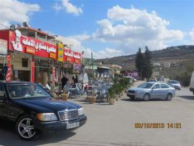
In the village of Dir Sharaf on the side of the road that once lead to the Beit Iba Checkpoint, we now see coffee houses that we were told are open until late at night.
14:35 – Temporary roadblock checkpoint at Shavei Shomron. Three soldiers and an army jeep are standing on both sides of the road.
17:00 – Anabta Checkpoint is not manned.
17:15 – Jobara Checkpoint – the soldiers ask where we were coming from. Three cars on the side of the road are 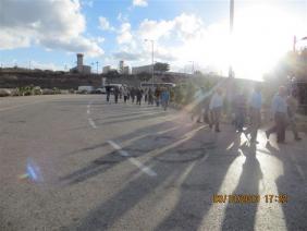 waiting to be issued tickets, evidently to help the national treasury.
17:22 – Irtah Checkpoint – Workers are returning home from a week's work in Israel. People complain about the crossing conditions in the morning. One of the workers reports that he arrives at the checkpoint at 04:00 AM but only comes out at 06:00 after being brought into the inspection rooms and being made to wait for a long time for no reason.
'Anabta CP
See all reports for this place-
'Anabta CP
The checkpoint is located south of the village of 'Anabta, at the intersection of Road 60 (leading to Nablus at the entrance to Area A), with Road (57, 557, 5576) facing west towards the Einav settlement and the checkpoint at the exit from the West Bank - Figs checkpoint. Until 2010 we used to watch the intersection and report the long columns created due to a slow inspection of the vehicles in both directions. Oct-28-2011Anabta checkpoint 24.10.11
-
Habla
See all reports for this place-
Habla CP (1393)
The Habla checkpoint (1393) was established on the lands of the residents of Qalqilya, on the short road that
connected it for centuries to the nearby town of Habla. The separation barrier intersects this road twice and cut off the residents of Qalqilya from their lands in the seam zone.(between the fence and the green line).
There is a passage under Road 55 that connects Qalqilya to the sabotage This agricultural barrier is used by the farmers and nursery owners established along Road 55 from the Green Line and on both sides of the kurkar road leading to the checkpoint.
This agricultural checkpoint serves the residents of Arab a-Ramadin al-Janoubi (detached from the West Bank), who pass through it to the West Bank and back to their homes. The opening hours (3 times a day) of this agricultural checkpoint are longer than usual, about an hour (recently shortened to 45 minutes), and are coordinated with the transportation hours of a-Ramadin children studying in the occupied in the West Bank. Nina SebaAug-18-2025Habla: The gate is in the process of closing
-
Irtah (Sha'ar Efrayim)
See all reports for this place-
The checkpoint is for Palestinians only. It is the main barrier to the passage of workers from the northern West Bank to Israel. Workers with a permit to work in Israel and also for trade (with appropriate permissions), medicine, and visiting prisoners. One can cross the checkpoint only on foot. The checkpoint is located north of Road 557 and south of Tulkarm. Operated by a civil security company, opening hours: between 4:00 and 19:00 on weekdays. As members of Machsom Watch, we began our shifts to this location in 2007. We arrived before it opened at 4 in the morning and report since, on the harsh conditions and the long and crowded queues of workers. The workers who pass by continue their journey by transportation to work throughout Israel. In the first period of its activity, about 3,000 and then 5,000 people passed through this checkpoint every day. Due to the small number of checking points and arbitrary delays for long periods of time in the "rooms", workers feared losing their transportation. Hence workers leave their homes at 2:30 at night to be among the first. Today, 15,000 pass and the transition is faster. Workers are still leaving their homes very early to get past the checkpoint at 7 p.m. In an adjacent compound, there is a terminal for the transfer of goods on a commercial scale, using the back-to-back method.
-
Jubara (Kafriat)
See all reports for this place-
The Jabra checkpoint was on Road 557, south of Tulkarm, on the side of the Figs Pass, which is located within the Palestinian Authority (a few kilometers east of the Green Line), and serves as an entry barrier from the territories to Israel. The checkpoint to the village of Jubara, which until 2013 was in the seam area, blocked and surrounded by a fence, was intended for the passage of the family members of the house next to the checkpoint, and also for the MachsomWatch volunteers (with special permission only), on their way to checkpoint 753. on the other side of the village. The soldiers supervising the "fig crossing" also supervised the crossing at this checkpoint, in our shifts we often waited a long time until the key was found and the gate opened. The checkpoint was abolished and became part of the separation fence that was moved west following the High Court.
-
Shave Shomron Checkpoint
See all reports for this place-
The checkpoint is on Route 60 (the main road to the northern West Bank), opposite settlement. Has been blocked to Palestinians since disengagement from Gaza and northern Samaria.
-