Atarot - acceleration of the process to build the Jewish neighbourhood
Jabel Mukaber, Nof Zion settlement, Silwan, At-Ttr, Shuafat and Anata refugee camps, Qalandiya
Following news we received about roadblocks that were placed throughout East Jerusalem last week, we went to check the situation in several neighbourhoods which we know. We found no manned internal barriers, but there is preparation for the immediate placement of barriers and also manned observation posts. There were also many house demolitions that are not related to the families of the victims – the authorities were waiting for an opportunity. It was also a day for the news about the acceleration of the process to build the Jewish Atarot neighbourhood.
The Palestinian residents of Jerusalem that we met did not talk about the worsening of their situation expected from the new government. Evidently they feel that whatever comes will come. The situation is already bad today, and they feel they have no way to change anything.
Jabel Mukaber – the drop-off junction for the schools (Al Madares) at the Talpiot East border
Concrete blocks and cement blocks are placed on the side of the road. Above you can see a manned soldier’s position on the stairs going down from Talpiot East neighbourhood to the junction. Those who are in the know at Sheikh Saed said, that checkpoint are put up in the mornings of when the children go to school and again during the hours when the Palestinians come from work in Jerusalem. And sometimes just unexpectedly. Today is Sunday so there is no school.
We travelled to the settlement of Nof Zion in Jabel Mukabar which is growing rapidly and bites into the surrounding rocks. A bus stands nearby to transport the settlers back and forth to Hebron road. This is unusual – explains the Arab driver. Usually only a round trip minibus is allocated. The view is really amazing. We continue to the road which goes down to the American road. It is being expanded, which is good. But why are we so suspicious and think that the road is intended mainly for the residents of Nof Zion to enable them to get to the roads which will lead them to the south and north of the West Bank?
There have been several demolitions this week in Jabel Mukabar and the nearby neighbourhood of Sawahra, which have been followed by the Palestinians protesting. According to information we received we tried to find one of the houses on the road that passes by the Kidron Valley, but were unsuccessful. The demolitions were not because of terrorism, but because of the lack of permits and also because many times there is also something else being planned for this location – a road, a settlement, in the end everything becomes clear.
Silwan
Another “candidate” which was notified today of an immediate demolition order is a house for 100 tenants in Wadi Qaddum. We already wrote about this last June:
“This is a beautiful house made of Jerusalem stone with elliptical balconies. It was built in 2014, 100 tenants live in it, but it does not have a license (it is almost impossible to get a building license in East Jerusalem).
The custodian of Palestinian properties and the municipality launched this year a comprehensive operation to check all the permits and registrations in the Land Registry Office of all the Palestinian houses in the east of the city in order to “make order” (that is, evacuate and destroy). It lies in a wadi below the Mount of Olives, from where it is planned to dig an apartheid tunnel that will bring the residents of the settlements of the South Bank to the roads of the North Bank. The municipality claims that the area is not for living but for sports, recreation and entertainment. Sounds as if they want to mock the Palestinians.”
It turns out that there was a verbal agreement with the municipality to settle the issue. But the deputy mayor, Arya King, a settler from the City of David, does not give up. And he has a lot of police backing now.
In Silwan we also saw works to restore the Shiloah pool in honour of its opening to the public. The works started at the end of December after years of delays. At the corner of the street, settlers are marching from all directions with children for transport to kindergartens outside the neighbourhood. They look more and more like the owners of the place. Transportation is at our expense of course.
There is no roadblock on the way up to the Dung Gate, but the road is unusually narrow, the Empire of the City of David consuming a large part of the road.
At-Tur and Shuafat-Anata
In Wadi Joz there is a new traffic light at the turn to the garages and the road is being widened. Kamal comments that precisely at the intersection at the end of the hill, near the Augusta Victoria Hospital – an intersection with four busy intersections to Wadi Joz, Mount Scopus, Makassed hospital and At-Tur – there has been a need for a roundabout or a traffic light for years, and nothing is done about it..
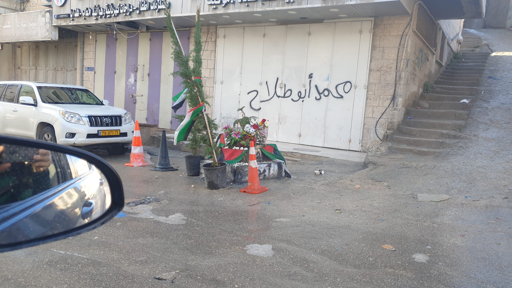
You enter through Road No. 1 to the Shuafat refugee camp checkpoint, which looks like a battlefield. As usual, the soldiers huddle in a group. Even now at 9:30 in the morning it’s quite congested, even after students and workers have left earlier for work and school. There were many clashes in the camp following the demolition of the house of the terrorist who shot a female soldier at the checkpoint. A 16-year-old boy, Muhammad Ali Ibn Muhammad, was killed by police fire at a demonstration two weeks ago, and at the place of his death there is a memorial with flowers on the road.
This week the eastern entrance to Anata was blocked for several days. Now there is no checkpoint, but at the exit junction for the 437 leading to Hizma, Jerusalem and the Dead Sea there is a new post monitoring the traffic.
Qalandiya
The road to the Qalandiya checkpoint is congested at all hours of the day. In the traffic circle east of the checkpoint we saw a freshly tarred road, on the checkpoint of which it says “to the new path”. Let’s hope that the new short path for traffic coming from the checkpoint will ease the traffic jam in both directions. But nothing is sure here.
We went to see the entrance to the Qalandiya camp (Jerusalem area). There is no barrier today (there was for part of last week), but the garbage pile may still reach the road…
We retraced our steps and climbed our secret hill in A-ram overlooking the checkpoint and the road works. There are rumours that the work on the Israeli-only sunken crossing is about to be completed, but it doesn’t look like that. It is difficult to understand how the sunken crossing will lead to Road 443 and the Begin Road to Jerusalem.
This week the eastern entrance to Anata was blocked for several days. Now there is no checkpoint, but at the exit junction for the 437 leading to Hizma, Jerusalem and the Dead Sea there is a new post monitoring the traffic.
Today it was also announced that the plans for the construction of the Jewish (Orthodox) neighbourhood of Atarot on the area of the old airport are advancing rapidly. This will be very close to the separation wall of Kafr Aqab (a Palestinian neighbourhood of Jerusalem that was pushed beyond the wall). Another wedge of 9,000 residents between Ramallah and Jerusalem, in front of the towers without building permits in the neglected Kafr Aqab. A pre-written script for big trouble.
A-Ram
See all reports for this place-
two kilometers south of Qalandiya and 300 metres north of Neve Yaacov Junction, in Dahiyat el-Barid Quarter. Checkpoint has operated since 1991, in a Palestinian area annexed to Jerusalem in 1967. The checkpoint has been inactive since the middle of 2009.
The wall was built on the road that led to Jerusalem. Since then the situation in the town has deteriorated. Houses are abandoned and half finished, most of the businesses have closed. Severe neglect around the fence and on the streets. Those who could left. Updated January 2024
-
Checkpoint Shu'afat camp / Anata-Shu'afat (Jerusalem)
See all reports for this place-
The Shu’afat checkpoint is located in the northern part of East Jerusalem at the exit from the village of Anata and the Shu’afat refugee camp, which are located in the area annexed to Jerusalem in 1967. The refugee camp borders the Shu’afat neighborhood to the west, Pisgat Ze’ev to the north, the French Hill neighborhood to the south and the planned expansion of Ma’aleh Adumim to E-1 in the east. It was established in 1966 for 1948 refugees from the West Bank and was populated after the Six Day War by persons who had been expelled from the Jewish Quarter. Today its population comprises some 25,000 people holding blue ID cards and some 15,000 people with Palestinian ID cards. The camp lacks adequate infrastructure and services, and suffers from poverty, neglect and overcrowding. All its buildings are connected to the public electricity and water infrastructure, but not all are connected to the sewer system. The camp’s services are provided by UNRWA, except for those such as health clinics and transportation of pupils to schools in Jerusalem. In 2005, the Israeli High Court of Justice rejected a suit by the residents requesting that the route of the separation fence be drawn such that the camp would remain on the Israeli side, but conditioned its approval of the route on the establishment of a convenient and rapid crossing facility for the inhabitants of the neighborhood, most of whom are residents of Jerusalem.
A temporary checkpoint operated there until December, 2011. It was extremely congested during rush hours, and dangerous for pedestrians (especially children) because of inadequate safety provisions. The new checkpoint was inaugurated south of the old one, for public and private transportation and for pedestrians, intended solely for the residents of the camp – holders of blue ID cards, and those with Palestinian ID cards who possess appropriate permits. There are five vehicle inspection stations at the checkpoint, and two for pedestrians (one of which is currently closed) where scanners have been installed but are not yet operating. According to the army, representatives of government agencies will also be present to provide services to residents of the neighbourhood. The pedestrian lanes are very long, located far from the small parking lots, and accessible through only a single revolving gate.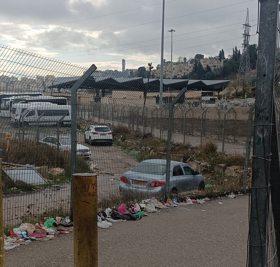 Ronny PerlmanDec-10-2025Anata Checkpoint: Neglect
-
Jabel Mukaber (Jerusalem)
See all reports for this place-
Jabal Mukaber is located on the eastern and northern slopes of Mount Atz (or "Jabal Mukaber" in its Arabic name). It was founded by the Bedouin tribe of Arab a-Sawahra. Today, the village is considered one of East Jerusalem neighborhoods. It numbers about 30,000 residents living on 1,010 dunams. The village has five main clans, numbering several hundred families. During the British Mandate, the tribe moved to live in a huge complex of permanent housing that was named as-Sawahra, with the part east of the Kidron Valley called as-Sawahra a-Sharqiya (Eastern Sawahra) and the western part – Sawahra al-Gharbiyya. The separation fence currently separates Jabal Mukaber from Sawahra a-Sharqiya.
The houses of Jabal Mukaber wrap around the ridge from the north and east, along one of the tributaries of the Kidron River. In the eastern part, the village houses border the Jewish East Talpiot neighborhood. most of the residents of the village are considered residents of Jerusalem, have blue identity cards and enjoy full civil rights in Israel, except for the right to vote for the Knesset and receive an Israeli passport.
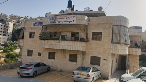
The residents of Jabel Mukaber suffer from lack of Outline Plan for the village, overcrowding and a lack of residential and public spaces. Thus, there is a phenomenon of illegal construction in the neighborhood. Demolitions of houses without building permits have been carried out over the years, but since the 7th October War, their rate has increased.
In 2010, a wall was built separating it from its sub-neighborhood A-Sheikh Sa'ed. The wall left many residents with Palestinian IDs without Jerusalem residency and they lost their freedom of movement in Jerusalem.
In the northern part of the neighborhood, construction began in 2005 of a luxury Jewish neighborhood called Nof Zion. The neighborhood was planned to have about 400 housing units, a commercial center and a hotel. However, in April 2025, it was announced that it would be expanded. The apartments were marketed mainly to the religious community in the United States. Alongside the Nof Zion neighborhood, a plan is being promoted to establish the Nof Zahav neighborhood on state land in the Jabal Mukaber neighborhood. This plan also includes residential areas and hotels for tourists, and a place has been allocated for a synagogue, but not for the construction of a mosque.
During and after the Second Intifada, several residents of the neighborhood were involved in terrorist attacks: On March 6, 2008, the attack on Merkaz HaRav Yeshiva in the Kiryat Moshe neighborhood of Jerusalem, in which eight of the yeshiva's students were murdered; On November 18, 2014, an attack on the "Kehilat Bnei Torah" synagogue during morning prayers in the Har Nof neighborhood of Jerusalem; A resident of Jabal Mukaber carried out a car bombing on the Armon Hanatziv promenade. The terrorist drove his truck into a group of cadets. Updated April 2025
-
Kufr 'Aqab
See all reports for this place-
Kufr 'Aqab
25,000 people live in this village, and since the erection of the Separation Wall, it has been disconnected from Jerusalem and become a neighborhood totally abandoned as far as law enforcement and planning and construction are concerned. The thousands of inhabitants of this undefined urban area pay municipal taxes to the city of Jerusalem but the Israeli authorities – municipality, police, and various service companies – hardly enter these places, and the Palestinian authorities avoid them too since the Oslo Accords forbid them to act within Jerusalem’s jurisdiction.
MachsomWatch teams coming to their Qalandiya vigils sometimes go through the village itself, and the organization’s tours include the enclaves north of Jerusalem.
-
Qalandiya Camp
See all reports for this place-
Qalandiya Camp The camp was founded east of the village of Qalandiya in 1949 and became inhabited by Palestinian refugees from Jerusalem and the surrounding villages whose homes had remained on the Israeli side of the armistice lines. The camp was included in Jerusalem’s municipal jurisdiction after 1967, and since the erection of the Separation Wall has been disconnected from the city and become no-man’s-land between Jerusalem and Ramallah. It numbers about 10,000 inhabitants and many of them hold a Jerusalem ID. It is considered one of the most difficult camps both from a criminal and a ‘security’ standpoint, and also one of the most neglected and impoverished. It suffers from poverty, neglect, crime, illegal construction, and the lack of proper municipal services. Terrorist attackers have come from there, and it often seems ‘security’ incidents, numerous incursions, and arrests, including the killing of youths following stone-throwing.
-
Qalandiya Checkpoint / Atarot Pass (Jerusalem)
See all reports for this place-
Click here to watch a video from Qalandiya checkpoint up to mid 2019 Three kilometers south of Ramallah, in the heart of Palestinian population. Integrates into "Jerusalem Envelope" as part of Wall that separates between northern suburbs that were annexed to Jerusalem in 1967: Kafr Aqab, Semiramis and Qalandiya, and the villages of Ar-Ram and Bir Nabala, also north of Jerusalem, and the city itself. Some residents of Kafr Aqab, Semiramis and Qalandiya have Jerusalem ID cards. A terminal operated by Israel Police has functioned since early 2006. As of August 2006, northbound pedestrians are not checked. Southbound Palestinians must carry Jerusalem IDs; holders of Palestinian Authority IDs cannot pass without special permits. Vehicular traffic from Ramallah to other West Bank areas runs to the north of Qalandiya. In February 2019, the new facility of the checkpoint was inaugurated aiming to make it like a "border crossing". The bars and barbed wire fences were replaced with walls of perforated metal panels. The check is now performed at multiple stations for face recognition and the transfer of an e-card. The rate of passage has improved and its density has generally decreased, but lack of manpower and malfunctions cause periods of stress. The development and paving of the roads has not yet been completed, the traffic of cars and pedestrians is dangerous, and t the entire vicinity of the checkpoint is filthy. In 2020 a huge pedestrian bridge was built over the vehicle crossing with severe mobility restrictions (steep stairs, long and winding route). The pedestrian access from public transport to the checkpoint from the north (Ramallah direction) is unclear, and there have been cases of people, especially people with disabilities, who accidentally reached the vehicle crossing and were shot by the soldiers at the checkpoint. In the summer of 2021, work began on a new, sunken entrance road from Qalandiya that will lead directly to Road 443 towards Jerusalem and Tel Aviv. At the same time, the runways of the old Atarot airport were demolished and infrastructure was prepared for a large bus terminal. (updated October 2021)
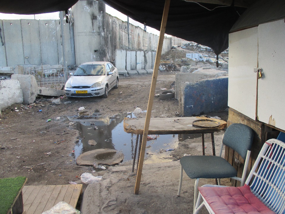 Tamar FleishmanNov-30-2025Qalandiya: Puddles and dirt after the rain
-
Sheikh Sa'ed
See all reports for this place-
A checkpoint limited to pedestrians, located on Jerusalem’s municipal boundary.
The checkpoint sits on the separation fence at the entrance to Sheikh Sa’ad, dividing it from its neighbourhood of Jabel Mukkabar. It’s manned by Border Police soldiers and private security companies and operates 24 hours a day. Palestinians are forbidden to go through, other than residents of Jabel Mukkabar or Sheikh Sa'ad who have permits. Both groups are permitted through only on foot. Residents of East Jerusalem who don’t live in Jabel Mukkabar are also allowed to cross to Sheikh Sa’ad, but not in the opposite direction; they must return through the Sawahira ash Sharqiya checkpoint.
 Local residentDec-10-2025Jerusalem: Ronny and Khalil
-
Silwan
See all reports for this place-
Silwan is south of the Old City of Jerusalem and has become one of the main confrontation areas with settlers.
-