‘Awarta, ‘Azzun ‘Atma, Beit Furik, Burin (Yitzhar), Huwwara, Shomron Crossing, Za’tara (Tapuah), Thu 2.12.10, Morning
Translation: Suzanne O.
It now appears to be more difficult to get from Kafr Kassem to the Kfar HaYarok than from Nablus to Ramallah.
Azzun Atma
6:35 a.m.
There are a lot of labourers and many vehicles waiting at the side of the road for the right combination of labourer and contractor.
In the netted sleeve there are very few labourers. Both the military police and two soldiers are stationed close to the opening of the sleeve and the labourers walk by them on their way to the computer check. From time to time a soldier checks the bags of food held by the labourers with an electronic device.
The soldiers asked us to leave their area of the roadblock and we found no reason to stay. They appear to be strict on order because they did not allow the young coffee vendors to go into the other side of the sleeve and sell coffee to the queue.
We asked the drivers to explain the short queue. They said that since the completion of the olive picking the number of permit holders has dropped drastically. During the olive picking season many Palestinians were given a two month permit and these have now run out. (Have the army proof that the large number of permits endangered the security of the State? Or is it that a contractor is making money by bringing in foreign labour?)
Shomron Crossing
6:45 a.m.
There is no police presence at the entrance and no queue at all at the exit.
The entrances to Marda & Zeita are open.
Za'atara/Tapuach
7:05 a.m.
There is heavy vehicular traffic at the top of the road. There are no soldiers in the lookout post on the menorah roundabout. Soldiers from the Border Police in smart uniforms have taken control of the roadblock.
In Huwwara town military vehicles drive around and one is parked in the town centre.
Beit Furic
7:30 a.m.
The 'no roadblock' routine continues. The traffic flows with no hindrance. A soldier asks how we are from the heights of the lookout tower.
Awarta
7:45 a.m.
The yellow barrier is chained up and bars the crossing to vehicles; the sign directs them to Huwwara roadblock.
A generator hums under the tower which testifies to the presence of soldiers within. They are probably monitoring that no Palestinian drives along Madison Way. It would be interesting to know if they open the gate to their neighbours in the adjacent house when they want to drive to the village or to an ambulance from Awarta hurrying to the hospital in Nablus. We hooted and waited but they did not put their heads out and we were unable to find anything out.
Huwwara
7:50 a.m.
There are almost no cars at the entrance to or the exit from Nablus and no queue at all. A dog handler is present. From time to time a car is stopped at the side of the road for a thorough inspection. When we approach two soldiers hurry over and ask us to leave the area of the roadblock 'for our own safety'. The whole point of humanitarian organisations does not impress them. We move away to the yellow barrier and this does not satisfy them. In their opinion the roadblock reaches up to the roundabout. One of the soldiers, accompanied by a sergeant, marches behind us holding his weapon in his hand until we get into our vehicle and leave.
Burin/Yitzhar
8:00 a.m.
A military vehicle is parked facing the road with its engine running, but with no soldiers in sight.
Za'atara/Tapuach
8:10 a.m.
There is a constant light stream of cars. Border Police are inspecting a car thoroughly. A traffic police patrol car is parked near them.
There are notices along all the roads calling for a mass assembly on Sunday bearing the motto – establish new settlements.
On the way home from Kafr Kassem to the Kfar HaYarok junction we crawl along bumper to bumper for almost an hour.
'Awarta
See all reports for this place-
Awarta, an internal checkpoint in the heart of the West Bank, is located east of the Hawara checkpoint, at the junction of Roads 555 (which was forbidden for Palestinian traffic in this area) and the entrance road to Nablus. It was one of the four checkpoints that surrounded Nablus until 2009. We used to watch it at Huwwara shifts because it was the only one where goods could be transferred to and from Nablus, using the back-to-back method. It was operated by the army, from 06:00 to 20:00. Until 2009.
 Ronit Dahan-RamatiJan-6-2026Awarta: Traffic jam on the way to Nablus
-
'Azzun 'Atma
See all reports for this place-
'Azzun 'Atma
A Palestinian village of about 1,800 residents. The settlement of Sha'arei Tikva was established on its land adjacent to it, and the settlement of Oranit was established on its agricultural lands. By 2013, the separation fence had passed through the village and a checkpoint staffed by the army allowed the residents to cross from side to side. After building a massive wall surrounding the village and some of its agricultural lands, the residents went daily for five years to their lands that remained in the Seam Zone through the Oranit agricultural checkpoint (4). Since 2018 it has only opened during the olive harvest and the farmers have to pass daily at the Beit Amin / Abu Salman checkpoint (1447), about 3 kilometers north.From a report from March 24, 2021: "The farmers from Beit Amin and Azon Atma are happy that since February 21 the Oranit checkpoint .is going to be open 3 times a day, The farmers are really developing the place."
Report from July 14, 2024: "Ornit checkpoint is closed . The Beit Amin/Abu Salman agricultural checkpoint is closed (there is no contact with the military to check if it opens rarely), the Ezbat Jaloud checkpoint was opened once a day before the war.
Updated for July 2024
 Apr-11-2019Azoun: The main entrance to village blocked now for several weeks
-
Beit Furik checkpoint
See all reports for this place-
One of the three internal checkpoints that closed on the city of Nablus - Beit Furik to the east, Hawara to the south, Beit Iba to the west. The checkpoint is located at the junction of Roads 557 (an apartheid road that was forbidden for Palestinians), leading to the Itamar and Alon Morea settlements and Road 5487. The checkpoint was established in 2001 for pedestrians and vehicles; The opening hours were short and the transition was slow and very problematic.Allegedly, the checkpoint is intended to monitor the movement to and from Nablus of the residents of Beit Furik and Beit Dajan, being the only opening outside their villages. Since May 2009 the checkpoint is open 24 hours a day, the military presence is limited, vehicles can pass through it without inspections, except for random inspections. (Updated April 2010)
-
Burin (Yitzhar)
See all reports for this place-
Burin (Yitzhar)
This is a Palestinian village in the Nablus governorate, a little south of Nablus, on the main road passing through the West Bank. The settlements: Yitzhar and Har Bracha, settled in locations that surrounded the village, placed fences so it is cut off the main road.
There are around 4000 inhabitants. Most of them are engaged in agriculture and pasture, although many graduates of the two secondary schools continue to study at the university. Academic positions are hardly available, they find work as builderd, or leave for the Gulf countries.
The village lands were appropriated several times for the establishment of Israeli settlements and military bases, and as a result, Burin's land and water resources dwindled. lSince 1982, more than 2,000 dunams of village land have been declared "state land" and then transferred to Har Bracha settlement.
Over the past few years and more so since 2017, the villagers have been terrorized by the residents of Yitzhar and Har Bracha, the Givat Ronen outpost and others. Despite the close proximity of soldiers to an IDF base close to one of the village's schools, residents are suffering from numerous stone-throwing events, vehicle and fire arson, also reported in the press.
In 2023, the prevention of the olive harvest in the village plot was more violent than ever. Soldiers and settlers walked with drawn weapons between the houses of the village and demanded that people stop harvesting in the village itself and in the private plots outside the village. The settlers from Yitzhar and Giv'at Roned raided the olive groves and stole crops. 300 olive trees belonging to the residents of Burin, near Yitzhar, were uprooted. The loss of livelihood from the olives causes long-term economic damage to the farmers' families, bringing them to the point of starvation.
(updated for November 2023)
-
Huwwara
See all reports for this place-
The Huwwara checkpoint is an internal checkpoint south of the city of Nablus, at the intersection of Roads 60 and 5077 (between the settlements of Bracha and Itamar). This checkpoint was one of the four permanent checkpoints that closed on Nablus (Beit Furik and Awarta checkpoints to the east and the Beit Iba checkpoint to the west). It was a pedestrian-only barrier. As MachsomWatch volunteers, we watched therre since 2001 two shifts a day - morning and noon, the thousands of Palestinians leaving Nablus and waiting for hours in queues to reach anywhere else in the West Bank, from the other side of the checkpoint the destination could only be reached by public transport. In early June 2009, as part of the easing of Palestinian traffic in the West Bank, the checkpoint was opened to vehicular traffic. The passage was free, with occasional military presence in the guard tower. Also, there were vehicle inspections from time to time. Since the massacre on 7.10.2023, the checkpoint has been closed to Palestinians.
On February 26, 2023, about 400 settlers attacked the town's residents for 5 hours and set fire to property, such as houses and cars. Disturbances occurred in response to a shooting of two Jewish residents of Har Bracha by a Palestinian Terrorist. The soldiers stationed in the town did not prevent the arson and rescued Palestinian families from their homes only after they were set on fire. No one was punished and Finance Minister Smotrich stated that "the State of Israel should wipe out Hawara." Left and center organizations organized solidarity demonstrations and support actions for the residents of Hawara.Hawara continued to be in the headlines in all the months that followed: more pogroms by the settlers, attacks by Palestinians and a massive presence of the army in the town. It amounted to a de facto curfew of commerce and life in the center of the city. On October 5, 2023, MK Zvi established a Sukkah in the center of Hawara and hundreds of settlers backed the army blocked the main road and held prayers in the heart of the town all night and the next day. On Saturday, October 7, 23 The "Swords of Iron" war began with an attack by Hamas on settlements surrounding Gaza in the face of a poor presence of the IDF. Much criticism has been made of the withdrawal of military forces from the area surrounding Gaza and their placement in the West Bank, and in the Hawara and Samaria region in particular, as a shield for the settlers who were taking over and rioting.
On November 12, 2023, the first section of the Hawara bypass road intended for Israeli traffic only was opened. In this way, the settlers can bypass the road that goes through the center of Hawara, which is the main artery for traffic from the Nablus area to Ramallah and the south of the West Bank. For the construction of the road, the Civil Administration expropriated 406 dunams of private land belonging to Palestinians from the nearby villages. The settlers are not satisfied with this at the moment, and demand to also travel through Hawara itself in order to demonstrate presence and control.(updated November 2023)
. Shoshi AnbarMay-18-2025Huwara: The old houses in Area C
-
Shomron Crossing
See all reports for this place-
Shomron Crossing The Shomron checkpoint for vehicles. is located east of Rosh HaAyin and Kafr Qassem, on Road 5 (Trans-Samaria) leading to Ariel and the Za'atara junction. It is intended for blue ID cardholders, foreign guests or diplomats, and international organizations only. In 2009 the management was entrusted to a civil security company.
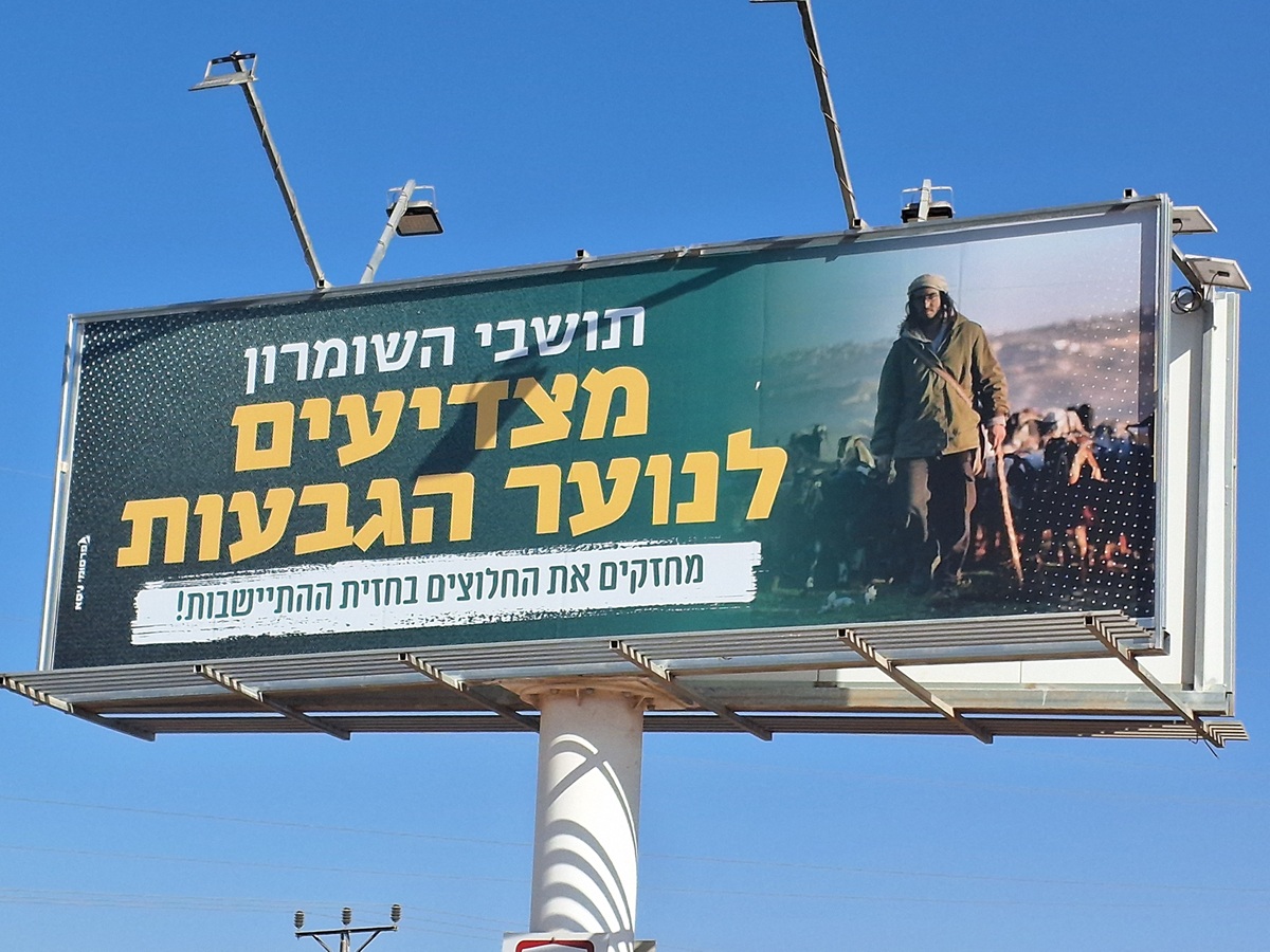 Ronit Dahan-RamatiAug-21-2025Highway 505: Salute to the Hilltop Youth
-
Za'tara (Tapuah)
See all reports for this place-
Za'tara (Tapuah) Za'tara is an internal checkpoint in the heart of the West Bank, at the intersection of Road 60 and Road 505 (Trans-Samaria), east of the Tapuah settlement. This checkpoint is the "border" marked by the IDF between the north and south of the West Bank, in accordance with the policy of separation between the two parts of the West Bank that has been in place since December 2005. At the Za'tara checkpoint, there are separate routes for Israelis and Palestinians. In the route for Israelis, there are no inspections and the route for Palestinians inspects. The queue lengthens and shortens suits. The checkpoint is open 24 hours a day. The checkpoint is partially staffed and the people who pass through it are checked at random.
 Shoshi AnbarSep-27-2023Za'atra (Tapuah Intersection). Signs
-