‘Azzun ‘Atma, Habla, Huwwara, Kifl Harith, Za’tara (Tapuah)
Flying Checkpoints – turns out they are rather permanent despite their name – at the entrance to Burin village, under the bridge connecting Burin and Madama, and between the villages of Madama and Asira al Qibliya.
13:40 – Habla Checkpoint
Few passers at this time. Later, the gate will only be opened for a single hour in the evening.
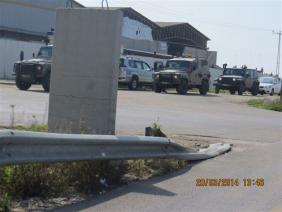
13:50 Army jeeps park at the entrance to the village of Izbat Tabeeb (first photo).
Inside, the village is quiet. At Funduq villge we were told of a flying checkpoint at Jit junction. When we passed there, the checkpoint was no longer up.
On road 60, looking down beneath the bridge between the villages of Burin and Madama, we see a line of detained vehicles, but decided to go to Huwwara checkpoint first, and then come back. So far we hardly saw army vehicles in motion, but now, near the junction of Burin and Huwwara, many army vehicles travel in all directions. Right then, an army vehicle stands as an ‘observation parking point’ at the northern entrance to Huwwara village. In the past, Palestinian vehicles were also inspected there.
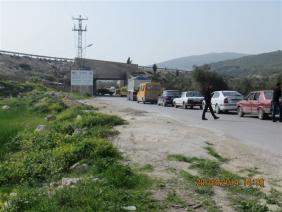
14:25 Huwwara Checkpoint – at the hitchhikers post on the way to Beracha settlement, a soldier stands guard. So, too, inside the watchtower facing the hitchhikers post at the exit from the settlement. At the checkpoint itself, the checking posts are unmanned. Two soldiers exit the checkpoint bound for the DCO base, probably at the end of their shift. On the other hand, at the checkpoint’s car park as well as in the fenced-in checkpoint itself which is empty at the moment, numerous vehicles are present, as well as tents and film crews (third photo).
One of them hurries to chase us away, forbidding me from taking pictures… The filmmakers (“The Stranger”) received the army’s permission to film there, and the film crew representative asks us not to make trouble… He says the soldiers and Palestinians on the ground are extras. Okay, in the virtual world in which we live, everything is equally possible and impossible.
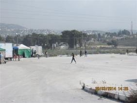
There are, however, real active checkpoints. They appear under the guise of ‘flying’ checkpoints (put up sporadically) but they turn out to be rather permanent. The occupiers’ cunning simply puts them up at changing times. Thus at the entrance to Burin village, under the bridge between Burin (second photo)
and Madama, as well as between Madame and Asira al Qibliya. (We have already seen and documented such an event: report from February 20, 2014 ). We stood there along with the vehicles and saw a car that was not permitted to pass under the bridge. The passengers, a man and woman wearing work overalls, who work together on a traffic project between Burin and Madama. They cannot understand why they were denied passage. The delay at this flying checkpoint lasts about an hour. In the late afternoon, the soldiers came back, and so did the checkpoint. As for the checkpoint at the entrance to Burin, we were informed that this happens on a daily basis.
Several cars showed photos of a martyr whose body was returned to the village of Asira al Qibliya very recently. It was buried temporarily in 2002, at a martyrs cemetery inside Israel.
15:25 Za'tara Junction Checkpoint (Tapuah) – Palestinian vehicle traffic lively, both coming from Nablus and from Ramallah, typical of Thursday afternoons. The checking posts at the checkpoint are unmanned. The watchtowers are. An army jeep parks in the checkpoint car park.
15:35 Checkpoint at the entrance to Kifl Harith village – army presence near the checkpoint. The barrier itself is open.
15:40 Oranit Terminal – in view of information received about forcing Palestinian passengers off Israeli buses a week ago Thursday, we passed there but did not see any workers who had been forced off the bus. Perhaps because today was not rainy (last week it was pouring).
15:45 Azzun Atme Checkpoint – workers return from Israel to the West Bank after a work week. No pressure.
'Azzun 'Atma
See all reports for this place-
'Azzun 'Atma
A Palestinian village of about 1,800 residents. The settlement of Sha'arei Tikva was established on its land adjacent to it, and the settlement of Oranit was established on its agricultural lands. By 2013, the separation fence had passed through the village and a checkpoint staffed by the army allowed the residents to cross from side to side. After building a massive wall surrounding the village and some of its agricultural lands, the residents went daily for five years to their lands that remained in the Seam Zone through the Oranit agricultural checkpoint (4). Since 2018 it has only opened during the olive harvest and the farmers have to pass daily at the Beit Amin / Abu Salman checkpoint (1447), about 3 kilometers north.From a report from March 24, 2021: "The farmers from Beit Amin and Azon Atma are happy that since February 21 the Oranit checkpoint .is going to be open 3 times a day, The farmers are really developing the place."
Report from July 14, 2024: "Ornit checkpoint is closed . The Beit Amin/Abu Salman agricultural checkpoint is closed (there is no contact with the military to check if it opens rarely), the Ezbat Jaloud checkpoint was opened once a day before the war.
Updated for July 2024
 Apr-11-2019Azoun: The main entrance to village blocked now for several weeks
-
Habla
See all reports for this place-
Habla CP (1393)
The Habla checkpoint (1393) was established on the lands of the residents of Qalqilya, on the short road that
connected it for centuries to the nearby town of Habla. The separation barrier intersects this road twice and cut off the residents of Qalqilya from their lands in the seam zone.(between the fence and the green line).
There is a passage under Road 55 that connects Qalqilya to the sabotage This agricultural barrier is used by the farmers and nursery owners established along Road 55 from the Green Line and on both sides of the kurkar road leading to the checkpoint.
This agricultural checkpoint serves the residents of Arab a-Ramadin al-Janoubi (detached from the West Bank), who pass through it to the West Bank and back to their homes. The opening hours (3 times a day) of this agricultural checkpoint are longer than usual, about an hour (recently shortened to 45 minutes), and are coordinated with the transportation hours of a-Ramadin children studying in the occupied in the West Bank. Nina SebaAug-18-2025Habla: The gate is in the process of closing
-
Huwwara
See all reports for this place-
The Huwwara checkpoint is an internal checkpoint south of the city of Nablus, at the intersection of Roads 60 and 5077 (between the settlements of Bracha and Itamar). This checkpoint was one of the four permanent checkpoints that closed on Nablus (Beit Furik and Awarta checkpoints to the east and the Beit Iba checkpoint to the west). It was a pedestrian-only barrier. As MachsomWatch volunteers, we watched therre since 2001 two shifts a day - morning and noon, the thousands of Palestinians leaving Nablus and waiting for hours in queues to reach anywhere else in the West Bank, from the other side of the checkpoint the destination could only be reached by public transport. In early June 2009, as part of the easing of Palestinian traffic in the West Bank, the checkpoint was opened to vehicular traffic. The passage was free, with occasional military presence in the guard tower. Also, there were vehicle inspections from time to time. Since the massacre on 7.10.2023, the checkpoint has been closed to Palestinians.
On February 26, 2023, about 400 settlers attacked the town's residents for 5 hours and set fire to property, such as houses and cars. Disturbances occurred in response to a shooting of two Jewish residents of Har Bracha by a Palestinian Terrorist. The soldiers stationed in the town did not prevent the arson and rescued Palestinian families from their homes only after they were set on fire. No one was punished and Finance Minister Smotrich stated that "the State of Israel should wipe out Hawara." Left and center organizations organized solidarity demonstrations and support actions for the residents of Hawara.Hawara continued to be in the headlines in all the months that followed: more pogroms by the settlers, attacks by Palestinians and a massive presence of the army in the town. It amounted to a de facto curfew of commerce and life in the center of the city. On October 5, 2023, MK Zvi established a Sukkah in the center of Hawara and hundreds of settlers backed the army blocked the main road and held prayers in the heart of the town all night and the next day. On Saturday, October 7, 23 The "Swords of Iron" war began with an attack by Hamas on settlements surrounding Gaza in the face of a poor presence of the IDF. Much criticism has been made of the withdrawal of military forces from the area surrounding Gaza and their placement in the West Bank, and in the Hawara and Samaria region in particular, as a shield for the settlers who were taking over and rioting.
On November 12, 2023, the first section of the Hawara bypass road intended for Israeli traffic only was opened. In this way, the settlers can bypass the road that goes through the center of Hawara, which is the main artery for traffic from the Nablus area to Ramallah and the south of the West Bank. For the construction of the road, the Civil Administration expropriated 406 dunams of private land belonging to Palestinians from the nearby villages. The settlers are not satisfied with this at the moment, and demand to also travel through Hawara itself in order to demonstrate presence and control.(updated November 2023)
. Shoshi AnbarMay-18-2025Huwara: The old houses in Area C
-
Kifl Harith
See all reports for this place-
Kifl Harith
This is a Palestinian located north-west of the settler-colony town of Ariel, 18 kilometers south of the city of Nablus. It numbers 3, 206 inhabitants, as of 2007. 42% of the village lands lie in Area B, and 58% in Area C. In 1978, some hundreds of dunams of the village’s farmland was sequestered in order to found the settler-colony of Ariel – in total 5,184 dunams from the Palestinian communities of Salfit, Iscaqa, Marda, and Kifl Harith. Dozens of square kilometers were also confiscated for paving road no. 5 as well as road 505 and their buffer zones, and the Israeli electricity company’s power station. Over the years the village has suffered harassment by sometimes-armed settler-colonists, even casualties. In 1968 the army’s rabbinate ruled the maqam site Nabi Yanoun (sanctified grave of the Prophet Yanoun) is in fact the tomb of Joshua, Son of Nun. Another structure in the village, named Nabi Tul Kifl by the Palestinians, has been identified by the Israeli authorities as to the tomb of Caleb, Son of Yefuneh. These sites are located in the heart of the village, near the mosque, and at times of Jewish religious festivities and pilgrimages, the center of the village is illuminated by projectors and thousands of Jews arrive, protected by hundreds of Israeli soldiers. During such a period, a night curfew is imposed on the village and the villagers are forced to stay shut inside their homes.
-
Za'tara (Tapuah)
See all reports for this place-
Za'tara (Tapuah) Za'tara is an internal checkpoint in the heart of the West Bank, at the intersection of Road 60 and Road 505 (Trans-Samaria), east of the Tapuah settlement. This checkpoint is the "border" marked by the IDF between the north and south of the West Bank, in accordance with the policy of separation between the two parts of the West Bank that has been in place since December 2005. At the Za'tara checkpoint, there are separate routes for Israelis and Palestinians. In the route for Israelis, there are no inspections and the route for Palestinians inspects. The queue lengthens and shortens suits. The checkpoint is open 24 hours a day. The checkpoint is partially staffed and the people who pass through it are checked at random.
 Shoshi AnbarSep-27-2023Za'atra (Tapuah Intersection). Signs
-