Beit Amin, Kufr Thulth
Kafr Thult
We visited the municipal building. The chairman had gone to Ramallah. We met with R., the financial director. He said usually there were no problems. Some farmers’ lands border on the settlement of Ma’aleh Shomron. Occasionally, when the atmosphere is tense, the settlement’s security coordinator gets jumpy and even threatens them with a weapon and chases them away. Once an army officer arrived and calmed things down. In such cases the farmers usually leave and return the next day. Sometimes the settlement’s security coordinator limits how long the farmers may stay.
60% of Thult’s inhabitants are teachers and functionaries, the rest are farmers or laborers who work in Israel.
It’s usually quiet. About two months ago there were problems with the army because youths threw rocks at soldiers.
Because of limits on construction, people risk building in Area C, mostly to the south. They were warned already four years ago but have built anyway and still live there. Young people don’t marry before they’re 30 because of housing shortages and economic conditions. But recently apartment buildings have been constructed for young people, south of the school. He says the building had a permit.
Thult’s farmers use the Jaloud agricultural gate to the west and also Bawwabat al Kharb, next to Ras Tira, which are close to their lands. These usually open on time, but only for a short period. People who don’t get there exactly on time find the gate locked. The gates are accessible during the olive harvest, which has already ended, and during the carob season in September-October. The usual complaints are that permits are issued to the landowner who may be already very old, and to a small child, who are unable to work the land. Because of such problems, or in the case of an old landowner who has died and left the land to his sons, but it isn’t registered in their names, they can’t obtain a permit to cultivate it and are forced to lease it to someone who does have one.
‘Izbet Salman (a joint municipality comprising Jaloud, ‘Izbet Salman, Askar and Al Mudawwar)
We met with Y.S., the secretary. Most of the lands of ‘Izbet Salman and Jaloud are on the other side of the fence. They have the same problems with permits described above. Many farmers leased their lands to persons with permits. 75% of the residents of the joint municipality are farmers, but they work in the settlements and in Israel because they can’t work their own land or that of others.
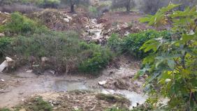
The gates serving them are Sha’arey Tiqwa and Barkan, which open for a short time, 10-15 minutes. ‘Izbet Salman suffers from the sewage flowing from Sha’arey Tiqwa. The pipe is frequently blocked and the sewage flows to the wadi. We are aware of the same problem in Bet Amin, located next to the same wadi. The stench in the summer is terrible. This summer they sprayed and covered the reservoir of drinking water next to ‘Izbet Salman.
Flying checkpoints have been set up in recent months at night, between Habla and Jaloud, which make it difficult for people coming from Qalqilya, Bidya and Ramallah.
On the way back we passed by Gate 1447 at 13:15.
It was closed.

‘Azzun ‘Atma
A tractor is working on the road, on behalf of the municipality, and four soldiers allow residents only to enter the village. The sewage still flows freely in the wadi near Bet Amin, the same as it did when we were here two weeks ago.
Bidya
A few multi-storey buildings under construction; the shops seem fairly busy.
At the exit to Highway 5, the sewage on one side of the road is channeled into a pipe, but still flows freely under the road to the other side.
Kufr Thulth
See all reports for this place-
Kufr Thulth is located in the western part of the West Bank, in the Qalqiliya district. According to archeological evidence, this village was inhabited as early as the Early Bronze Age. Findings have been dated there to Hellenistic, Roman, and Byzantine times. The village is situated on road 446, south of the Palestinian town of Azoun and north of Qanah River. It numbers 5,606 inhabitants as of 2017.
After the signing of the Oslo Accords, the built-up southern part of the village was categorized as Area B, comprising about 11% of its area, but nearly all of its farmland is classified as Area C.
Israel has confiscated 367 dunams of the village lands, and the area of neighboring village Arab Al Hula, in order to construct the settler-colonies of Karnei Shomron, Ginot Shomron, Ma’ale Shomron, and Immanuel, as well as the Separation Fence (splitting the village itself), and prevented villagers to access their farmlands lying near the settler-colonies. The authorities declared the area a nature reserve, and thus prevented access or any tending that would change the nature of the local land.
The Israeli army and the settler-colonists continue to harass the Palestinian farmers who visit their own lands, attack their herds and destroy trees and any other kind of farm crop, uproot trees and pollute water sources with sewage or toxic waste in order to make the Palestinians leave.
For further information: http://vprofile.arij.org/qalqiliya/pdfs/vprofile/kufrthulth_vp_en.pdf
-