Dura-Al Fawwar Junction, Hebron, Sansana (Meitar Crossing), South Hebron Hills
We left at 7 on a rainy and very cold morning.
The Sansana crossing’s parking lot is filled with cars. Sun, rain…you have to earn a living…so they go to work.
Heavy traffic all along Highway 60 to Hebron. The junctions are open. Children by the side of the road at the Al-Fawwar junction. Apparently UNRWA’s schools are open; they don’t have a winter break like the schools in the Palestinian Authority. We see no military presence.
The southern entrance to Hebron is also open, there’s truck traffic and the “balloon” is overhead. An army jeep parks on the side.
Fog covers the road as you approach Hebron-Kiryat Arba, and a police jeep next to the hitchhiking station keeps an eye on things. Farther along we see a large cloth banner. It turns out that Rami Kleinstein will perform in the Kirya.
Military vehicles in Hebron, in the alleys and the crossings. The Curve 160 checkpoint has an additional new IDF booth. There’s additional military presence in the area of the market, on Shuhada Street, even though it’s been deserted for years!
The Policeman’s Checkpoint is being rebuilt but there’s now only a pedestrian crossing, which makes it harder for the residents, and an announcement about the crossing, but only in Hebrew. The man with the donkey who used to bring milk to sell on the other side is no longer allowed to go through – the donkey isn’t a “pedestrian”…
The archaeological excavations at Tel Rumeida have spread in every direction and now include the area which the Palestinian residents who still live near there used to use as a detour. During Jordanian times British archaeologists excavated there and found the remains of a wall. Today the residents make a longer detour. No consideration is given to whether it’s convenient for them.
We met A., a member of the Abu Heikal family. They sued in an Israeli court to have returned to them a plot of land next to their home which they’d leased many years ago. A few years ago, without their knowledge, it had been leased to settlers, and for two years, because they hadn’t known, they continued to pay rent. The Civil Administration profited doubly.
The disputed plot, which has in the interim become part of the archaeological dig, is before the court. The family is represented by an inexperienced local attorney, and they say the Civil Administration and the settlers are represented by two very skilled lawyers. They have a feeling things are going against them and all is lost. The judge is focusing on why they didn’t obtain a lease document from the absent owner [It’s a complicated case of ownership that had changed hands and had apparently originally had belonged to Rabbi Bizau, the Chief Rabbi of Hebron before the 1929 pogrom – Haim Hanegbi’s grandfather], and didn’t publish an objection to the excavation in the Hebrew press [??!!]. The person we spoke to said they carried out that formal act years ago in an Arab newpaper, in their language.
We exchanged telephone numbers so we could stay in touch, and may be able to help a little.
Dura Al-Fawwar Junction
See all reports for this place-
Junction on Route 60: west - the town of El Dura, east - the Al Fawwar refugee camp. There is a manned pillbox at the junction. From time to time the army sets up flying checkpoints at the entrance to El Fawwar and Al Dura. Al-Fawwar is a large refugee camp (7,000 inhabitants in 2007) established in 1949 to accommodate Palestinian refugees from Be'er Sheva and Beit Jubrin and environs. There are many incidents of stone-throwing. In the vicinity of the pillbox there are excellent agricultural areas, Farmers set up stalls adjacent to the plots close to the road. In recent months the civil administration has set up dirt embankments thereby blocking access to the stalls, and making it impossible for the farmers to sell their vegetables. Updated April 2021, Michal T.
-
Hebron
See all reports for this place-
According to Wye Plantation Accords (1997), Hebron is divided in two: H1 is under Palestinian Authority control, H2 is under Israeli control. In Hebron there are 170,000 Palestinian citizens, 60,000 of them in H2. Between the two areas are permanent checkpoints, manned at all hours, preventing Palestinian movement between them and controlling passage of permit holders such as teachers and schoolchildren. Some 800 Jews live in Avraham Avinu Quarter and Tel Rumeida, on Givat HaAvot and in the wholesale market.
Checkpoints observed in H2:
- Bet Hameriva CP- manned with a pillbox
- Kapisha quarter CP (the northern side of Zion axis) - manned with a pillbox
- The 160 turn CP (the southern side of Zion axis) - manned with a pillbox
- Avraham Avinu quarter - watch station
- The pharmacy CP - checking inside a caravan with a magnometer
- Tarpat (1929) CP - checking inside a caravan with a magnometer
- Tel Rumeida CP - guarding station
- Beit Hadassah CP - guarding station
Three checkpoints around the Tomb of the Patriarchs
 Raya YeorDec-18-2025Hebron - Yusri Jaber and part of his family
-
Meitar checkpoint / Sansana
See all reports for this place-
Meitar Checkpoint / Sansana The checkpoint is located on the Green Line and serves as a border crossing between Israel and the West Bank. It is managed by the Border Crossing Authority of the Defense Ministry. It is comprised of sections for the transfer of goods as well as a vehicle checkpoint (intended for holders of blue identity cards, foreign nationals or diplomats and international organizations). Passing of Palestinians is prohibited, except for those with entry permits to Israel. Palestinians are permitted to cross on foot only. The crossing has a DCO / DCL / DCL / DCL (District Coordination Office), a customs unit, supervision, and a police unit. In the last year, a breach has been opened in the fence, not far from the crossing. This breach is known to all, including the army. There does not appear to be any interest in blocking it, probably as it permits needed Palestinian workers without the bureaucratic permits to get to work in Israel. Food stalls and a parking area economy have been created, but incidents of violent abuse by border police have also been recorded. Updated April 2022
-
South Hebron Hills
See all reports for this place-
South Hebron Hills
South Hebron Hills is a large area in the West Bank's southern part.
Yatta is a major city in this area: right in the border zone between the fertile region of Hebron and its surroundings and the desert of the Hebron Hills. Yatta has about 64,000 inhabitants.
The surrounding villages are called Masafer Yatta (Yatta's daughter villages). Their inhabitants subsist on livestock and agriculture. Agriculture is possible only in small plots, especially near streams. Most of the area consists of rocky terraces.Since the beginning of the 1980s, many settlements have been established on the agricultural land cultivated by the Palestinians in the South Hebron Hills region: Carmel, Maon, Susia, Masadot Yehuda, Othniel, and more. Since the settlements were established and Palestinians cultivation areas have been reduced; the residents of the South Hebron Hills have been suffering from harassment by the settlers. Attempts to evict and demolish houses have continued, along with withholding water and electricity. The military and police usually refrain from intervening in violent incidents between settlers and Palestinians do not enforce the law when it comes to the investigation of extensive violent Jewish settlers. The harassment in the South Hebron Hills includes attacking and attempting to burn residential tents, harassing dogs, harming herds, and preventing access to pastures.
There are several checkpoints in the South Hebron Hills, on Routes 317 and 60. In most of them, no military presence is apparent, but rather an array of pillboxes monitor the villages. Roadblocks are frequently set up according to the settlers and the army's needs. These are located at the Zif Junction, the Dura-al Fawwar crossing, and the Sheep Junction at the southern entrance to Hebron.
Updated April 2022
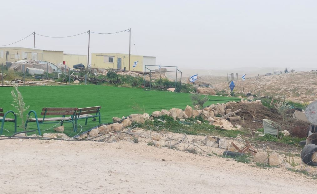 Michal TsadikFeb-17-2026Umm al-Khair: The soccer field for Palestinian children is surrounded by new trailers and lots of Israeli flags
-