Hebron - occupied city, closed on all sides to vehicle traffic
Purpose of the shift: To deliver donations to help families in the Jewish area of Hebron (H2), who have lost their source of income. The donations were collected by Rachel Afek.
Highway 60:
Meitar Crossing: Empty parking lots. For a year and a half now.
Samu: Surprise this week — the entrance from Highway 60 is open. Until now, everything was closed, and Samu had an entrance only from the north, from Karme.
Dahariya: Closed. Entry to Dahariya is only possible from the direction of Dura from the north. The entrance from Ramadin from the south is also closed.
Dura Al-Fawwar: Vehicle access to Dura was open when we passed. The policy: sometimes open, sometimes closed. No one knows when, how much, or why.
Hakvasim (Sheep) Junction, entrance to Hebron: closed to vehicles. Later it may have been open.
Summary of entrance policy to Palestinian communities along Highway 60: closed-open-closed. No one knows what to expect, reasons. It is impossible to schedule movement between communities. The exhaustion of life. It is impossible to avoid the obvious association with Yehuda Amichai’s book: Open-Closed-Open: even the fist was once an open palm and fingers.
Hebron:
Donations need to be transferred to Issa Amro, a brave Palestinian peace fighter from Hebron. Issa has a coupon system, which he issued with Palestinian groceries around and in the H2 area — the Jewish area of Hebron. In exchange for coupons, a family can purchase products from a predetermined list.
Hebron is an occupied city: only people identified with the regime, that is, Hebron settlers and their supporters, roam the streets.
I must be careful; Muhammad the Bedouin can’t just stand there. Issa Amro is afraid to walk around. It’s impossible to just meet Issa on the street. We agreed that I would take the footpath to the top of Tel Rumeida, which in its lower part reaches a spring that Hebron settlers took over and is marked with a kind of official trail marker. Muhammad will wait inside the Palestinian grocery store at the top of Tel Rumeida, opposite the settlement. I hide the stickers on my bag calling for an end to the war and begin to ascend. The road to the spring passes between the houses of Palestinian residents, and is still covered with graffiti saying, “Death to the Arabs.” They are probably afraid to erase, and maybe they have gotten used to it, maybe they don’t read Hebrew.
Issa’s house, at the top of the hill, is adjacent to the settlement. The balcony offers a spectacular view. The entire H2 area, and more. Just think of the tourism that could have been developed here in other times. Coffee with Issa and Muhammad, probably a relative who joins in. For a moment we forgot reality.
Issa says that Hebron is closed on all sides to vehicles. There is only one checkpoint in the direction of Tarqumiya, which is in a closed-open-closed status. Probably because of the mattress industry that markets it to Israel. In general, this policy blocks the development of Hebron, which is an industrial city.
Every evening there is a curfew starting at 9 PM, sometimes 10 PM. No one knows. Curfew means no leaving the houses. Only residents of Hebron are allowed to stay overnight — of course excluding Jews identified with the regime, that is, the settlers and their guests.
The house recently seized by Hebron settlers: The house is across the H2 area of Tel Rumeida, across the formidable yellow checkpoint behind the Chabad cemetery and kollel. The house was apparently purchased legally. The practical takeover was brutal. An elderly woman and her son’s family lived in the house. Towards evening, while the woman was out shopping for the Iftar meal, the settler buyers of the house entered. They took over the house, took (stole) some of the belongings, took over the roof, did not allow the woman to enter, and pushed the son’s family into a side room.
Expected future development: It is to be assumed that the checkpoint will be moved to include the new house within the controlled area, meaning that H2 will creep in, and additional Palestinian families around the house will be imprisoned within the Jewish area.
It is sad to admit that, in the current situation in the West Bank and Gaza, stories of creeping takeover of Palestinian property are being pushed to the bottom of public and journalistic interest.
Location Description
Hebron
See all reports for this place-
According to Wye Plantation Accords (1997), Hebron is divided in two: H1 is under Palestinian Authority control, H2 is under Israeli control. In Hebron there are 170,000 Palestinian citizens, 60,000 of them in H2. Between the two areas are permanent checkpoints, manned at all hours, preventing Palestinian movement between them and controlling passage of permit holders such as teachers and schoolchildren. Some 800 Jews live in Avraham Avinu Quarter and Tel Rumeida, on Givat HaAvot and in the wholesale market.
Checkpoints observed in H2:
- Bet Hameriva CP- manned with a pillbox
- Kapisha quarter CP (the northern side of Zion axis) - manned with a pillbox
- The 160 turn CP (the southern side of Zion axis) - manned with a pillbox
- Avraham Avinu quarter - watch station
- The pharmacy CP - checking inside a caravan with a magnometer
- Tarpat (1929) CP - checking inside a caravan with a magnometer
- Tel Rumeida CP - guarding station
- Beit Hadassah CP - guarding station
Three checkpoints around the Tomb of the Patriarchs
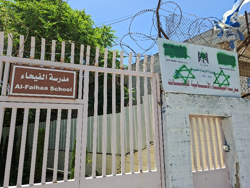 Lea ShakdielMay-27-2025Hebron, settlers vandalized the sign of the girls' school
-
South Hebron Hills
See all reports for this place-
South Hebron Hills
South Hebron Hills is a large area in the West Bank's southern part.
Yatta is a major city in this area: right in the border zone between the fertile region of Hebron and its surroundings and the desert of the Hebron Hills. Yatta has about 64,000 inhabitants.
The surrounding villages are called Masafer Yatta (Yatta's daughter villages). Their inhabitants subsist on livestock and agriculture. Agriculture is possible only in small plots, especially near streams. Most of the area consists of rocky terraces.Since the beginning of the 1980s, many settlements have been established on the agricultural land cultivated by the Palestinians in the South Hebron Hills region: Carmel, Maon, Susia, Masadot Yehuda, Othniel, and more. Since the settlements were established and Palestinians cultivation areas have been reduced; the residents of the South Hebron Hills have been suffering from harassment by the settlers. Attempts to evict and demolish houses have continued, along with withholding water and electricity. The military and police usually refrain from intervening in violent incidents between settlers and Palestinians do not enforce the law when it comes to the investigation of extensive violent Jewish settlers. The harassment in the South Hebron Hills includes attacking and attempting to burn residential tents, harassing dogs, harming herds, and preventing access to pastures.
There are several checkpoints in the South Hebron Hills, on Routes 317 and 60. In most of them, no military presence is apparent, but rather an array of pillboxes monitor the villages. Roadblocks are frequently set up according to the settlers and the army's needs. These are located at the Zif Junction, the Dura-al Fawwar crossing, and the Sheep Junction at the southern entrance to Hebron.
Updated April 2022
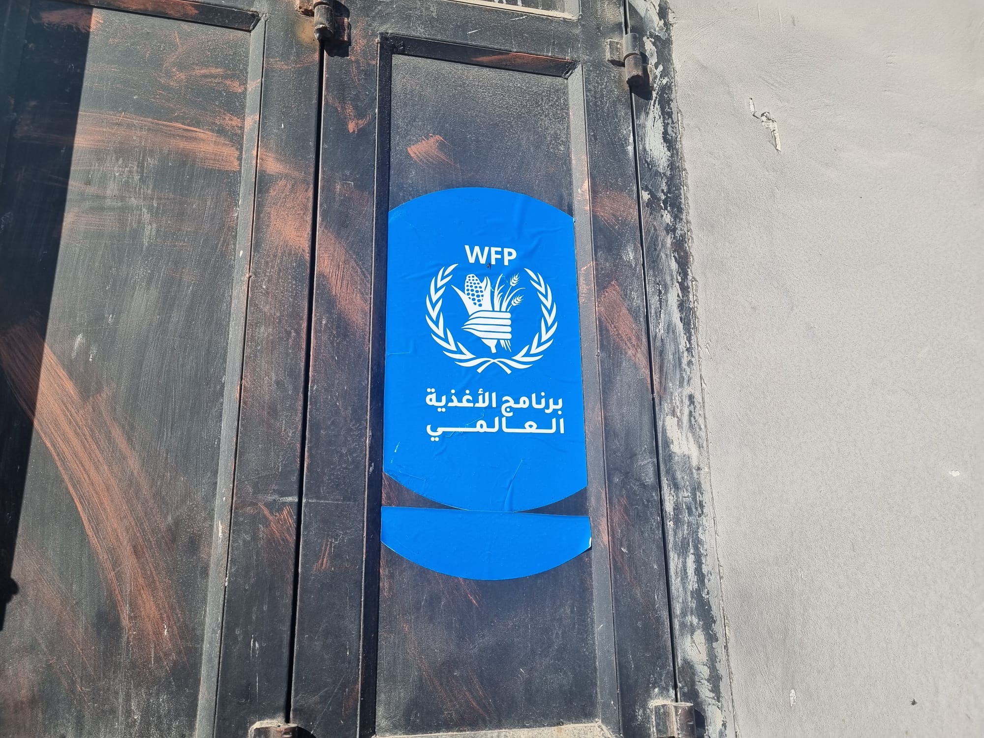 Smadar BeckerDec-14-2025A World Food Program (WFP) sticker at the entrance to a grocery store in Tuwani
-