Hebron, South Hebron Hills
South Hebron Hills
The dust covers all, and the routine today is grey not only metaphorically. The occupation proceeds with confidence.
Only in the Dir Razak area did we see cars driving in the wayward paths towards the main road. M., our sensitive driver, assumes there's trouble in Al Fawaar (otherwise, why does everyone come from here?). So we've asked… and indeed. The exit from Al Fawaar is blocked. Again, stone throwing event. This time, the soldiers didn't chase the throwers – who are usually mere kids – but simply blocked the yellow gate, adding on top of that an ID control check. Also next to the water well, we see many soldiers securing the locked up gate, but whoever wants to leave on his business, simply circumvents through those wayward routes, heading to Route 60, a few km south of the central exit.
Clumsiness, have we mentioned that already?
Hebron
In Hebron, it is now quiet again. The settlers go around, sticking signposts advertising Purim events and the distribution of sweets to the poor. How merciful they are, all of them there.
At all the other checkpoints and blockages, all as usual.
At the Tel Rumeida archeological site, too, they continue digging after yesteryears, meanwhile destructing the present and future of us all.
See more at: http://www.machsomwatch.org/reports/checkpoints/04/03/2014/morning/25503#sthash.nphPEed4.dpuf
Hebron
See all reports for this place-
According to Wye Plantation Accords (1997), Hebron is divided in two: H1 is under Palestinian Authority control, H2 is under Israeli control. In Hebron there are 170,000 Palestinian citizens, 60,000 of them in H2. Between the two areas are permanent checkpoints, manned at all hours, preventing Palestinian movement between them and controlling passage of permit holders such as teachers and schoolchildren. Some 800 Jews live in Avraham Avinu Quarter and Tel Rumeida, on Givat HaAvot and in the wholesale market.
Checkpoints observed in H2:
- Bet Hameriva CP- manned with a pillbox
- Kapisha quarter CP (the northern side of Zion axis) - manned with a pillbox
- The 160 turn CP (the southern side of Zion axis) - manned with a pillbox
- Avraham Avinu quarter - watch station
- The pharmacy CP - checking inside a caravan with a magnometer
- Tarpat (1929) CP - checking inside a caravan with a magnometer
- Tel Rumeida CP - guarding station
- Beit Hadassah CP - guarding station
Three checkpoints around the Tomb of the Patriarchs
 Raya YeorDec-18-2025Hebron - Yusri Jaber and part of his family
-
South Hebron Hills
See all reports for this place-
South Hebron Hills
South Hebron Hills is a large area in the West Bank's southern part.
Yatta is a major city in this area: right in the border zone between the fertile region of Hebron and its surroundings and the desert of the Hebron Hills. Yatta has about 64,000 inhabitants.
The surrounding villages are called Masafer Yatta (Yatta's daughter villages). Their inhabitants subsist on livestock and agriculture. Agriculture is possible only in small plots, especially near streams. Most of the area consists of rocky terraces.Since the beginning of the 1980s, many settlements have been established on the agricultural land cultivated by the Palestinians in the South Hebron Hills region: Carmel, Maon, Susia, Masadot Yehuda, Othniel, and more. Since the settlements were established and Palestinians cultivation areas have been reduced; the residents of the South Hebron Hills have been suffering from harassment by the settlers. Attempts to evict and demolish houses have continued, along with withholding water and electricity. The military and police usually refrain from intervening in violent incidents between settlers and Palestinians do not enforce the law when it comes to the investigation of extensive violent Jewish settlers. The harassment in the South Hebron Hills includes attacking and attempting to burn residential tents, harassing dogs, harming herds, and preventing access to pastures.
There are several checkpoints in the South Hebron Hills, on Routes 317 and 60. In most of them, no military presence is apparent, but rather an array of pillboxes monitor the villages. Roadblocks are frequently set up according to the settlers and the army's needs. These are located at the Zif Junction, the Dura-al Fawwar crossing, and the Sheep Junction at the southern entrance to Hebron.
Updated April 2022
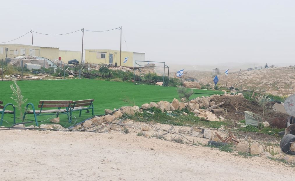 Michal TsadikFeb-17-2026Umm al-Khair: The soccer field for Palestinian children is surrounded by new trailers and lots of Israeli flags
-