Hebron, South Hebron Hills, Sun 28.11.10, Morning
Translator: Charles K.
Sansana-Meytar Crossing
We didn’t stop. We saw many laborers on the Israeli side, and no line on the Palestinian side.
Route 60
Below Beit Haggai, in front of the razor wire, a car and its passengers have been detained and are carefully inspected. A few minutes after our arrival they’re released. On the way back we saw a flying checkpoint at the entrance to Bani Na’im. A line of cars waited to be inspected.
Route 317
Today is the first time we’ve seen a flying checkpoint at the entrance to Kafr Zif. Five cars waited to be inspected by the Border Police. The jeep was parked in a manner that made entry very difficult for trucks. The owner of the grocery says that it’s been going on repeatedly since the permanent checkpoint was removed.
Hebron
All the checkpoints and entries are manned by the Kfir brigade. The magnemometer at the Pharmacy checkpoint has been repaired and children are occasionally inspected whenever it beeps for some reason or other. That’s what the checkpoint commander explained to us. He was willing to talk with us, and agreed (not an insignificant act!) to take a copy of the information sheet about Machsom Watch. A pleasant surprise. A squad of soldiers marched on Hebron’s “independent”, passing through the Pharmacy checkpoint.
We bought olive oil at a grocery in Hebron.
Hebron
See all reports for this place-
According to Wye Plantation Accords (1997), Hebron is divided in two: H1 is under Palestinian Authority control, H2 is under Israeli control. In Hebron there are 170,000 Palestinian citizens, 60,000 of them in H2. Between the two areas are permanent checkpoints, manned at all hours, preventing Palestinian movement between them and controlling passage of permit holders such as teachers and schoolchildren. Some 800 Jews live in Avraham Avinu Quarter and Tel Rumeida, on Givat HaAvot and in the wholesale market.
Checkpoints observed in H2:
- Bet Hameriva CP- manned with a pillbox
- Kapisha quarter CP (the northern side of Zion axis) - manned with a pillbox
- The 160 turn CP (the southern side of Zion axis) - manned with a pillbox
- Avraham Avinu quarter - watch station
- The pharmacy CP - checking inside a caravan with a magnometer
- Tarpat (1929) CP - checking inside a caravan with a magnometer
- Tel Rumeida CP - guarding station
- Beit Hadassah CP - guarding station
Three checkpoints around the Tomb of the Patriarchs
 Raya YeorDec-18-2025Hebron - Yusri Jaber and part of his family
-
South Hebron Hills
See all reports for this place-
South Hebron Hills
South Hebron Hills is a large area in the West Bank's southern part.
Yatta is a major city in this area: right in the border zone between the fertile region of Hebron and its surroundings and the desert of the Hebron Hills. Yatta has about 64,000 inhabitants.
The surrounding villages are called Masafer Yatta (Yatta's daughter villages). Their inhabitants subsist on livestock and agriculture. Agriculture is possible only in small plots, especially near streams. Most of the area consists of rocky terraces.Since the beginning of the 1980s, many settlements have been established on the agricultural land cultivated by the Palestinians in the South Hebron Hills region: Carmel, Maon, Susia, Masadot Yehuda, Othniel, and more. Since the settlements were established and Palestinians cultivation areas have been reduced; the residents of the South Hebron Hills have been suffering from harassment by the settlers. Attempts to evict and demolish houses have continued, along with withholding water and electricity. The military and police usually refrain from intervening in violent incidents between settlers and Palestinians do not enforce the law when it comes to the investigation of extensive violent Jewish settlers. The harassment in the South Hebron Hills includes attacking and attempting to burn residential tents, harassing dogs, harming herds, and preventing access to pastures.
There are several checkpoints in the South Hebron Hills, on Routes 317 and 60. In most of them, no military presence is apparent, but rather an array of pillboxes monitor the villages. Roadblocks are frequently set up according to the settlers and the army's needs. These are located at the Zif Junction, the Dura-al Fawwar crossing, and the Sheep Junction at the southern entrance to Hebron.
Updated April 2022
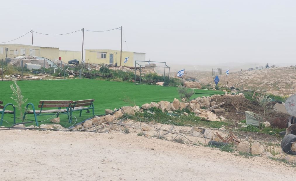 Michal TsadikFeb-17-2026Umm al-Khair: The soccer field for Palestinian children is surrounded by new trailers and lots of Israeli flags
-