South Hebron Hills: roadblocks all along the road that prevent anyone from entering or exiting the Palestinian towns
We drove past the Meitar Checkpoint early in the morning. There were army jeeps parked on both sides of the road and there were Israeli flags flying that had evidently been hung there by settlers after October 7th.
The entrance to Samoa was closed and the gate was locked. The entrances to Simia were also blocked with earth embankments, gravel, or boulders. There were roadblocks all along the road that prevented anyone from entering or exiting any of the Palestinian towns.

We managed to get to Farhan’s house after we found an opening. He told us about the difficulties they are experiencing every day. The residents are forced to create a new passage to the road every day in order to survive. Each time the army discovers the new break leading to the road they close it time after time.
There was little traffic on Route 60 and almost no cars with Palestinian license plates.
Dahariyya was blocked.

The entrance to Dura was blocked as well.
People with merchandise were crossing by foot from Dura to Al Fawwar while soldiers watched.
The following entrances were closed:
The southern entrance to Hebron
The entrance to Beit Hagai
Kalikas Junction: Soldiers were positioned on both sides of the road.
Hakvasim (sheep) Junction
There was an army jeep in the entrance to Bani Na’im and further on the entrance was closed.
Shuyukh junction – Hebron
Dura Al-Fawwar Junction
See all reports for this place-
Junction on Route 60: west - the town of El Dura, east - the Al Fawwar refugee camp. There is a manned pillbox at the junction. From time to time the army sets up flying checkpoints at the entrance to El Fawwar and Al Dura. Al-Fawwar is a large refugee camp (7,000 inhabitants in 2007) established in 1949 to accommodate Palestinian refugees from Be'er Sheva and Beit Jubrin and environs. There are many incidents of stone-throwing. In the vicinity of the pillbox there are excellent agricultural areas, Farmers set up stalls adjacent to the plots close to the road. In recent months the civil administration has set up dirt embankments thereby blocking access to the stalls, and making it impossible for the farmers to sell their vegetables. Updated April 2021, Michal T.
-
Meitar checkpoint / Sansana
See all reports for this place-
Meitar Checkpoint / Sansana The checkpoint is located on the Green Line and serves as a border crossing between Israel and the West Bank. It is managed by the Border Crossing Authority of the Defense Ministry. It is comprised of sections for the transfer of goods as well as a vehicle checkpoint (intended for holders of blue identity cards, foreign nationals or diplomats and international organizations). Passing of Palestinians is prohibited, except for those with entry permits to Israel. Palestinians are permitted to cross on foot only. The crossing has a DCO / DCL / DCL / DCL (District Coordination Office), a customs unit, supervision, and a police unit. In the last year, a breach has been opened in the fence, not far from the crossing. This breach is known to all, including the army. There does not appear to be any interest in blocking it, probably as it permits needed Palestinian workers without the bureaucratic permits to get to work in Israel. Food stalls and a parking area economy have been created, but incidents of violent abuse by border police have also been recorded. Updated April 2022
-
South Hebron Hills
See all reports for this place-
South Hebron Hills
South Hebron Hills is a large area in the West Bank's southern part.
Yatta is a major city in this area: right in the border zone between the fertile region of Hebron and its surroundings and the desert of the Hebron Hills. Yatta has about 64,000 inhabitants.
The surrounding villages are called Masafer Yatta (Yatta's daughter villages). Their inhabitants subsist on livestock and agriculture. Agriculture is possible only in small plots, especially near streams. Most of the area consists of rocky terraces.Since the beginning of the 1980s, many settlements have been established on the agricultural land cultivated by the Palestinians in the South Hebron Hills region: Carmel, Maon, Susia, Masadot Yehuda, Othniel, and more. Since the settlements were established and Palestinians cultivation areas have been reduced; the residents of the South Hebron Hills have been suffering from harassment by the settlers. Attempts to evict and demolish houses have continued, along with withholding water and electricity. The military and police usually refrain from intervening in violent incidents between settlers and Palestinians do not enforce the law when it comes to the investigation of extensive violent Jewish settlers. The harassment in the South Hebron Hills includes attacking and attempting to burn residential tents, harassing dogs, harming herds, and preventing access to pastures.
There are several checkpoints in the South Hebron Hills, on Routes 317 and 60. In most of them, no military presence is apparent, but rather an array of pillboxes monitor the villages. Roadblocks are frequently set up according to the settlers and the army's needs. These are located at the Zif Junction, the Dura-al Fawwar crossing, and the Sheep Junction at the southern entrance to Hebron.
Updated April 2022
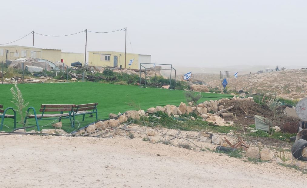 Michal TsadikFeb-17-2026Umm al-Khair: The soccer field for Palestinian children is surrounded by new trailers and lots of Israeli flags
-