South Hebron Hills, Sun 7.3.10, Morning
Translator: Charles K.
This is a report of a special shift we did today, Nurit, Muhammad our driver, and me.
We met Ehud Krinis from “The Village Group,” Hamad from OCHA and Ezara from Ta’ayush.
The tour was made possible by a 4×4 that Nurit obtained from her kibbutz.
The msafer are the borderlands around Yatta. They’re located southeast of the settlements of Carmel, Ma’on and outposts like Mizpeh Ya’ir. It’s a difficult desert region where Bedouin who were expelled in 1948 from the area of Arad and residents of Yata who came dozens of years ago for pasture live mainly in caves. 
For many years the IDF has been trying to expel them, claiming that the area is a firing range. From what we could see, it looks like an area that’s wide open, and other than malice and intentional neglect, there’s nothing there. Since the landscape is so harsh, an ordinary vehicle can’t get through, even though eight roadblocks were recently removed. That’s why we’re able to get there only infrequently, if and when our contacts notify us that the roadblocks were reestablished or that the IDF has made it even more difficult for the residents of the area.
Since Ehud, from the Villlages Group, described our tour, and the conditions of the Msafer so well, I've add only this to his report, quoted verbatim, below.
Written by: Michal, Machsom Watch
In a joint initiative of the Villages Group and Machsom Watch South, we went today on a tour of the Yatta msafer, the heart of the cave region in the southern Hebron hills. Hamad, from OCHA, and Ezra, from Ta’ayush, were our guides.
As we noted in our reports from last year – http://villagesgroup.wordpress.com/2008/12/15/blocking-the-roads-in-massafer-yatta-jinba – the msafer localities have for the past two years been subjected to intense pressure from the Israeli army, expressed, among other things, by many roadblocks made of piles of earth along the main roads connecting the msafer’s localities, as well as continual harassment by military vehicles of people from the Hebron area driving on the roads hoping to find work in Israeli localities in the Negev. Unusually, during our tour there were no signs of the army, perhaps in honor of the first appearance of Machsom Watch women in this region, a fact that was fully taken advantage of by the unending traffic of the job seekers’ Subarus – something now weighing down the permanent residents of the masafer. 
The roadblocks were open – a sign that the legal struggle to open them, conducted by Atty. Limor Yehuda from the Organization for Civil Rights, has for now borne fruit. At the same time, the condition of the unpaved road serving as the main artery for this area is quite bad, and in a number of places (as can be seen in the attached photographs) is almost completely impassable, even for a 4×4 vehicle.
The tour brought us to the elementary school (grades 1-4, 42 pupils) which opened this year in Pahit, in the heart of the msafer. The photos we took say it all: other than the good intentions of the relief organizations that made the school's opening possible, the infrastructure they provided – a few tents, chairs and blackboards, and toilets – is so minimal and meager that today, some five months after it was opened, weather damage has made the place completely unusable. It wouldn’t be an exaggeration to say that nowhere in our area (the entire Middle East) is a school forced to operate in such difficult conditions. But even so, the pupils continue to attend (though not when we visited),  transported by the vehicle bought recently with donations that we helped obtain.We are grateful to Michal and Nurit, from Machsom Watch South, who came on the tour, and hope that from now on the msafer region will be a regular stop on the map of this important organization.
Written by Ehud, from the Villages Group
South Hebron Hills
See all reports for this place-
South Hebron Hills
South Hebron Hills is a large area in the West Bank's southern part.
Yatta is a major city in this area: right in the border zone between the fertile region of Hebron and its surroundings and the desert of the Hebron Hills. Yatta has about 64,000 inhabitants.
The surrounding villages are called Masafer Yatta (Yatta's daughter villages). Their inhabitants subsist on livestock and agriculture. Agriculture is possible only in small plots, especially near streams. Most of the area consists of rocky terraces.Since the beginning of the 1980s, many settlements have been established on the agricultural land cultivated by the Palestinians in the South Hebron Hills region: Carmel, Maon, Susia, Masadot Yehuda, Othniel, and more. Since the settlements were established and Palestinians cultivation areas have been reduced; the residents of the South Hebron Hills have been suffering from harassment by the settlers. Attempts to evict and demolish houses have continued, along with withholding water and electricity. The military and police usually refrain from intervening in violent incidents between settlers and Palestinians do not enforce the law when it comes to the investigation of extensive violent Jewish settlers. The harassment in the South Hebron Hills includes attacking and attempting to burn residential tents, harassing dogs, harming herds, and preventing access to pastures.
There are several checkpoints in the South Hebron Hills, on Routes 317 and 60. In most of them, no military presence is apparent, but rather an array of pillboxes monitor the villages. Roadblocks are frequently set up according to the settlers and the army's needs. These are located at the Zif Junction, the Dura-al Fawwar crossing, and the Sheep Junction at the southern entrance to Hebron.
Updated April 2022
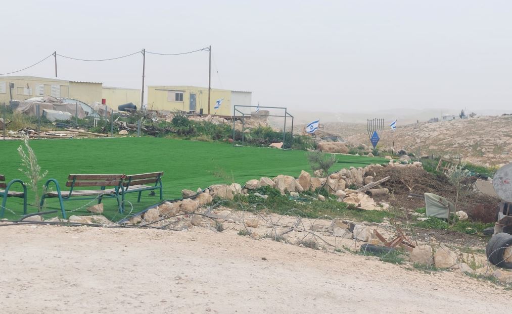 Michal TsadikFeb-17-2026Umm al-Khair: The soccer field for Palestinian children is surrounded by new trailers and lots of Israeli flags
-