Luban a-Sharqiya: the economic distress growing since the outbreak of the war

In previous shifts we documented the economic distress growing since the outbreak of war throughout the West Bank especially because of movement restrictions. For example, in Sinjila the army closed off a farmland of 110,000 dunams that the source of livelihood of 250 families. Fields are tended but inaccessible. In addition, townspeople normally working in other localities of the West Bank cannot reach their workplaces because exits from the town are blocked by the army often and arbitrarily so they are fired and lose their livelihood.
We also reported that, as in Azzun Atme, farmers in villages of the Western part of the West Bank close to the Separation Barrier also lost their livelihood. They too cannot reach their lands in the Seam Zone, the agricultural gates are closed and permits that were valid for a year or two have ben annulled.
This time we visited Luban a-Sharqiya where family have reached poverty level, for 1,200 out of 3,000 villagers who worked in Israel until October 7th are out of work, permits have been annulled and no passage to Israel is allowed.
We did plan to drive to Huwarra and Beita as well, where we had made appointments ahead of time to hear about the dire situation following attacks by colonists and the army. Due to bad timing, the assassination of Haniya during the previous night, Mustafa was asked not to arrive for fear of riots. We decided to go to Yasouf village where we had been several times in the past, including its town council. We drove along road 5, and since this was Tair’s first shift, we received explanations from Mustafa, our expert on the ground, all the way- beginning with the gap between Rosh Ha-Ayin south of the road and Kafr Qassem on the north because of the state laws, development possibilities of industrial zones and research and hi tec parks. Kafr Qassem simply cannot receive permits for this, and cannot change the status of its farmland as has Rosh Ha-Ayin. A bit after crossing the Green Line, we pass Shomron Checkpoint and continue along the new, wide Road 5 that was paved so that it is now impossible to reach the villages of Masha, Bidia, Sarta or A-Zawiya on its two sides. Mustafa emphasized that the large industrial zones of Ariel and Barqan colonies are spread over numerous kilometers before Ariel, over all hills north and south of the road. He also shows the huge car park for Palestinians working in these industries but not allowed to reach them by car. The car-park seems full, so we suppose that at least these workers are still managing to earn their living.
We continue eastward on Road 505 while on the hills, along many kilometers, the numerous buildings of Ariel are seen. We pass Marda village, and see the expanding colonies, outposts and army bases.
At Za’tara Junction (Tapuach) we turn on Road 5051 leading to Tapuach settlement and Yasouf village and find it blocked several dozen meters after the entrance to Tapuach. Another blockage of Yasouf makes it difficult for its inhabitants to reach the junction and Road 60 easily, the main traffic thoroughfare of the West Bank.
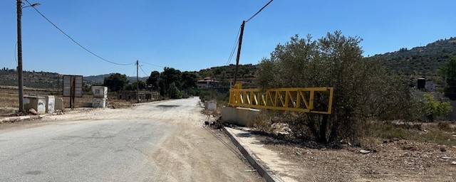
We gave up trying to visit Yasouf for the very long track to the southern entrance crosses an area forbidden to us, as Mustafa explained. We continued on Road 5 to Luban a-Sharqiya. At the entrance, on the road between Road 60, we saw the familiar yellow gate that enables the army to arbitrarily disconnect the village from its surrounding.

“You got here on the worst day of the last ten bad months, I swear!” This is how Amne welcomed us in good English, owner of a small, well-tended sweet shop at the entrance to the village. (Details of the village in our report of a year ago). Amne talks about the dire situation: for the past ten months most villagers have no source of livelihood, for the 1,200 (of 3,000 inhabitants) who used to work inside Israel cannot reach it any more. Lately, several women did find work in tomato harvest in the nearby settlements (Rechelim, Levona and Eli, who were also hostile in the past). Five began, and their number has already risen to 15, and they hope to increase that number for one needs to live… She sits for hours in the shop, people have no money for luxuries, hardly even for basic commodities.
During our whole stay, one single child entered and bought a sweet for a single shekel. The 300 shekels at the end of month hardly cover expenses. We were joined by her nice 8-year-old daughter who knows a few words in English. Apparently her maternal great grandmother, an American, came to visit and be with Amne’s mother who is a cancer patient. None of the family members is allowed to accompany the patient to her treatments in Jerusalem.
School children too have suffered during this entire school year. The secondary schools are beyond the yellow barrier in the direction of Road 60, and often for many days the army has closed the barrier and forbade exiting the village.
Another difficult problem is the lack of water. They receive water only from Mekorot (Israeli water company) and the allotment is hardly sufficient, sometimes they have no water for days running. Along the way to Road 60 lies a vast farmland with fields that are not growing a thing because of the lack of water. The farmers have had to find another source of livelihood.
We went home sad…
Location Description
Yasuf
See all reports for this place-
Yasuf The village numbers 2,500 residents, and in the neighboring village of Iskaka about 1,500. Yasuf suffers from low water supply and intermittent flow - although the population has more than doubled since the Oslo Accords, the 12 cubic meters set in 1996, sometimes even less, are alternated between the two villages, summer and winter .Permits to complete the harvest are only given for a few days, and there are often roadblocks on the way to the groves and the settlers, mostly fr/om Tapuah, try to drive the harvesters away. Since 2006, the settlements have been expanded threefold from their original location, and the harassments are numerous - including vandalism of cars and spraying of hate-inscriptions on the mosque. The settlers from Kfar Tapuach took control of land belonging to the residents and planted their own trees, and the army does not allow the villagers to approach these plots.
-
Za'tara (Tapuah)
See all reports for this place-
Za'tara (Tapuah) Za'tara is an internal checkpoint in the heart of the West Bank, at the intersection of Road 60 and Road 505 (Trans-Samaria), east of the Tapuah settlement. This checkpoint is the "border" marked by the IDF between the north and south of the West Bank, in accordance with the policy of separation between the two parts of the West Bank that has been in place since December 2005. At the Za'tara checkpoint, there are separate routes for Israelis and Palestinians. In the route for Israelis, there are no inspections and the route for Palestinians inspects. The queue lengthens and shortens suits. The checkpoint is open 24 hours a day. The checkpoint is partially staffed and the people who pass through it are checked at random.
 Shoshi AnbarSep-27-2023Za'atra (Tapuah Intersection). Signs
-