
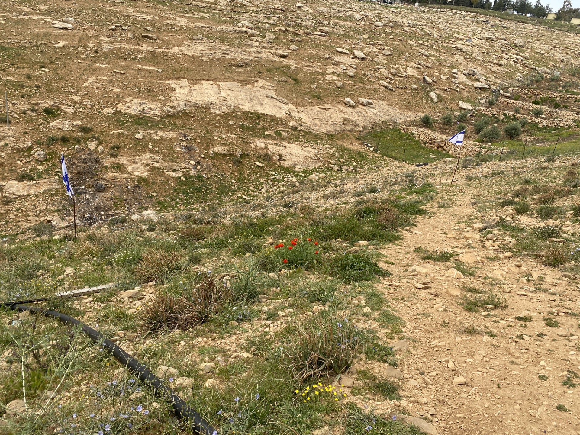
התנחלות כרמל מטילה מצור על תושבי אום אל ח'יר באמצעות הקפתו במבנים
מחסום מיתר – כ-20 מכוניות פרטיות בחנייה. אולי מעידות על כמה פלסטינים בעלי אישור כניסה לארץ?
כביש 317
מאזור התעשיה עומרים לכל אורך הדרך הוצבו דגלי ישראל כדי להישאר גם אחרי יום העצמאות. הדגלים הללו מקדמים גם את הבאים לאום אל ח’יר. הם מוצבים על בריכת המים, לאורך הכביש אל מבני הציבור של הכפר ואיפה לא.
הגבעות ירוקות, עשב טרי ורענן אך כמעט ואין עדרים של פלסטינים, רק עדר פרות של ינון רועה באדמות זנותא הזנוחה
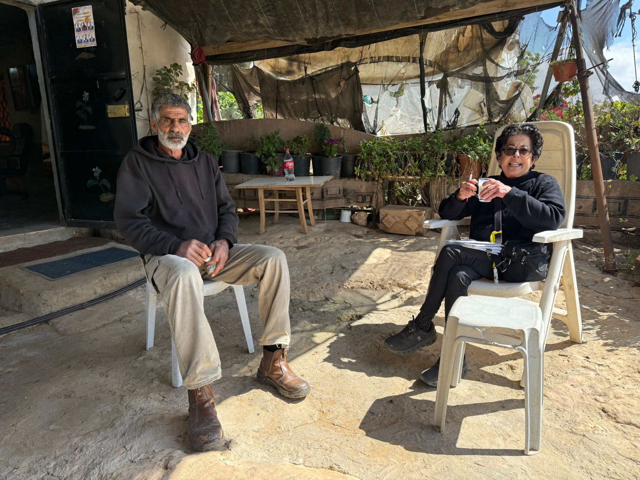
אום אל ח’יר
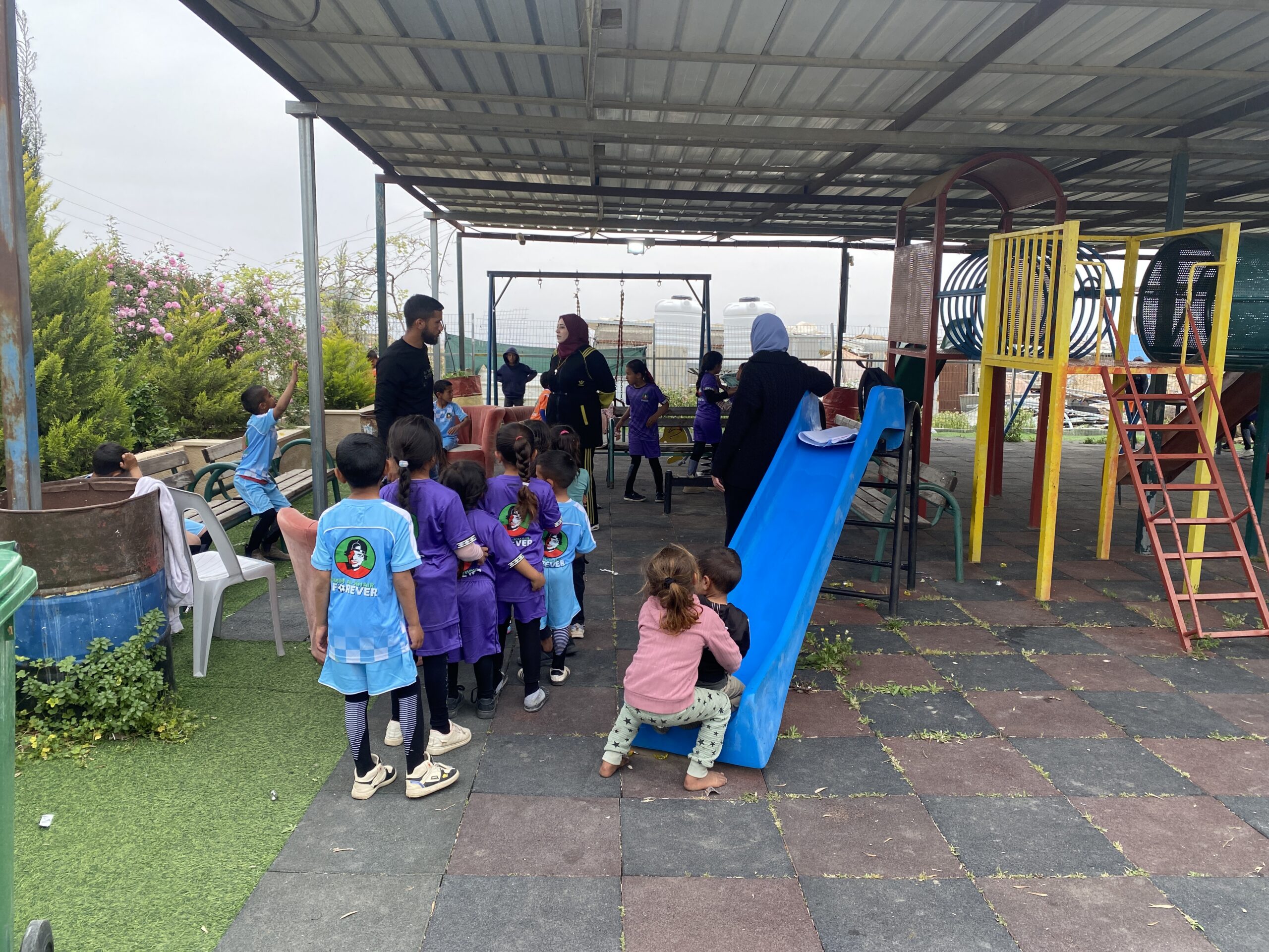
במתחם המועצה מתקיימת פעילות לימודית לילדי גן-בי”ס כי הילדים לא הולכים לבית הספר. נקראנו לדווח על ההתפתחויות החדשות במקום, שמזלן הרע נגרם מהשתלטות ההתנחלות כרמל על כל הסביבה. ח’ליל ראש המועצה ועיד מסבירים לנו את המצב:
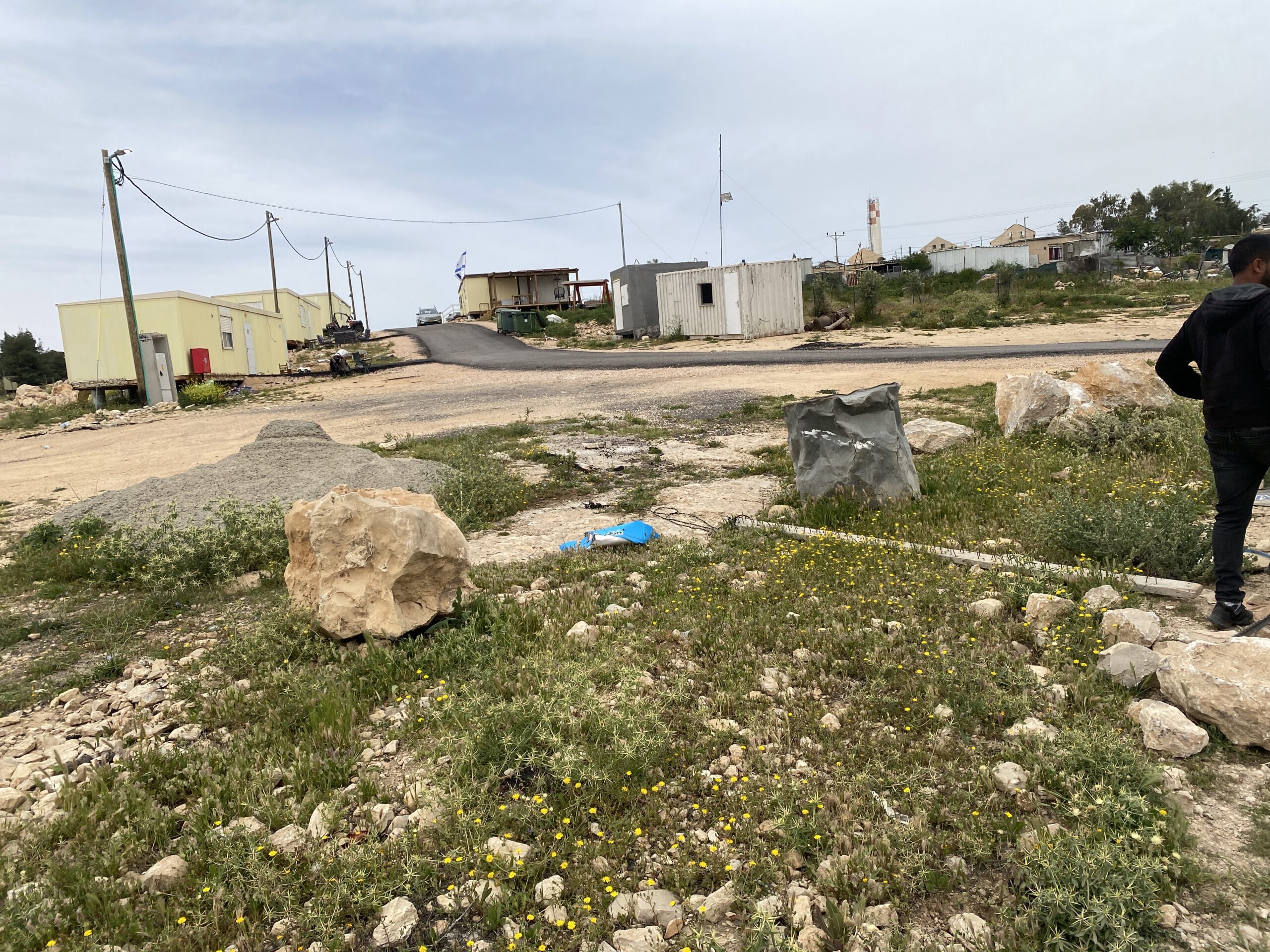
במהלך המלחמה לכפר לא היה כל מיגון בעוד לחמשת הקרוואנים החדשים שהציבו אנשי כרמל ממש בצמידות לבתי הכפר, הובאה מיגונית.
צוות צילום אוסטרלי שזימן ראש המועצה לתעד את המצב בעת המלחמה הותקף ע”י הרבש”צ נבו מכרמל, שטען כי זאת פעילות פוליטית אסורה. בכל התקופה מוסדות החינוך שבתו וכך גם המרפאה שלידן, ולכן כולם מאוד שמחו כאשר ביום שני האחרון (13.4) נפתחו בתי הספר.
להפתעתם הסתבר כי על כביש האספלט המוביל למוסדות הציבור הוקם מחסום חביות ואבנים שנסגר כל ערב ונפתח חלקית בבקר – פעילותם של נערי הגבעות מכרמל, ואילו שביל העפר היורד מהכפר אל הואדי ומצטרף לכביש מעבר למחסום, נחסם בגדר תיל התחומה משני הצדדים בדגלי ישראל המוכיחים משילות.
תושבי אום אל ח’יר הזעיקו את המשטרה, הצבא הגיע ובתגובה להתקהלות התלמידים פיזר עליהם גז מדמיע וגרם לבהלה כללית. מאז 55 הילדים של הישוב נצורים בו ולא יוצאים ללימודים. והמחסומים גם מקשים על התושבים להגיע אל המסגד ואל המרפאה הנמצאים כולם לאורך אותו כביש.
המנהל האזרחי הוזעק למצוא פתרון לבעיה, ובדיונים מול המשטרה, ללא שיתוף התושבים, הגיעו לפתרון שהצבא ילווה את התלמידים בדרכם לבית הספר, לאורך כביש האספלט. ההצעה אינה מקובלת על תושבי אום אל ח’יר – החיילים הם יחידות הגמ”ר שאין להם כל כוונה להגן על תושבי הכפרים.
הפתרון שמציע ראש המועצה הוא הסדרת תחבורה ציבורית, אוטובוסים, שיסיעו את הילדים הלוך ושוב לבית הספר ובאותם זמנים ישרתו גם את הנשים היוצאות אל המרפאה. התבקשנו לסייע להם להשיג תקציב למימון האוטובוסים.
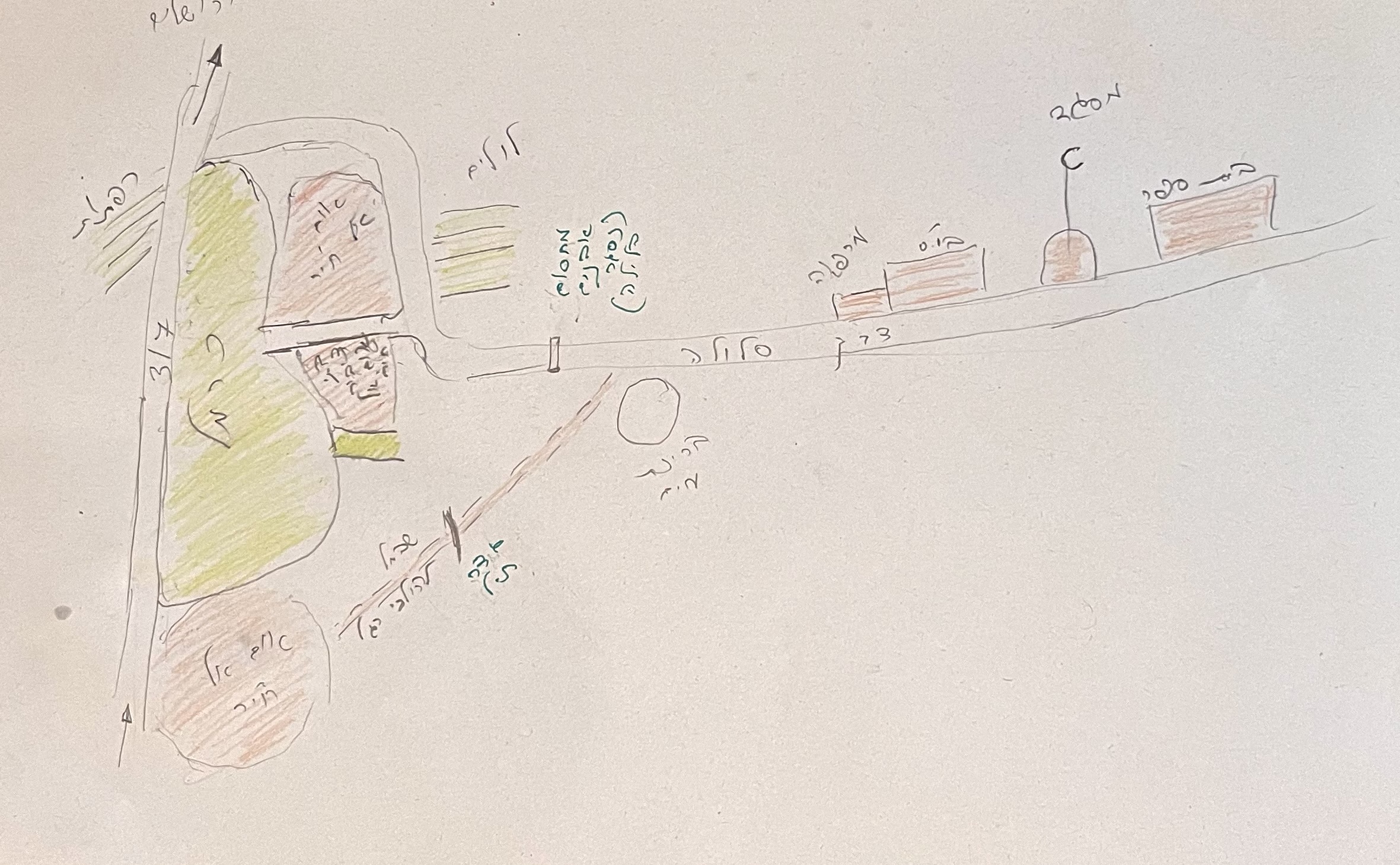
התרשים מבהיר את המצור שמטיל הישוב כרמל על תושבי אום אל ח’יר באמצעות הקפתו במבנים, וחסימת דרכי היציאה.
כביש 60
בזמן המלחמה היו כל המחסומים בכניסות לישובים מהכביש סגורים. השבוע הם נפתחים לפחות חלקית:
בצומת הכבשים נפתח המחסום לכיוון חברון אך סגור לכיוון יטא.
בצומת דורא – אל פוואר פתוח לכיוון אל פוואר ובדורא נצפו חיילים שאולי פותחים גם שם.
תנועה ערה של מכוניות נצפתה לכל אורך הכביש וגם במחסום.
Location Description
Dura Al-Fawwar Junction
See all reports for this place-
Junction on Route 60: west - the town of El Dura, east - the Al Fawwar refugee camp. There is a manned pillbox at the junction. From time to time the army sets up flying checkpoints at the entrance to El Fawwar and Al Dura. Al-Fawwar is a large refugee camp (7,000 inhabitants in 2007) established in 1949 to accommodate Palestinian refugees from Be'er Sheva and Beit Jubrin and environs. There are many incidents of stone-throwing. In the vicinity of the pillbox there are excellent agricultural areas, Farmers set up stalls adjacent to the plots close to the road. In recent months the civil administration has set up dirt embankments thereby blocking access to the stalls, and making it impossible for the farmers to sell their vegetables. Updated April 2021, Michal T.
-
Hakvasim (sheep) Junction
See all reports for this place-
One of the roadblocks (earthworks, rocks, concrete blocks or iron gates) that prevent transit of vehicles to Route 60 in the southern West Bank and block the southern entrance to Hebron. A manned pillbox supervises the place.
-
Meitar checkpoint / Sansana
See all reports for this place-
Meitar Checkpoint / Sansana The checkpoint is located on the Green Line and serves as a border crossing between Israel and the West Bank. It is managed by the Border Crossing Authority of the Defense Ministry. It is comprised of sections for the transfer of goods as well as a vehicle checkpoint (intended for holders of blue identity cards, foreign nationals or diplomats and international organizations). Passing of Palestinians is prohibited, except for those with entry permits to Israel. Palestinians are permitted to cross on foot only. The crossing has a DCO / DCL / DCL / DCL (District Coordination Office), a customs unit, supervision, and a police unit. In the last year, a breach has been opened in the fence, not far from the crossing. This breach is known to all, including the army. There does not appear to be any interest in blocking it, probably as it permits needed Palestinian workers without the bureaucratic permits to get to work in Israel. Food stalls and a parking area economy have been created, but incidents of violent abuse by border police have also been recorded. Updated April 2022
-
South Hebron Hills
See all reports for this place-
South Hebron Hills
South Hebron Hills is a large area in the West Bank's southern part.
Yatta is a major city in this area: right in the border zone between the fertile region of Hebron and its surroundings and the desert of the Hebron Hills. Yatta has about 64,000 inhabitants.
The surrounding villages are called Masafer Yatta (Yatta's daughter villages). Their inhabitants subsist on livestock and agriculture. Agriculture is possible only in small plots, especially near streams. Most of the area consists of rocky terraces.Since the beginning of the 1980s, many settlements have been established on the agricultural land cultivated by the Palestinians in the South Hebron Hills region: Carmel, Maon, Susia, Masadot Yehuda, Othniel, and more. Since the settlements were established and Palestinians cultivation areas have been reduced; the residents of the South Hebron Hills have been suffering from harassment by the settlers. Attempts to evict and demolish houses have continued, along with withholding water and electricity. The military and police usually refrain from intervening in violent incidents between settlers and Palestinians do not enforce the law when it comes to the investigation of extensive violent Jewish settlers. The harassment in the South Hebron Hills includes attacking and attempting to burn residential tents, harassing dogs, harming herds, and preventing access to pastures.
There are several checkpoints in the South Hebron Hills, on Routes 317 and 60. In most of them, no military presence is apparent, but rather an array of pillboxes monitor the villages. Roadblocks are frequently set up according to the settlers and the army's needs. These are located at the Zif Junction, the Dura-al Fawwar crossing, and the Sheep Junction at the southern entrance to Hebron.
Updated April 2022
 Muhammad D.Apr-21-2026Daphna with Azzam in Susiya
-
Umm al-Khair
See all reports for this place-
Umm al-Kheir
A Palestinian village in the southern Hebron governorate, populated by five families. The Palestinian residents settled there decades ago, after Israel expelled them from the Arad desert and purchased the land from the residents of the Palestinian village of Yatta. The village suffers from the violence of nearby Carmel settlers, from water shortage and is subject to frequent demolition of buildings by the Civil Administration.
-
Zanuta
See all reports for this place-
Zanuta was a small rural Palestinian locality until its demolition. It was situated in the space around the town Dahariya in the South Hebron Hills, about a ten-minute ride from Meitar Checkpoint. There are documented remains of a large Byzantine settlement in the area. Since the Ottoman (Turkish Empire) period (1516-1917) Zanuta was documented as a locality of shepherds and farmers who live in the remains of the ancient structures and the residential caves near them.
Two individual ranches of colonists were created next to Zanuta: Meitarim (of the colonist Yinon Levi) to the east, and Yehudah (of the colonist Elyashiv Nachum) to the north. Endless attacks, harassments and attempt to chase away the Zanuta villagers have originated in these two outposts.
Until the expulsion, four families lived in the village: A-Samama, Al-Tel, Al Batat, and Al-Qaisia. Farming constituted their main economic activity and employed most of the villagers. The total area of the village is about 12,000 dunams, of which about 3,000 are tended, mostly with field crops.
This village has never had a master plan that would legitimize construction permits. The Civil Administration claimed it was too small and the distance to the next town, Dahariya, too great. For this reason, the Israeli authorities pressured the villagers to leave. The colonists did the job for them.
-