
A tour of checkpoints and enclaves in North Jerusalem


Tour of checkpoints and enclaves north of Jerusalem
August 22, 2021
Natanya Ginsburg, Kamal, Anat Tueg (reporting), Ronit Ramati-Dahan, (photos), Tal H. translation
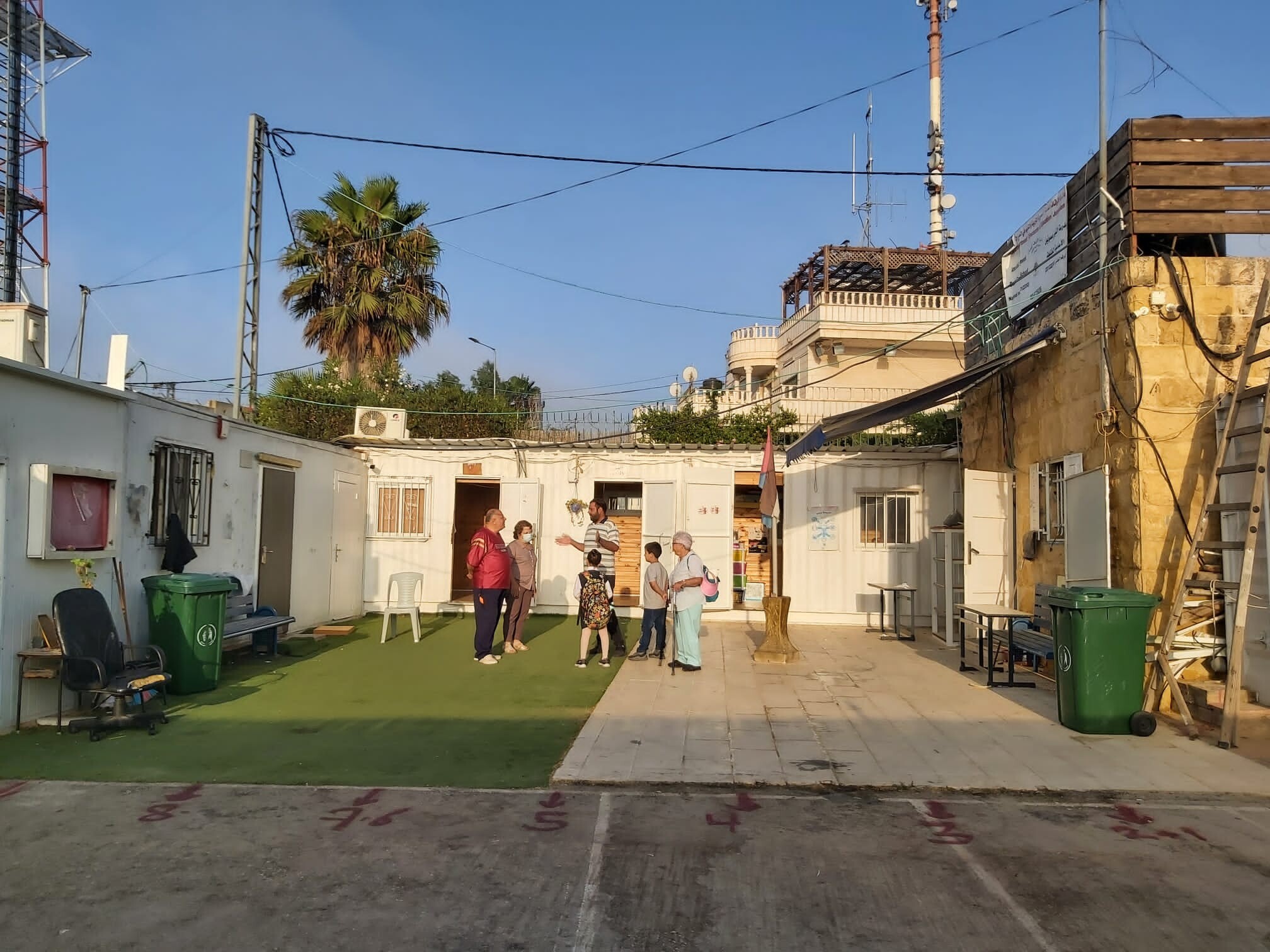
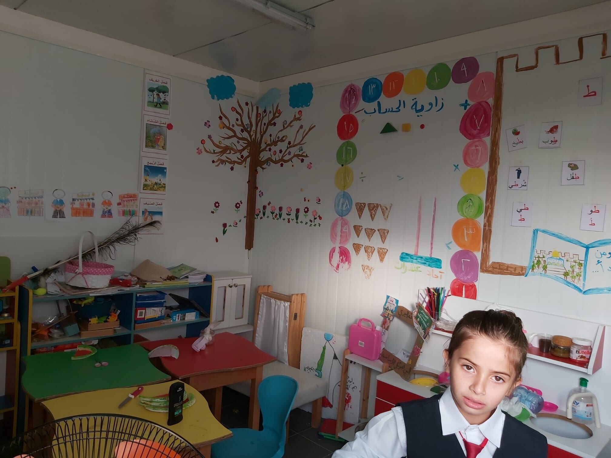
7:00 Elementary school at Nabi Samauil, short tour of Shmuel Mountain Checkpoint and the house caged inside New Giv’on
70 school children from kindergarten age until 9-years-old living in Nabu Samauil and the village of Halaila between Giv’on and New Giv’on attend the schoolhouse. The janitor has arrived with his son and daughter, who study at this school. The structures are small prefabs, and the children ran and opened all the doors, proudly showing us the tiny class rooms that hardly contain the chairs and tables. There are 13 teachers, mostly from Jerusalem, and the curriculum comes from the Palestinian Authority (there’s a Palestine flag hanging in the kindergarten). In spite of the harsh conditions, apparently the school is doing a good job. The janitor spoke of people’s hardships, where they cannot tend their fields or construct, and any building taking place is immediately destroyed. Material about Nabi Samauil is present on our website.
On our way to Al Jib we cross the closed gate near the settler-colony of Mount Shmuel. The checkpoint blocks the road that used to lead to the farm lands of Nabi Samauil and other villages. Luckily there is a hole in the fence that enables one to cross it on foot. We drove to Giv’on to show Ronit the house caged inside fences in New Giv’on. The only opening is a checkpoint leading to the mother-village of Beit Ighza. Apparently, the settler-colonists living in their large and well-tended colony could not give up even a tiny piece of land that would enable the house to be included in Beit Ighza itself.
The Bidou enclave, Beit Iksa checkpoint, and back through the Bir-Naballah /Rafat Checkpoint to Qalandiya and Jab’a
We crossed the Al Jib Checkpoint to the Bir Naballah enclave. There we drove to the lower road (‘fabric of life’) – which is the only track connecting the Bidou enclave and the nearby villages (on pnrinciple this is Area C, while the villages themselves are Area B. The soldiers, though, think this is all Area A). Bidou looks lively – which is delightful – although it has lost its numerous Israeli customers. Finally we reached the checkpoint that prevents access from the enclave villages to Beit Iksa. Oly the inhabitants of Beit Iksa are allowed through. Another village under siege.
We returned to the Bir Naballah enclave, whose many Jerusalemite residents deserted as soon as it was surrounded by a fence on all sides. We drove then to the lower road that connects to Rafat village. We continued on the winding road to Kufr Aqab, Qalandiya and Jab’a. On our way we looked at Qalandiya Checkpoint. Even at this hour there were waiting lines at the entrance and vehicle traffic was practically at a standstill. There were bulldozers seen in the army base next to the checkpoint on the east, as works on the lower road have begun, where eventually only settler-colonists and Israelis will be allowed to travel without stopping at Qalandiya or Hizma checkpoints, and from there enjoy a rapid connection to road 443.
Hizma, Anatot, apartheid road 4370 through an Israelis-only checkoint, and back to Jerusalem through Issawiya
Hizma checkpoint was traffic-jammed, and a vehicle stood on the roadside, behind it two police vans flashing their lights. We drove on road 437 leading to the Anata-Anatot Junction On the slope beneath Hizma village we saw heavy bulldozers (one of them army) breaking open a track above the road. The sign announces a new junction to road 437. We do not understand what they’re planning here that requires an overpass, but as other members have already said – eventually everything becomes obvious, and mostly touches upon separate roads for settler-colonists.
We drove apartheid road 4370 that leads Palestinians from Anata to A-Zaim, and Ronit saw for the very first time this special checkpoint located just before the connection to road no. 1. It is special since it was built according to the demands of Anatot settler-colony, and thus closed to any traffic on Friday-Saturday. Now there are only security officials at this army checkpoint, showing how the settler-colonists control even roads and checkpoint kilometers away from their colonies.
We drove back to Jerusalem through Issawiya. The police were not present here today, and there is no checkpoint at the connection with French Hill, so no taxes are collected and no licenses inspected.
The northern stretch of Jerusalem, with its many enclaves, is complicated. The enclaves were supposed to solve the Israeli capital’s serious demographics. In 1967 we annexed so much territory and it is now stuck in our throats with its presently threatening natural population growth. So we have surrounded many of the Palestinians with a life-blocking wall – among them such whom we had annexed to begin with, and we continue to drive to settler-colonist land in between these enclaves. Good luck, apartheid state.
Al-Jib CP Givat Zeev (Jerusalem)
See all reports for this place-
Al-Jib CP GivatZeev (Jerusalem)
It is located on the separation fence, west of the al-Jib enclave. The checkpoint is regularly manned by Border Police and private security companies. Palestinians are not allowed to cross except for residents of the al-Khalaila neighborhood of the village of al-Jib, residents of al-Jib who own land on the western side of the fence, residents of a-Nabi Samuel, which is their only access road to Ramallah and the villages in northwest Jerusalem, as well as Palestinians with work permits in the Givat Zeev settlement and UN workers passing through UN vehicles.
(Updated January 2020)
-
Beit Iksa
See all reports for this place-
Beit Iksa is a village in Area C on the border of the Ramot neighborhood, to which access is blocked from both Israel and the surrounding villages, as in his hand, Beit Ijaza. The Beit Iksa Ramot checkpoint is located down the internal road that connected Road 436 to the Iksa House. Only local residents and their verified guests can enter the Iksa House.
-
Bidu CP
See all reports for this place-
Bidu CP A closed gate in the Separation Fence blocks the road connecting Bidou village and six other villages to Jerusalem. Underneath passes a “fiber of life” road for Palestinian only, leading Bidou villagers and its surrounding area to the enclave of Al Jib and through there to Aqab and Qalandiya – 14 kilometers of a potholed track. The checkpoint disconnects the entire Bidou enclave and the surrounding villages from Jerusalem and Israel in general.
-
Hizma
See all reports for this place-
Hizma
A checkpoint at the north-eastern entrance to the Jerusalem area which was annexed in 1967, at Pisgat Zeev. The passage is allowed to bearers of blue IDs only. Open 24 hours a day.
-
Jaba' (Lil)
See all reports for this place-
Jaba' (Lil) In fact, the Jaba checkpoint is east of the Qalandiya checkpoint. Its declared purpose is the prevention of Israeli citizens from entering Area A. A road checkpoint for vehicles, located on Road 65, borders the southern fence of Kfar Jaba, about three kilometers east of the Qalandiya checkpoint, on the road leading to the settlement of Adam on Road 60. Archaeological excavations within the village found the remains of a cloth house from the First Temple period. The events that led to the construction of the checkpoint are precisely here: on the day of the abduction of Gilad Shalit and before the outbreak of the Second Lebanon War, a 17-year-old man from one of the settlements was abducted by a Palestinian cell. His body was found several days later at the entrances to Ramallah. A military investigation revealed that his abductors had taken him along this route. The checkpoint was set up to prevent future kidnappings and to warn settlers from traveling to Ramallah and entering Area A (which is forbidden for Israelis). The checkpoint that operates around the clock. Usually only vehicles traveling in the direction of Ramallah are inspected. (November 2016): Every morning, when the settlers en masse travel to Jerusalem on Route 60 and every afternoon they return from Jerusalem on Route 60, the army initiates a traffic jam at the entrance to the Jaba checkpoint and stops the movement of Palestinians traveling toward Route 60. (February 2020): In the last two years the checkpoint has not always been manned. Sometimes the soldiers come and just stand, sometimes they come and stop and check those who enter the village, sometimes they patrol the alleys of the village, sometimes they fire stun grenades and gas and sometimes they invade houses and stop young people, say those passing through the Hazma checkpoint. (Updated February 2020)
-
Nabi Samwil
See all reports for this place-
Nabi Samwil - a village literally placed in a transparent cage.
This Palestinian village is 800 years old. It is located on top of a hill, its altitude 890 meters above sea level, and overlooks the entire area. According to Jewish, Christian, and Muslim traditions, the Prophet Samuel was buried here. In recent years the mosque has been turned into a popular Jewish prayer site. Jews use the basement for prayer, and Muslims the upper part of the mosque. New signs are placed here, containing verses from the Jewish scriptures and mention of exclusively Israeli historical times. The nearby spring has become a popular site of ritual bathing. On Iyar 28th, every year, a mass-celebration is held in memory of the Prophet Samuel.
Until 1967 this was a well-off village that developed around the mosque, with a population of 1,000 owning thousands of dunams of farmland. In 1967 most of the villagers fled, and only 250 remained. In 1971 Israel expelled them, and until the 1990s completely razed its houses that were sitting on a Crusader and Hellenist archeological stratum, without any kind of compensation for the expelled inhabitants. Parts of the village lands are at present used for the settler-colony of Har Shmuel, another part has been declared a national park. Villagers have tried to restore their lives on their remaining lands, a short distance from their original homes, in an area that formerly held structures to house the village’s livestock.
Then the Separation Fence was erected in the West Bank, the village remained an enclave caught between the Green Line and the Fence, and its inhabitants were torn away from other West Bank villages. Any exit to the West Bank requires crossing the distant Jib checkpoint, with a permit. The movement to Israel inside the Green Line is forbidden as well. In 1995 the entire village area was declared a national park – not only around the mosque and antiquities around it which take up about 30 dunams, but an area of no less than 3,500 dunams including the new village and all of its land. Any additional construction is forbidden: any room, caravan, fence, a newly planted tree. Work permits are issued sparingly. There is a tiny school made up of several caravans.
Watch the movie by Eran Turbiner and MachsomWatch: NABI SAMWIL 1099-2099, a film by Eran Torbiner
-
Qalandiya Checkpoint / Atarot Pass (Jerusalem)
See all reports for this place-
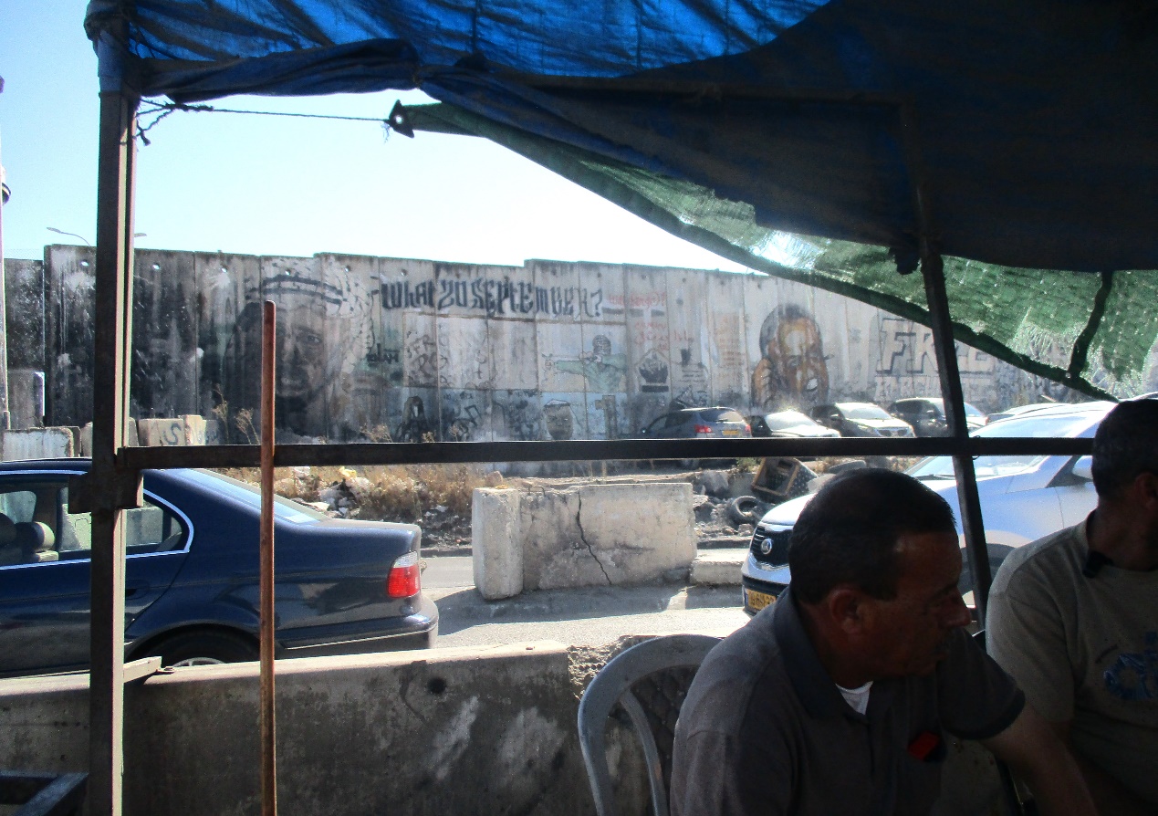
Click here to watch a video from Qalandiya checkpoint up to mid 2019 Three kilometers south of Ramallah, in the heart of Palestinian population. Integrates into "Jerusalem Envelope" as part of Wall that separates between northern suburbs that were annexed to Jerusalem in 1967: Kafr Aqab, Semiramis and Qalandiya, and the villages of Ar-Ram and Bir Nabala, also north of Jerusalem, and the city itself. Some residents of Kafr Aqab, Semiramis and Qalandiya have Jerusalem ID cards. A terminal operated by Israel Police has functioned since early 2006. As of August 2006, northbound pedestrians are not checked. Southbound Palestinians must carry Jerusalem IDs; holders of Palestinian Authority IDs cannot pass without special permits. Vehicular traffic from Ramallah to other West Bank areas runs to the north of Qalandiya. In February 2019, the new facility of the checkpoint was inaugurated aiming to make it like a "border crossing". The bars and barbed wire fences were replaced with walls of perforated metal panels. The check is now performed at multiple stations for face recognition and the transfer of an e-card. The rate of passage has improved and its density has generally decreased, but lack of manpower and malfunctions cause periods of stress. The development and paving of the roads has not yet been completed, the traffic of cars and pedestrians is dangerous, and t the entire vicinity of the checkpoint is filthy. In 2020 a huge pedestrian bridge was built over the vehicle crossing with severe mobility restrictions (steep stairs, long and winding route). The pedestrian access from public transport to the checkpoint from the north (Ramallah direction) is unclear, and there have been cases of people, especially people with disabilities, who accidentally reached the vehicle crossing and were shot by the soldiers at the checkpoint. In the summer of 2021, work began on a new, sunken entrance road from Qalandiya that will lead directly to Road 443 towards Jerusalem and Tel Aviv. At the same time, the runways of the old Atarot airport were demolished and infrastructure was prepared for a large bus terminal. (updated October 2021)
 Tamar FleishmanJul-21-2026Qalandiya. Conversation in the shadow of the wall
-