
‘Anata, Ar-Ram, Atara, Bir Nabala, Jaba (Lil), Qalandiya, Wed 12.3.08, Afternoon
Ar-Ram , Atara
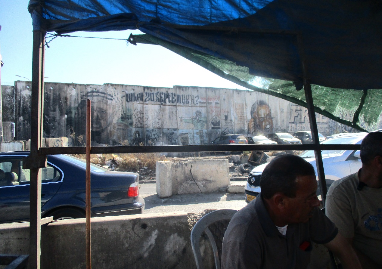
We received extensive explanations regarding A-Ram and the purpose of
the Wall surrounding it from N', a prominent scholar who lives in the area.
On our way to Atara, crossing the Hizme checkpoint northward, we see clearly the Wall
surrounding A-Ram and the network of walls, "security" roads and
empty settler roads that precede the building of a new settlement (an article
on this new settlement was published by Akiva Eldar in Haaretz some days ago). This
new settlement will be built to the northeast of Neve
Yaacov, out of the municipal borders of greater Jerusalem, and will be
connected to the settlement of Adam.
After a short watch in Atara we go back to
A-Ram for an explanatory tour by N', a prominent scholar who lives in the area.
N' tells us that the wall surrounding A-Ram serves the purpose of land
expropriation. The infrastructure
that allows the land expropriation is comprised by roads, settlements, walls
and checkpoints. These four
elements work together towards the same purpose: limiting the movement of
Palestinians, putting large segments of land out of bounds and preventing
Palestinians from caring for the produce of the land, annexing the
"uninhabited" land to settlement tracks and expelling Palestinians
from Jerusalem. N' takes us on a tour from inside A-Ram,
of the wall surrounding the town.
Answering our question regarding the number of inhabitants in A-Ram N'
tells us that 2 or 3 years ago there were nearly 40,000 people living in the
town but since the building of the Wall thousands have moved back to East and
West Jerusalem or the part of Dahiat Al Barid that will remain outside of A-Ram Wall and with
direct access to Jerusalem. Many
streets in A-Ram seem like ghost streets; families have moved to Jerusalem and only come
back home on week-ends, when they don't have to move or travel to work so that
they don't have to cross the checkpoints.
The deserted and empty streets in A-Ram predict a more crowded East Jerusalem.
N' shows us parts of A-Ram that we usually don't visit during our shifts
and explains that in the West Bank villages municipal services are much better
than in these areas close to Jerusalem,
that have been totally impoverished by the Wall, where the infrastructure is
becoming worse and worse.
Jerusalemites who can afford it have moved to East
Jerusalem and those who do not, stay in A-Ram and go through
checkpoints several times a day. N'
believes that when the last section of the Wall is finished, also the week-end
homes will be abandoned.
A-Ram has become totally isolated from Jerusalem, to which it has been connected
from the first half of the past century.
Dahiat Al Barid was
established before 1967 for postal employees from Jerusalem. Neve Yaacov is a pre 1948 settlement that was abandoned and
destroyed in 1948 and became part of Jordan and the land is mostly part
of Hizme, Bet Hanina and
A-Ram. To explain how the Wall
affects the lives of thousands of students and the future of the community, N'
shows us the Palestinian Vocational School, also called the Arab Orphan School
which is the most important vocational school established in the 1950's and
serving A-Ram's, BirNaballah's ,
Ramallah's and other enclaves' youngsters. The school
has remained outside of the A-Ram Wall and thus is out of bounds for Palestinian
youngsters who badly need a vocational education. For Jerusalemites, this is only an
additional vocational school, among others.
The new expansion plan that will unite the land belonging to A-Ram, JabbaDahiat Al-Barid and , at the north-east of Neve Yaacov, with the Adam settlement, exemplifies how the Wall,
supposedly erected to protect Israelis is actually serving to stop all
population expansion of Palestinian towns.
N' says that if the security of Pisgat Zeev
residents were the issue, the Wall would have been built around it. But the purpose, clear today, is land
grabbing.
N says that the issue of giving Palestinians a footing in Jerusalem – a basic demand for the 2 state solution – could be solved by connecting A-Ram from the east
to Hizme and Anata and this
would provide an eastern open gate for Palestinian expansion and a passage to Jerusalem. However, the Wall effectively stops this
and in fact makes each small town an unsustainable, closed unit, disconnected
from Jerusalem.
E-1 plan is another example of this closure of East
Jerusalem to Palestinians, as is road No. 1: all land east of Road
No. 1, from Damascus Gate to Neve Yaacov,
was confiscated when the road was built.
We ask N' to corroborate the information we gave on our reports of 6.2.08
and 10.2.08 that the pressure from the Vatican
made the IDF remove the barbed wire and the planned barrier near the Rosary School
in Dahiat Al Barid. He tells us that, in fact, it was the
threat of going to the Supreme Court that made the IDF remove
the barbed wire around a few buildings and the Rosary School
at the southern-most end of A-Ram. So
we correct: The neighbors got organized and employed a lawyer and it was that,
and not the pressure from the Vatican,
that got the barbed wire removed.
'Atara
See all reports for this place-
'Atara Checkpoint
Situated at the northern entrance to Ramallah from Route 465, called also Bir Zeit Checkpoint. Nowadays only remains of what used to be a busy checkpoint remain, a pillbox and concrete blocks.
-
A-Ram
See all reports for this place-
two kilometers south of Qalandiya and 300 metres north of Neve Yaacov Junction, in Dahiyat el-Barid Quarter. Checkpoint has operated since 1991, in a Palestinian area annexed to Jerusalem in 1967. The checkpoint has been inactive since the middle of 2009.
The wall was built on the road that led to Jerusalem. Since then the situation in the town has deteriorated. Houses are abandoned and half finished, most of the businesses have closed. Severe neglect around the fence and on the streets. Those who could left. Updated January 2024
-
Checkpoint Shu'afat camp / Anata-Shu'afat (Jerusalem)
See all reports for this place-
The Shu’afat checkpoint is located in the northern part of East Jerusalem at the exit from the village of Anata and the Shu’afat refugee camp, which are located in the area annexed to Jerusalem in 1967. The refugee camp borders the Shu’afat neighborhood to the west, Pisgat Ze’ev to the north, the French Hill neighborhood to the south and the planned expansion of Ma’aleh Adumim to E-1 in the east. It was established in 1966 for 1948 refugees from the West Bank and was populated after the Six Day War by persons who had been expelled from the Jewish Quarter. Today its population comprises some 25,000 people holding blue ID cards and some 15,000 people with Palestinian ID cards. The camp lacks adequate infrastructure and services, and suffers from poverty, neglect and overcrowding. All its buildings are connected to the public electricity and water infrastructure, but not all are connected to the sewer system. The camp’s services are provided by UNRWA, except for those such as health clinics and transportation of pupils to schools in Jerusalem. In 2005, the Israeli High Court of Justice rejected a suit by the residents requesting that the route of the separation fence be drawn such that the camp would remain on the Israeli side, but conditioned its approval of the route on the establishment of a convenient and rapid crossing facility for the inhabitants of the neighborhood, most of whom are residents of Jerusalem.
A temporary checkpoint operated there until December, 2011. It was extremely congested during rush hours, and dangerous for pedestrians (especially children) because of inadequate safety provisions. The new checkpoint was inaugurated south of the old one, for public and private transportation and for pedestrians, intended solely for the residents of the camp – holders of blue ID cards, and those with Palestinian ID cards who possess appropriate permits. There are five vehicle inspection stations at the checkpoint, and two for pedestrians (one of which is currently closed) where scanners have been installed but are not yet operating. According to the army, representatives of government agencies will also be present to provide services to residents of the neighbourhood. The pedestrian lanes are very long, located far from the small parking lots, and accessible through only a single revolving gate. Anat TuegJan-25-2026Anata: A new outpost has been built south of the junction
-
Jaba' (Lil)
See all reports for this place-
Jaba' (Lil) In fact, the Jaba checkpoint is east of the Qalandiya checkpoint. Its declared purpose is the prevention of Israeli citizens from entering Area A. A road checkpoint for vehicles, located on Road 65, borders the southern fence of Kfar Jaba, about three kilometers east of the Qalandiya checkpoint, on the road leading to the settlement of Adam on Road 60. Archaeological excavations within the village found the remains of a cloth house from the First Temple period. The events that led to the construction of the checkpoint are precisely here: on the day of the abduction of Gilad Shalit and before the outbreak of the Second Lebanon War, a 17-year-old man from one of the settlements was abducted by a Palestinian cell. His body was found several days later at the entrances to Ramallah. A military investigation revealed that his abductors had taken him along this route. The checkpoint was set up to prevent future kidnappings and to warn settlers from traveling to Ramallah and entering Area A (which is forbidden for Israelis). The checkpoint that operates around the clock. Usually only vehicles traveling in the direction of Ramallah are inspected. (November 2016): Every morning, when the settlers en masse travel to Jerusalem on Route 60 and every afternoon they return from Jerusalem on Route 60, the army initiates a traffic jam at the entrance to the Jaba checkpoint and stops the movement of Palestinians traveling toward Route 60. (February 2020): In the last two years the checkpoint has not always been manned. Sometimes the soldiers come and just stand, sometimes they come and stop and check those who enter the village, sometimes they patrol the alleys of the village, sometimes they fire stun grenades and gas and sometimes they invade houses and stop young people, say those passing through the Hazma checkpoint. (Updated February 2020)
-
Qalandiya Checkpoint / Atarot Pass (Jerusalem)
See all reports for this place-
Click here to watch a video from Qalandiya checkpoint up to mid 2019 Three kilometers south of Ramallah, in the heart of Palestinian population. Integrates into "Jerusalem Envelope" as part of Wall that separates between northern suburbs that were annexed to Jerusalem in 1967: Kafr Aqab, Semiramis and Qalandiya, and the villages of Ar-Ram and Bir Nabala, also north of Jerusalem, and the city itself. Some residents of Kafr Aqab, Semiramis and Qalandiya have Jerusalem ID cards. A terminal operated by Israel Police has functioned since early 2006. As of August 2006, northbound pedestrians are not checked. Southbound Palestinians must carry Jerusalem IDs; holders of Palestinian Authority IDs cannot pass without special permits. Vehicular traffic from Ramallah to other West Bank areas runs to the north of Qalandiya. In February 2019, the new facility of the checkpoint was inaugurated aiming to make it like a "border crossing". The bars and barbed wire fences were replaced with walls of perforated metal panels. The check is now performed at multiple stations for face recognition and the transfer of an e-card. The rate of passage has improved and its density has generally decreased, but lack of manpower and malfunctions cause periods of stress. The development and paving of the roads has not yet been completed, the traffic of cars and pedestrians is dangerous, and t the entire vicinity of the checkpoint is filthy. In 2020 a huge pedestrian bridge was built over the vehicle crossing with severe mobility restrictions (steep stairs, long and winding route). The pedestrian access from public transport to the checkpoint from the north (Ramallah direction) is unclear, and there have been cases of people, especially people with disabilities, who accidentally reached the vehicle crossing and were shot by the soldiers at the checkpoint. In the summer of 2021, work began on a new, sunken entrance road from Qalandiya that will lead directly to Road 443 towards Jerusalem and Tel Aviv. At the same time, the runways of the old Atarot airport were demolished and infrastructure was prepared for a large bus terminal. (updated October 2021)
 Tamar FleishmanJul-21-2026Qalandiya. Conversation in the shadow of the wall
-
Rafat (Bir Nabala)
See all reports for this place-
Rafat (Bir Nabala) With the completion of the Bir Nabala enclave, which includes also Al Jib, Al Judeira and Beit Hanina al Balad, a checkpoint was put at enclave exit. The passage into the enclave is allowed only to the enclave inhabitants and to Ramallah District people.
-
