
‘Anata, Ar-Ram, Hizma, Jaba (Lil), Qalandiya, יום ה’ 19.3.09, אחה”צ
From 2:30 till 6:00 PM
Givat Zeev CP, Vocational School Atarot, Qalandia, Leel, road via Hizme to
Jericho Road, Anata, A-Ram, Nebi Samuel and Ramot CP.
Our shift this time involved a lot of driving. The wall along the road from
Ramot to Givat Zeev is now almost completed and it is hard to discern where
the lower road under the highway, meant only for Palestinians is actually
located. The G. Zeev CP has been built up and looks as if it will turn into
one of the major passages into the W. Bank. At this time we could drive all
the way to where huge boulders blocked our way to the cars and cabs waiting
for workers to return home. Two or three actually already proceeded on foot
via a dirt track to a small shed where a soldier was checking their
documents.
In search of our friend the Principal of the Vocational High school in
Atarot, we heard that schools are closed on Thursdays and Fridays – the
students who live far off (Jenin, Nablus and Hebron) go home on
Wednesday-afternoon to return to classes on Saturday morning. We will try
and find Mr. Wasfi Tamimi on another day. We took the guard of the school
who had finished his shift, to the Qalandia CP and crossed North with the
car without any delay, then continued along heaps of garbage and also
beautifully exhibited vegetable stands via Leel (again no control
whatsoever) and decided to take the road all the way down to the Mishor
Adumim Industrial Area. On the way we saw new road construction and parked
cars at the Eastern entrance to Anata and then encountered the signs of the
soon to be constructed Nofei Anatot settlement. Further down the road we
noticed how the Bedouin are being pushed aside by enormous quarries. On the
right we got a good view of the Police HQs on Area E1 and then saw the first
signs telling us that ‘Mevasseret Adumin is HERE!' We then went into Anata
from the West and saw that more vegetable stands have been erected and
another elongated ‘cage' has been set up on the northern side of the road,
facilitating the work of the soldiers checking those who exit to Jerusalem.
The BP-girl didn't check our Id's when she realized we were Watch Women.
We then continued to A-Ram and saw that the wall indeed now closed off the
entire neighborhood, facilitating the access for us to Qalandia. The ‘random'
Atarot CP, which has been almost empty when we passed from the other side,
now had to deal with a long line of waiting cars, but we left unhindered to
the other direction. In Nebi Samuel there were lots of cars and buses at the
Jewish site. In the village we noted farm animals (sheep, donkeys and
chickens) in a couple of improvised pens and wondered whether the Red Cross
had provided them. Our acquaintance of the grocery store was very upset. He
had bought loads of vegetables wanting to make some kind of a living and had
set up a stand (on his own land) near the Jewish Pilgrimage site, hoping to
do a brisk business. An orthodox Jewish ‘friend' (his ‘brother') a dropout
from the Yeshiva on that spot confirmed the story. He had been given three
days to dismantle everything and when he was not fast enough, the ‘minhal' –
people who demolish houses sent by the Civil Administration – had come and
trampled over everything causing him to lose a lot of money because he had
invested in vegetables the local population doesn't eat, such as beets,
sweet potatoes, etc. He can now throw it all away. He has contacted B'Tselem
and his lawyer and begged us to report on the matter, which we promised to
do.
At the Ramot CP we saw a police car stopping cars at random and also two
cars parked on the side of the road, when we went to investigate it turned
out that one of the cars had punctured tires because it had driven over the
police barrier and waited for assistance and that the police was after
stolen cars; the Border Police soldier who assisted them answered us: "Don't
worry this is not a CP in the territories," implying that here all they do
is OK unlike on the other side of the wall.
A-Ram
See all reports for this place-
two kilometers south of Qalandiya and 300 metres north of Neve Yaacov Junction, in Dahiyat el-Barid Quarter. Checkpoint has operated since 1991, in a Palestinian area annexed to Jerusalem in 1967. The checkpoint has been inactive since the middle of 2009.
The wall was built on the road that led to Jerusalem. Since then the situation in the town has deteriorated. Houses are abandoned and half finished, most of the businesses have closed. Severe neglect around the fence and on the streets. Those who could left. Updated January 2024
-
Checkpoint Shu'afat camp / Anata-Shu'afat (Jerusalem)
See all reports for this place-
The Shu’afat checkpoint is located in the northern part of East Jerusalem at the exit from the village of Anata and the Shu’afat refugee camp, which are located in the area annexed to Jerusalem in 1967. The refugee camp borders the Shu’afat neighborhood to the west, Pisgat Ze’ev to the north, the French Hill neighborhood to the south and the planned expansion of Ma’aleh Adumim to E-1 in the east. It was established in 1966 for 1948 refugees from the West Bank and was populated after the Six Day War by persons who had been expelled from the Jewish Quarter. Today its population comprises some 25,000 people holding blue ID cards and some 15,000 people with Palestinian ID cards. The camp lacks adequate infrastructure and services, and suffers from poverty, neglect and overcrowding. All its buildings are connected to the public electricity and water infrastructure, but not all are connected to the sewer system. The camp’s services are provided by UNRWA, except for those such as health clinics and transportation of pupils to schools in Jerusalem. In 2005, the Israeli High Court of Justice rejected a suit by the residents requesting that the route of the separation fence be drawn such that the camp would remain on the Israeli side, but conditioned its approval of the route on the establishment of a convenient and rapid crossing facility for the inhabitants of the neighborhood, most of whom are residents of Jerusalem.
A temporary checkpoint operated there until December, 2011. It was extremely congested during rush hours, and dangerous for pedestrians (especially children) because of inadequate safety provisions. The new checkpoint was inaugurated south of the old one, for public and private transportation and for pedestrians, intended solely for the residents of the camp – holders of blue ID cards, and those with Palestinian ID cards who possess appropriate permits. There are five vehicle inspection stations at the checkpoint, and two for pedestrians (one of which is currently closed) where scanners have been installed but are not yet operating. According to the army, representatives of government agencies will also be present to provide services to residents of the neighbourhood. The pedestrian lanes are very long, located far from the small parking lots, and accessible through only a single revolving gate. Anat TuegJan-25-2026Anata: A new outpost has been built south of the junction
-
Hizma
See all reports for this place-
Hizma
A checkpoint at the north-eastern entrance to the Jerusalem area which was annexed in 1967, at Pisgat Zeev. The passage is allowed to bearers of blue IDs only. Open 24 hours a day.
-
Jaba' (Lil)
See all reports for this place-
Jaba' (Lil) In fact, the Jaba checkpoint is east of the Qalandiya checkpoint. Its declared purpose is the prevention of Israeli citizens from entering Area A. A road checkpoint for vehicles, located on Road 65, borders the southern fence of Kfar Jaba, about three kilometers east of the Qalandiya checkpoint, on the road leading to the settlement of Adam on Road 60. Archaeological excavations within the village found the remains of a cloth house from the First Temple period. The events that led to the construction of the checkpoint are precisely here: on the day of the abduction of Gilad Shalit and before the outbreak of the Second Lebanon War, a 17-year-old man from one of the settlements was abducted by a Palestinian cell. His body was found several days later at the entrances to Ramallah. A military investigation revealed that his abductors had taken him along this route. The checkpoint was set up to prevent future kidnappings and to warn settlers from traveling to Ramallah and entering Area A (which is forbidden for Israelis). The checkpoint that operates around the clock. Usually only vehicles traveling in the direction of Ramallah are inspected. (November 2016): Every morning, when the settlers en masse travel to Jerusalem on Route 60 and every afternoon they return from Jerusalem on Route 60, the army initiates a traffic jam at the entrance to the Jaba checkpoint and stops the movement of Palestinians traveling toward Route 60. (February 2020): In the last two years the checkpoint has not always been manned. Sometimes the soldiers come and just stand, sometimes they come and stop and check those who enter the village, sometimes they patrol the alleys of the village, sometimes they fire stun grenades and gas and sometimes they invade houses and stop young people, say those passing through the Hazma checkpoint. (Updated February 2020)
-
Qalandiya Checkpoint / Atarot Pass (Jerusalem)
See all reports for this place-
Click here to watch a video from Qalandiya checkpoint up to mid 2019 Three kilometers south of Ramallah, in the heart of Palestinian population. Integrates into "Jerusalem Envelope" as part of Wall that separates between northern suburbs that were annexed to Jerusalem in 1967: Kafr Aqab, Semiramis and Qalandiya, and the villages of Ar-Ram and Bir Nabala, also north of Jerusalem, and the city itself. Some residents of Kafr Aqab, Semiramis and Qalandiya have Jerusalem ID cards. A terminal operated by Israel Police has functioned since early 2006. As of August 2006, northbound pedestrians are not checked. Southbound Palestinians must carry Jerusalem IDs; holders of Palestinian Authority IDs cannot pass without special permits. Vehicular traffic from Ramallah to other West Bank areas runs to the north of Qalandiya. In February 2019, the new facility of the checkpoint was inaugurated aiming to make it like a "border crossing". The bars and barbed wire fences were replaced with walls of perforated metal panels. The check is now performed at multiple stations for face recognition and the transfer of an e-card. The rate of passage has improved and its density has generally decreased, but lack of manpower and malfunctions cause periods of stress. The development and paving of the roads has not yet been completed, the traffic of cars and pedestrians is dangerous, and t the entire vicinity of the checkpoint is filthy. In 2020 a huge pedestrian bridge was built over the vehicle crossing with severe mobility restrictions (steep stairs, long and winding route). The pedestrian access from public transport to the checkpoint from the north (Ramallah direction) is unclear, and there have been cases of people, especially people with disabilities, who accidentally reached the vehicle crossing and were shot by the soldiers at the checkpoint. In the summer of 2021, work began on a new, sunken entrance road from Qalandiya that will lead directly to Road 443 towards Jerusalem and Tel Aviv. At the same time, the runways of the old Atarot airport were demolished and infrastructure was prepared for a large bus terminal. (updated October 2021)
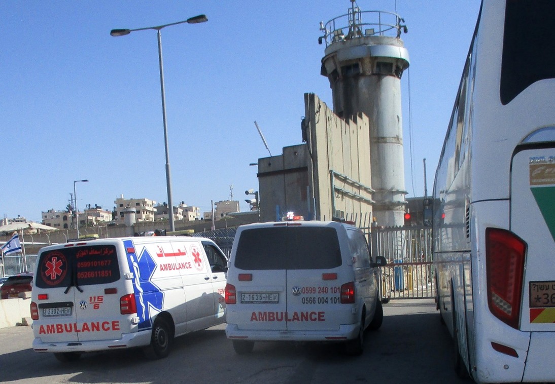 Tamar FleishmanMay-11-2026Qalandiya. Ambulances wait in front of a closed checkpoint
-