
‘Anata, Hizma, Qalandiya, Thu 18.3.10, Morning
At 6:30am, Qalandiya lines were moving quickly and orderly. The Ecumencial Observers praised the commander and his unit, suggesting that when this commander and his unit were on duty, the system seemed to be more efficient. We thanked the commander. We might also note that perhaps the installation of surveillance cameras helped to ease the passage and that through the years, the Druze soldiers on duty at Qalandia seemed to handle the situations there well. We left at 7:30,
determining that Qalandiya was running smoothly
Arriving at Anata, through the Hizma checkpoint, it was bumper to bumper traffic.
Anata was tense with more soldiers than usual checking cars more thoroughly. One soldier told us that it had been a difficult night and that he had been pelted with rocks. Another soldier asked us to move from the entrance and though we did explain to him that we had a right to be there, we complied as we felt his sense of panic and concern. In the school bus area things appeared to be going smoothly.
Checkpoint Shu'afat camp / Anata-Shu'afat (Jerusalem)
See all reports for this place-
The Shu’afat checkpoint is located in the northern part of East Jerusalem at the exit from the village of Anata and the Shu’afat refugee camp, which are located in the area annexed to Jerusalem in 1967. The refugee camp borders the Shu’afat neighborhood to the west, Pisgat Ze’ev to the north, the French Hill neighborhood to the south and the planned expansion of Ma’aleh Adumim to E-1 in the east. It was established in 1966 for 1948 refugees from the West Bank and was populated after the Six Day War by persons who had been expelled from the Jewish Quarter. Today its population comprises some 25,000 people holding blue ID cards and some 15,000 people with Palestinian ID cards. The camp lacks adequate infrastructure and services, and suffers from poverty, neglect and overcrowding. All its buildings are connected to the public electricity and water infrastructure, but not all are connected to the sewer system. The camp’s services are provided by UNRWA, except for those such as health clinics and transportation of pupils to schools in Jerusalem. In 2005, the Israeli High Court of Justice rejected a suit by the residents requesting that the route of the separation fence be drawn such that the camp would remain on the Israeli side, but conditioned its approval of the route on the establishment of a convenient and rapid crossing facility for the inhabitants of the neighborhood, most of whom are residents of Jerusalem.
A temporary checkpoint operated there until December, 2011. It was extremely congested during rush hours, and dangerous for pedestrians (especially children) because of inadequate safety provisions. The new checkpoint was inaugurated south of the old one, for public and private transportation and for pedestrians, intended solely for the residents of the camp – holders of blue ID cards, and those with Palestinian ID cards who possess appropriate permits. There are five vehicle inspection stations at the checkpoint, and two for pedestrians (one of which is currently closed) where scanners have been installed but are not yet operating. According to the army, representatives of government agencies will also be present to provide services to residents of the neighbourhood. The pedestrian lanes are very long, located far from the small parking lots, and accessible through only a single revolving gate. Anat TuegJan-25-2026Anata: A new outpost has been built south of the junction
-
Hizma
See all reports for this place-
Hizma
A checkpoint at the north-eastern entrance to the Jerusalem area which was annexed in 1967, at Pisgat Zeev. The passage is allowed to bearers of blue IDs only. Open 24 hours a day.
-
Qalandiya Checkpoint / Atarot Pass (Jerusalem)
See all reports for this place-
Click here to watch a video from Qalandiya checkpoint up to mid 2019 Three kilometers south of Ramallah, in the heart of Palestinian population. Integrates into "Jerusalem Envelope" as part of Wall that separates between northern suburbs that were annexed to Jerusalem in 1967: Kafr Aqab, Semiramis and Qalandiya, and the villages of Ar-Ram and Bir Nabala, also north of Jerusalem, and the city itself. Some residents of Kafr Aqab, Semiramis and Qalandiya have Jerusalem ID cards. A terminal operated by Israel Police has functioned since early 2006. As of August 2006, northbound pedestrians are not checked. Southbound Palestinians must carry Jerusalem IDs; holders of Palestinian Authority IDs cannot pass without special permits. Vehicular traffic from Ramallah to other West Bank areas runs to the north of Qalandiya. In February 2019, the new facility of the checkpoint was inaugurated aiming to make it like a "border crossing". The bars and barbed wire fences were replaced with walls of perforated metal panels. The check is now performed at multiple stations for face recognition and the transfer of an e-card. The rate of passage has improved and its density has generally decreased, but lack of manpower and malfunctions cause periods of stress. The development and paving of the roads has not yet been completed, the traffic of cars and pedestrians is dangerous, and t the entire vicinity of the checkpoint is filthy. In 2020 a huge pedestrian bridge was built over the vehicle crossing with severe mobility restrictions (steep stairs, long and winding route). The pedestrian access from public transport to the checkpoint from the north (Ramallah direction) is unclear, and there have been cases of people, especially people with disabilities, who accidentally reached the vehicle crossing and were shot by the soldiers at the checkpoint. In the summer of 2021, work began on a new, sunken entrance road from Qalandiya that will lead directly to Road 443 towards Jerusalem and Tel Aviv. At the same time, the runways of the old Atarot airport were demolished and infrastructure was prepared for a large bus terminal. (updated October 2021)
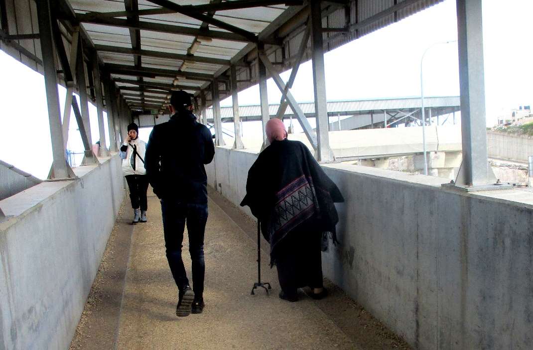 Tamar FleishmanJun-28-2026Qalandiya. The bridge leading from Jerusalem to the Qalandiya checkpoint
-