
‘Anata-Shu’afat, Abu Dis, Container (Wadi Nar), Ras Abu Sbitan (Olive Terminal), Wed 22.5.13, Morning
The construction of the wall is progressing, and traffic arrangements in E1 and Wadi Nar area are about to change, but not clear when.
Shuafat refugee camp
We met G. from the neighbourhood committee in the parking lot for children's transportation, and asked him to organize a tour for us together with Ir Amim and the Civil Rights Organization, and perhaps a representative of the Municipality — this in the wake of our meeting a month ago in the boys' school with some of the neighbourhood residents and Meir Margalit from the Jerusalem City Council. There was a discussion of specific problems related to the bad state of the neighbourhood now enclosed behind the wall. Ir Amim and the Civil Rights 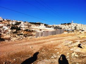 Organization will soon publish special reports on the condition of the excluded area, with the hope of improving matters with combined efforts.
The Municipality representative dealt with the restoration of computers to the school, after they were stolen some four months ago. Despite insurance which should have replaced them within a few days, the school has remained without computers since the theft.
The parking lot is lively with well-dressed pupils (not in flip-flops like ours…). Compared to previous weeks, the atmosphere is calm. Few are crossing in the pedestrian crossing, and the soldiers come out of their glass boxes to check documents manually. At the crossing for vehicles we were told that Red Crescent ambulances cross at the rate of two a day, mostly without delays on entrance to the camp. On leaving, they are checked.
Olive Terminal — from the outside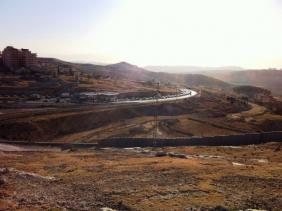
The construction of the wall advances, from the area of the lower Az-Za'ayyem checkpoint up the hill towards Olive Terminal (see photos). Traffic coming from Ma'aleh Adumim becomes heavily congested at the Az-Za'ayyem checkpoint. This is the route from Al Ezariya to Wadi Nar checkpoint.
On our way we meet a delegation of Palestinian construction workers, working — they tell us — with AID USA funding, on widening the road to Wadi Nar and from there to Al Ezariya. According to them, work will start next week and traffic will be diverted through Sawaharrah A-Sharkiya. The steep and winding road to Wadi Nar will be slightly broader with concrete safety barriers; the other direction will be broadened to two lanes. We shall return to inspect next week.
Wadi Nar
Fewer dogs this time, without barking and attacks on passers-by.
Abu Dis / Lazarus gate (formerly The Wicket)
See all reports for this place-
Abu Dis / Lazarus Checkpoint/Gate (east of the former “wicket”)
Construction of the wall in the Abu Dis area blocked all the gaps that allowed people to cross from al-Ezariya to the neighbourhoods of Abu Dis and Ras al 'Amud that are located within Jerusalem’s municipal boundary. The Lazarus checkpoint is a gate in the wall adjacent to the Lazarus Monastery. Until 2011 it had a door for pilgrims to al-Ezariya and for the monastery’s kindergarten pupils from al-Ezariya. The crossing is currently closed, but the site has infrastructure for conducting inspections.
-
Checkpoint Shu'afat camp / Anata-Shu'afat (Jerusalem)
See all reports for this place-
The Shu’afat checkpoint is located in the northern part of East Jerusalem at the exit from the village of Anata and the Shu’afat refugee camp, which are located in the area annexed to Jerusalem in 1967. The refugee camp borders the Shu’afat neighborhood to the west, Pisgat Ze’ev to the north, the French Hill neighborhood to the south and the planned expansion of Ma’aleh Adumim to E-1 in the east. It was established in 1966 for 1948 refugees from the West Bank and was populated after the Six Day War by persons who had been expelled from the Jewish Quarter. Today its population comprises some 25,000 people holding blue ID cards and some 15,000 people with Palestinian ID cards. The camp lacks adequate infrastructure and services, and suffers from poverty, neglect and overcrowding. All its buildings are connected to the public electricity and water infrastructure, but not all are connected to the sewer system. The camp’s services are provided by UNRWA, except for those such as health clinics and transportation of pupils to schools in Jerusalem. In 2005, the Israeli High Court of Justice rejected a suit by the residents requesting that the route of the separation fence be drawn such that the camp would remain on the Israeli side, but conditioned its approval of the route on the establishment of a convenient and rapid crossing facility for the inhabitants of the neighborhood, most of whom are residents of Jerusalem.
A temporary checkpoint operated there until December, 2011. It was extremely congested during rush hours, and dangerous for pedestrians (especially children) because of inadequate safety provisions. The new checkpoint was inaugurated south of the old one, for public and private transportation and for pedestrians, intended solely for the residents of the camp – holders of blue ID cards, and those with Palestinian ID cards who possess appropriate permits. There are five vehicle inspection stations at the checkpoint, and two for pedestrians (one of which is currently closed) where scanners have been installed but are not yet operating. According to the army, representatives of government agencies will also be present to provide services to residents of the neighbourhood. The pedestrian lanes are very long, located far from the small parking lots, and accessible through only a single revolving gate. Anat TuegJan-25-2026Anata: A new outpost has been built south of the junction
-
Container (Wadi Nar)
See all reports for this place-
Wadi Nar Checkpoint ("Container", "The Kiosk") - a barrier for vehicles in Area B that is regularly manned - east of Abu Dis between Sawahra A Sharqiya and Bethlehem and its daughters. Controls Palestinian movement between the north and south West-Bank. Includes driving routes, access roads, spikes, traffic lights and signs. There is no pedestrian crossing. Open 24 hours a day with random checks enhanced on security alerts. The checkpoint is in Palestinian territory, allowing for separation between the north and the south Palestinian areas when necessary.
In 2015, the leading road from Azaria to Bethlehem was renovated, as well as the steep and narrow ascent to the Wadi Nar checkpoint, which was dangerously travelled in both directions! The temporary checkpoint was renovated and expanded, and pedestrian traffic was banned. From 2016, traffic travelling from the south bank to Azaria was directed to a one-way road near the Southern Keydar Jewish settlement.
Machsomwatch shifts visit this far-fetched checkpoint only occasionally.
(updated to July 2019)
-
Ras Abu Sbitan (Olive Terminal)
See all reports for this place-
A large checkpoint/crossing to the area of a-Tur, Abu Dis and the Old City; only for pedestrians. Located on Jerusalem’s municipal boundary.
One of the major crossings in Jerusalem’s central sector. It is located on the separation fence between the northern portion of the al-Ezariya neighborhood and the neighborhood of a-Tur and the rest of East Jerusalem. It is manned by Border Police soldiers and private security companies and operates 24 hours a day. Palestinians are forbidden to go through, other than permanent residents of East Jerusalem (holders of blue ID cards) and holders of work and commercial permits who are allowed through only on foot.
-