
‘Awarta, Beit Furik, Huwwara, Za’tara (Tapuah)
After four months, we returned as a couple to our old route. The Ramadan fasting was over, the holiday had ended and there was no tension on the roads.
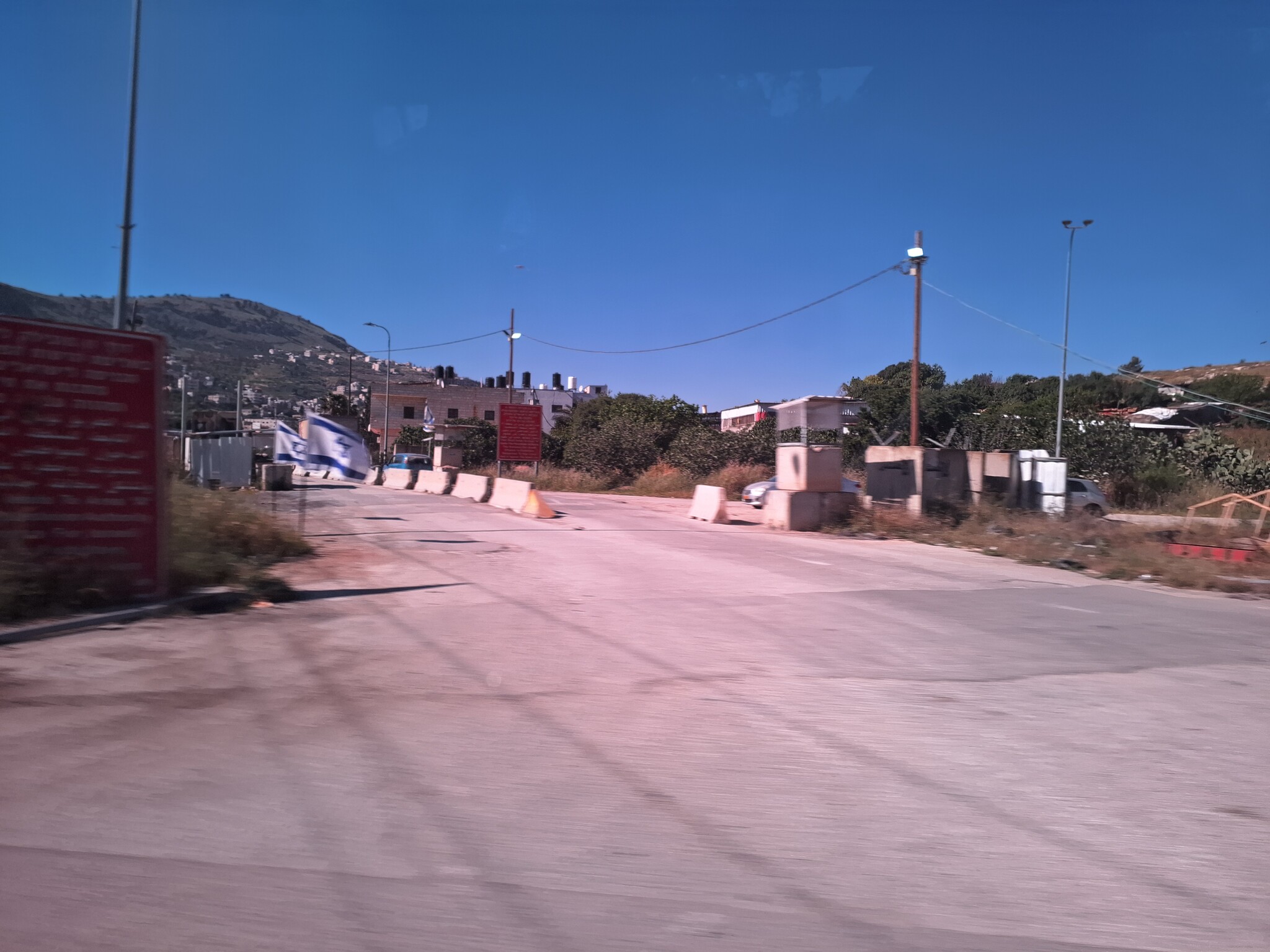
08:00 Oranit: We didn’t manage to reach the agricultural gate: Beit Amin 1448//1447. The net gate blocking the passage from the square in Oranit to the security road was locked. Of course, there were no contractors waiting at the junction. (See picture)By the way, the big sign saying Hayim Landau Road was not there any longer.

Shomron Gate: The traffic was flowing.
08: 20 Za’atra/Tapuah: The checkpoint was unmanned and the traffic was flowing. Some soldiers were posted at the settlers’ hitchhike stop which was “decorated” with signs calling for a “fight against terrorism”. A wide path paved with Ackerstein tiles leads up to the stop. There seems to be a lot of money for the development of the Shomron.
A big road beginning at the square opposite Beita and ending at the square opposite the exit towards Yitzhar/Burin leads through Hawara. The plantations on the dividing line hadn’t yet begun but garbage was being collected along the road. Eventually, there might even be a sidewalk.
Yitzhar/Burin: There were no army vehicles in the bay west of the highway.
At the Huwwara checkpoint soldiers were going up to the pool near the stop for hitchhikers. At the turn to the regiment two shielded soldiers stopped a Palestinian vehicle. One soldier explained us that Palestinians are not allowed to drive on Madison Route. The other silenced him telling him not to talk to us.
Awarta: We were sorry to find the yellow barrier locked again. There was no army presence on Madison Route or opposite Itamar even though hitchhikers were waiting at the stop.
09:05 Beit Furik: The checkpoint tower was unmanned and there were no soldiers on the road. The development of the village was progressing and new roads were being paved.
09:15 Huwwara checkpoint:The checkpoint was unmanned. Again, a Palestinian car was detained on Madison Route. In the direction of Burin, a settler was trying to catch a lift. A shielded soldier was keeping watch.
“One soldier for every settler”
Yitzhar/Burin: No army presence.
In Huwwara, the traffic was flowing. Unlike former visits, this time we didn’t see any army vehicles in ambush along the main road.
09:30 Za’atra/Tapuah: An Israeli police car was parking nearby but the check posts were unmanned and the traffic was flowing.
Shomron Gate: The traffic was flowing.
'Awarta
See all reports for this place-
Awarta, an internal checkpoint in the heart of the West Bank, is located east of the Hawara checkpoint, at the junction of Roads 555 (which was forbidden for Palestinian traffic in this area) and the entrance road to Nablus. It was one of the four checkpoints that surrounded Nablus until 2009. We used to watch it at Huwwara shifts because it was the only one where goods could be transferred to and from Nablus, using the back-to-back method. It was operated by the army, from 06:00 to 20:00. Until 2009.
 Ronit Dahan-RamatiApr-23-2026Awarta Checkpoint is empty
-
Beit Furik checkpoint
See all reports for this place-
One of the three internal checkpoints that closed on the city of Nablus - Beit Furik to the east, Hawara to the south, Beit Iba to the west. The checkpoint is located at the junction of Roads 557 (an apartheid road that was forbidden for Palestinians), leading to the Itamar and Alon Morea settlements and Road 5487. The checkpoint was established in 2001 for pedestrians and vehicles; The opening hours were short and the transition was slow and very problematic.Allegedly, the checkpoint is intended to monitor the movement to and from Nablus of the residents of Beit Furik and Beit Dajan, being the only opening outside their villages. Since May 2009 the checkpoint is open 24 hours a day, the military presence is limited, vehicles can pass through it without inspections, except for random inspections. (Updated April 2010)
-
Huwwara
See all reports for this place-
The Huwwara checkpoint is an internal checkpoint south of the city of Nablus, at the intersection of Roads 60 and 5077 (between the settlements of Bracha and Itamar). This checkpoint was one of the four permanent checkpoints that closed on Nablus (Beit Furik and Awarta checkpoints to the east and the Beit Iba checkpoint to the west). It was a pedestrian-only barrier. As MachsomWatch volunteers, we watched therre since 2001 two shifts a day - morning and noon, the thousands of Palestinians leaving Nablus and waiting for hours in queues to reach anywhere else in the West Bank, from the other side of the checkpoint the destination could only be reached by public transport. In early June 2009, as part of the easing of Palestinian traffic in the West Bank, the checkpoint was opened to vehicular traffic. The passage was free, with occasional military presence in the guard tower. Also, there were vehicle inspections from time to time. Since the massacre on 7.10.2023, the checkpoint has been closed to Palestinians.
On February 26, 2023, about 400 settlers attacked the town's residents for 5 hours and set fire to property, such as houses and cars. Disturbances occurred in response to a shooting of two Jewish residents of Har Bracha by a Palestinian Terrorist. The soldiers stationed in the town did not prevent the arson and rescued Palestinian families from their homes only after they were set on fire. No one was punished and Finance Minister Smotrich stated that "the State of Israel should wipe out Hawara." Left and center organizations organized solidarity demonstrations and support actions for the residents of Hawara.Hawara continued to be in the headlines in all the months that followed: more pogroms by the settlers, attacks by Palestinians and a massive presence of the army in the town. It amounted to a de facto curfew of commerce and life in the center of the city. On October 5, 2023, MK Zvi established a Sukkah in the center of Hawara and hundreds of settlers backed the army blocked the main road and held prayers in the heart of the town all night and the next day. On Saturday, October 7, 23 The "Swords of Iron" war began with an attack by Hamas on settlements surrounding Gaza in the face of a poor presence of the IDF. Much criticism has been made of the withdrawal of military forces from the area surrounding Gaza and their placement in the West Bank, and in the Hawara and Samaria region in particular, as a shield for the settlers who were taking over and rioting.
On November 12, 2023, the first section of the Hawara bypass road intended for Israeli traffic only was opened. In this way, the settlers can bypass the road that goes through the center of Hawara, which is the main artery for traffic from the Nablus area to Ramallah and the south of the West Bank. For the construction of the road, the Civil Administration expropriated 406 dunams of private land belonging to Palestinians from the nearby villages. The settlers are not satisfied with this at the moment, and demand to also travel through Hawara itself in order to demonstrate presence and control.(updated November 2023)
. Shoshi AnbarMay-18-2025Huwara: The old houses in Area C
-
Za'tara (Tapuah)
See all reports for this place-
Za'tara (Tapuah) Za'tara is an internal checkpoint in the heart of the West Bank, at the intersection of Road 60 and Road 505 (Trans-Samaria), east of the Tapuah settlement. This checkpoint is the "border" marked by the IDF between the north and south of the West Bank, in accordance with the policy of separation between the two parts of the West Bank that has been in place since December 2005. At the Za'tara checkpoint, there are separate routes for Israelis and Palestinians. In the route for Israelis, there are no inspections and the route for Palestinians inspects. The queue lengthens and shortens suits. The checkpoint is open 24 hours a day. The checkpoint is partially staffed and the people who pass through it are checked at random.
 Shoshi AnbarSep-27-2023Za'atra (Tapuah Intersection). Signs
-