
‘Azzun ‘Atma, Beit Furik, Habla, Za’tara (Tapuah), Thu 21.3.13, Afternoon
Translator: Charles K.
While Barack Obama, the President of the United States, is in Israel giving a speech about peace – a notice posted on the fence of the Huwwara checkpoint announces the establishment of new settlements in Palestinian territory.
Note: While conditions have been eased at the checkpoints in comparison to what we’ve seen in the past, the occupier’s presence has been expanded, as will be seen from this report.
14:00 Habla checkpoint
We arrived as the gate closed. It will reopen only in the evening for laborers returning from work.
14:07 Eliyahu crossing
The driver of a car with Israeli license plates is having his documents checked as he leaves Israel.
14:13 An army jeep is parked before the Ma’aleh Shomron settlement.
14:20 An army pickup truck going in the opposite direction passes us near the Gil’ad Farm.
14:25 Jit junction
A new observation post has been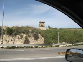
erected on the northern hill.
14:30 The Israeli police stopped a Palestinian car before the village of Asira al Kabaliyya to ticket it.
14:35 A military jeep drives toward us from the junction of Highway 60 and the Huwwara-Burin road.
We wait at that junction behind a military Hummer for a break in the traffic so we can both turn north toward the Huwwara checkpoint.
14:39 Huwwara checkpoint
Soldiers stationed in the observation tower at the checkpoint, the guard tower at the hitchhiking station at the exit from the Beracha settlement and the hitchhiking station at the settlement’s entrance.
Stones have been arranged in the form of a low wall
on the fence at the Huwwara checkpoint – where the
adjacent area has recently been “upgraded” – and carob trees have been planted, opposite the plaza that has also been “ungraded” – Who paid for the work? What’s it for?
It’s too bad Obama hadn’t been there and didn’t see with his own eyes how the settlements surrounding Nablus are choking the city.
There’s only one notice now on the fence from which the signs posted by the settlers were recently removed: “New localities in Judea and Samaria. To join, call [phone number]. The Nahalasettlement movement.”
14:40 A military truck turns toward the Huwwara DCO.
14:42 Awarta checkpoint
Closed as usual. No access to Nablus.
A military truck next to a military firing range located on the way to the village of Huwwara.
14:45 Beit Furik checkpoint
A minibus driver coming from Beit Dajan says that occasionally the army unexpectedly sets up flying checkpoints at the entrance to the village.
15:05 An army jeep drives through the village of Huwwara.
15:30 Za’tara checkpoint
Soldiers relax in the parking lot. No inspections.
16:00 The bus terminal at the Oranit settlement
We waited to see whether the police arrive. The police have been in the habit of making Palestinians get off the bus and not allowing them to continue. The police didn’t come. Let’s hope that continues. In any event, we’ll keep checking.
16:50 Azzun Atma checkpoint.
There was no congestion while we were there as laborers returned home through the checkpoint.
'Azzun 'Atma
See all reports for this place-
'Azzun 'Atma
A Palestinian village of about 1,800 residents. The settlement of Sha'arei Tikva was established on its land adjacent to it, and the settlement of Oranit was established on its agricultural lands. By 2013, the separation fence had passed through the village and a checkpoint staffed by the army allowed the residents to cross from side to side. After building a massive wall surrounding the village and some of its agricultural lands, the residents went daily for five years to their lands that remained in the Seam Zone through the Oranit agricultural checkpoint (4). Since 2018 it has only opened during the olive harvest and the farmers have to pass daily at the Beit Amin / Abu Salman checkpoint (1447), about 3 kilometers north.From a report from March 24, 2021: "The farmers from Beit Amin and Azon Atma are happy that since February 21 the Oranit checkpoint .is going to be open 3 times a day, The farmers are really developing the place."
Report from July 14, 2024: "Ornit checkpoint is closed . The Beit Amin/Abu Salman agricultural checkpoint is closed (there is no contact with the military to check if it opens rarely), the Ezbat Jaloud checkpoint was opened once a day before the war.
Updated for July 2024
 Apr-11-2019Azoun: The main entrance to village blocked now for several weeks
-
Beit Furik checkpoint
See all reports for this place-
One of the three internal checkpoints that closed on the city of Nablus - Beit Furik to the east, Hawara to the south, Beit Iba to the west. The checkpoint is located at the junction of Roads 557 (an apartheid road that was forbidden for Palestinians), leading to the Itamar and Alon Morea settlements and Road 5487. The checkpoint was established in 2001 for pedestrians and vehicles; The opening hours were short and the transition was slow and very problematic.Allegedly, the checkpoint is intended to monitor the movement to and from Nablus of the residents of Beit Furik and Beit Dajan, being the only opening outside their villages. Since May 2009 the checkpoint is open 24 hours a day, the military presence is limited, vehicles can pass through it without inspections, except for random inspections. (Updated April 2010)
-
Habla
See all reports for this place-
Habla CP (1393)
The Habla checkpoint (1393) was established on the lands of the residents of Qalqilya, on the short road that
connected it for centuries to the nearby town of Habla. The separation barrier intersects this road twice and cut off the residents of Qalqilya from their lands in the seam zone.(between the fence and the green line).
There is a passage under Road 55 that connects Qalqilya to the sabotage This agricultural barrier is used by the farmers and nursery owners established along Road 55 from the Green Line and on both sides of the kurkar road leading to the checkpoint.
This agricultural checkpoint serves the residents of Arab a-Ramadin al-Janoubi (detached from the West Bank), who pass through it to the West Bank and back to their homes. The opening hours (3 times a day) of this agricultural checkpoint are longer than usual, about an hour (recently shortened to 45 minutes), and are coordinated with the transportation hours of a-Ramadin children studying in the occupied in the West Bank. Nina SebaAug-18-2025Habla: The gate is in the process of closing
-
Za'tara (Tapuah)
See all reports for this place-
Za'tara (Tapuah) Za'tara is an internal checkpoint in the heart of the West Bank, at the intersection of Road 60 and Road 505 (Trans-Samaria), east of the Tapuah settlement. This checkpoint is the "border" marked by the IDF between the north and south of the West Bank, in accordance with the policy of separation between the two parts of the West Bank that has been in place since December 2005. At the Za'tara checkpoint, there are separate routes for Israelis and Palestinians. In the route for Israelis, there are no inspections and the route for Palestinians inspects. The queue lengthens and shortens suits. The checkpoint is open 24 hours a day. The checkpoint is partially staffed and the people who pass through it are checked at random.
 Ronit Dahan-RamatiJun-9-2026Za'atara (Tapuach Junction). The Temple Flag Above a Station
-