
Beit Furik, Burin (Yitzhar), Eliyahu Crossing, Shomron Crossing, Za’tara (Tapuah)
9:30 We entered through the Eliyahu Gate into Road 55. The area seemed quiet: today no jeeps were observing the village of Burin.On the to-us-closed part of road 555, leading to Shchem, many taxis and several buses were busy carrying Palestinians to Ramallah, Jerusalem and/or to Jericho.
We soon heard about some new upsetting incidents. First, Nadim told us that the “Esh Kodesh” outpost settlers had again burnt and stolen Palestinian property in Kusra.
The second incident occurred at the ex-checkpoint at Beit Furik. As we passed it, we noticed signs of burning and graffiti  . Palestinian drivers told Nadim that yesterday, Saturday 15.03, a young boy had burnt car tires near the column, and above that, had painted graffiti signs in red ink.
 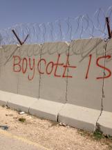 In our photos one can identify ashes of tires on the ground; the graffiti on the column proclaim:
“BOYCOTT ISRAEL” in English, with corresponding Arabic words.
We are told that for some 2-3 hours on Saturday, Zahal closed the Checkpoints, stopping and checking cars.
As we were leaving after examining the site, a military jeep arrived.
We passed Beita on road 60 (to left, direction Rosh Haayn) we witnessed yet a third incident: A long line of cars waiting to enter the village, was blocked by a Border Police (Mishmar Hagvul) jeep. Drivers and a shop worker, to whom Nadim spoke, asking what had happened, told him that this was a reaction to a recent stone-throwing incident, A situation similar to recurring ones in Azzun. Since then, the Border Police jeep has been coming once a week, checks the cars going out of Beita for some time, and then leaves. In this narrow side-road, this quickly causes a traffic jam for incoming cars. Sadly, the faces of the waiting drivers betrayed no emotion whether of anger, rebellion or impatience. These Palestinians seem to be resigned to a recurring situation over which they have no control.
Tappuach Junction presented the usual configuration: the trempiada to Ramallah was watched by two Border Police soldiers, and the road to Shchem by another two; while the straw-covered “butkes” or look-out positions, placed on tall columns, stood empty
12:00 We return through Shomron gate.
Beit Furik checkpoint
See all reports for this place-
One of the three internal checkpoints that closed on the city of Nablus - Beit Furik to the east, Hawara to the south, Beit Iba to the west. The checkpoint is located at the junction of Roads 557 (an apartheid road that was forbidden for Palestinians), leading to the Itamar and Alon Morea settlements and Road 5487. The checkpoint was established in 2001 for pedestrians and vehicles; The opening hours were short and the transition was slow and very problematic.Allegedly, the checkpoint is intended to monitor the movement to and from Nablus of the residents of Beit Furik and Beit Dajan, being the only opening outside their villages. Since May 2009 the checkpoint is open 24 hours a day, the military presence is limited, vehicles can pass through it without inspections, except for random inspections. (Updated April 2010)
-
Burin (Yitzhar)
See all reports for this place-
Burin (Yitzhar)
This is a Palestinian village in the Nablus governorate, a little south of Nablus, on the main road passing through the West Bank. The settlements: Yitzhar and Har Bracha, settled in locations that surrounded the village, placed fences so it is cut off the main road.
There are around 4000 inhabitants. Most of them are engaged in agriculture and pasture, although many graduates of the two secondary schools continue to study at the university. Academic positions are hardly available, they find work as builderd, or leave for the Gulf countries.
The village lands were appropriated several times for the establishment of Israeli settlements and military bases, and as a result, Burin's land and water resources dwindled. lSince 1982, more than 2,000 dunams of village land have been declared "state land" and then transferred to Har Bracha settlement.
Over the past few years and more so since 2017, the villagers have been terrorized by the residents of Yitzhar and Har Bracha, the Givat Ronen outpost and others. Despite the close proximity of soldiers to an IDF base close to one of the village's schools, residents are suffering from numerous stone-throwing events, vehicle and fire arson, also reported in the press.
In 2023, the prevention of the olive harvest in the village plot was more violent than ever. Soldiers and settlers walked with drawn weapons between the houses of the village and demanded that people stop harvesting in the village itself and in the private plots outside the village. The settlers from Yitzhar and Giv'at Roned raided the olive groves and stole crops. 300 olive trees belonging to the residents of Burin, near Yitzhar, were uprooted. The loss of livelihood from the olives causes long-term economic damage to the farmers' families, bringing them to the point of starvation.
(updated for November 2023)
-
Eliyahu CP (109) / Crossing
See all reports for this place-
Eliyahu CP (109) / Crossing This checkpoint, also known as the Fruit Crossing, is one of the main checkpoints between Israel and the West Bank. It is located on Route 55 between Alfei Menashe and the turn to Qalqilya and Zufin, more than 4 km east of the Green Line, in the separation fence, which separates Qalqilya from its lands to the south, thus leaving Alfei Menashe West of the fence - the Seam Zone. This checkpoint, a few kilometers across the Green Line, is intended for "Israeli settlement in the West Bank and the population of the Seam Zone." It is managed by a civil company. Palestinians with a special permit for their lands in the seam area are also allowed to pass through it, on foot, and sometimes by car.
-
Shomron Crossing
See all reports for this place-
Shomron Crossing The Shomron checkpoint for vehicles. is located east of Rosh HaAyin and Kafr Qassem, on Road 5 (Trans-Samaria) leading to Ariel and the Za'atara junction. It is intended for blue ID cardholders, foreign guests or diplomats, and international organizations only. In 2009 the management was entrusted to a civil security company.
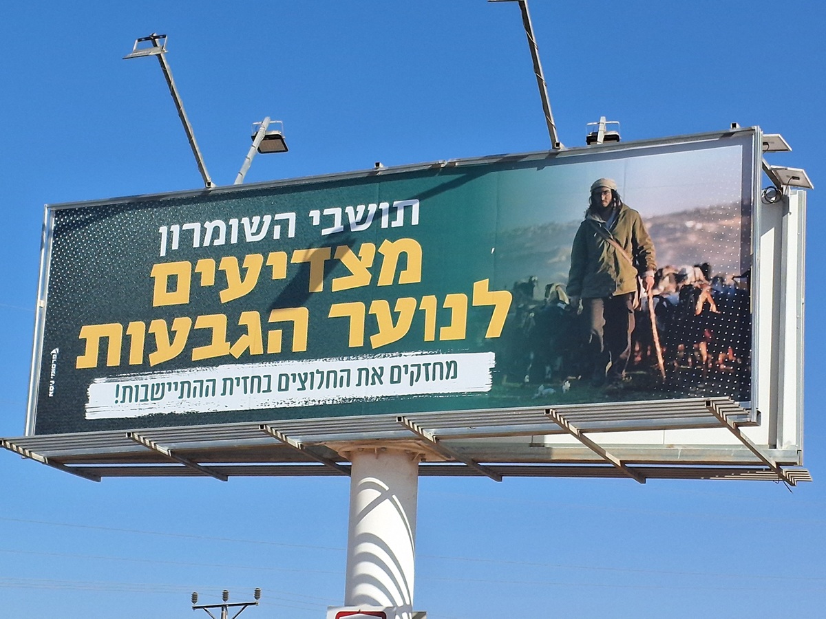 Ronit Dahan-RamatiAug-21-2025Highway 505: Salute to the Hilltop Youth
-
Za'tara (Tapuah)
See all reports for this place-
Za'tara (Tapuah) Za'tara is an internal checkpoint in the heart of the West Bank, at the intersection of Road 60 and Road 505 (Trans-Samaria), east of the Tapuah settlement. This checkpoint is the "border" marked by the IDF between the north and south of the West Bank, in accordance with the policy of separation between the two parts of the West Bank that has been in place since December 2005. At the Za'tara checkpoint, there are separate routes for Israelis and Palestinians. In the route for Israelis, there are no inspections and the route for Palestinians inspects. The queue lengthens and shortens suits. The checkpoint is open 24 hours a day. The checkpoint is partially staffed and the people who pass through it are checked at random.
 Ronit Dahan-RamatiJun-9-2026Za'atara (Tapuach Junction). The Temple Flag Above a Station
-