
Checkpooints in Hebron
Route 60
The weather is gray and cold, little traffic.
Dura-Al-Fawwar intersection – the kiosks were dismantled, and the planks were thrown to the ground.
The new outpost in front of Eshtamoa, which is marked by a large flag, is expanding and 4 buildings are already visible in the area.
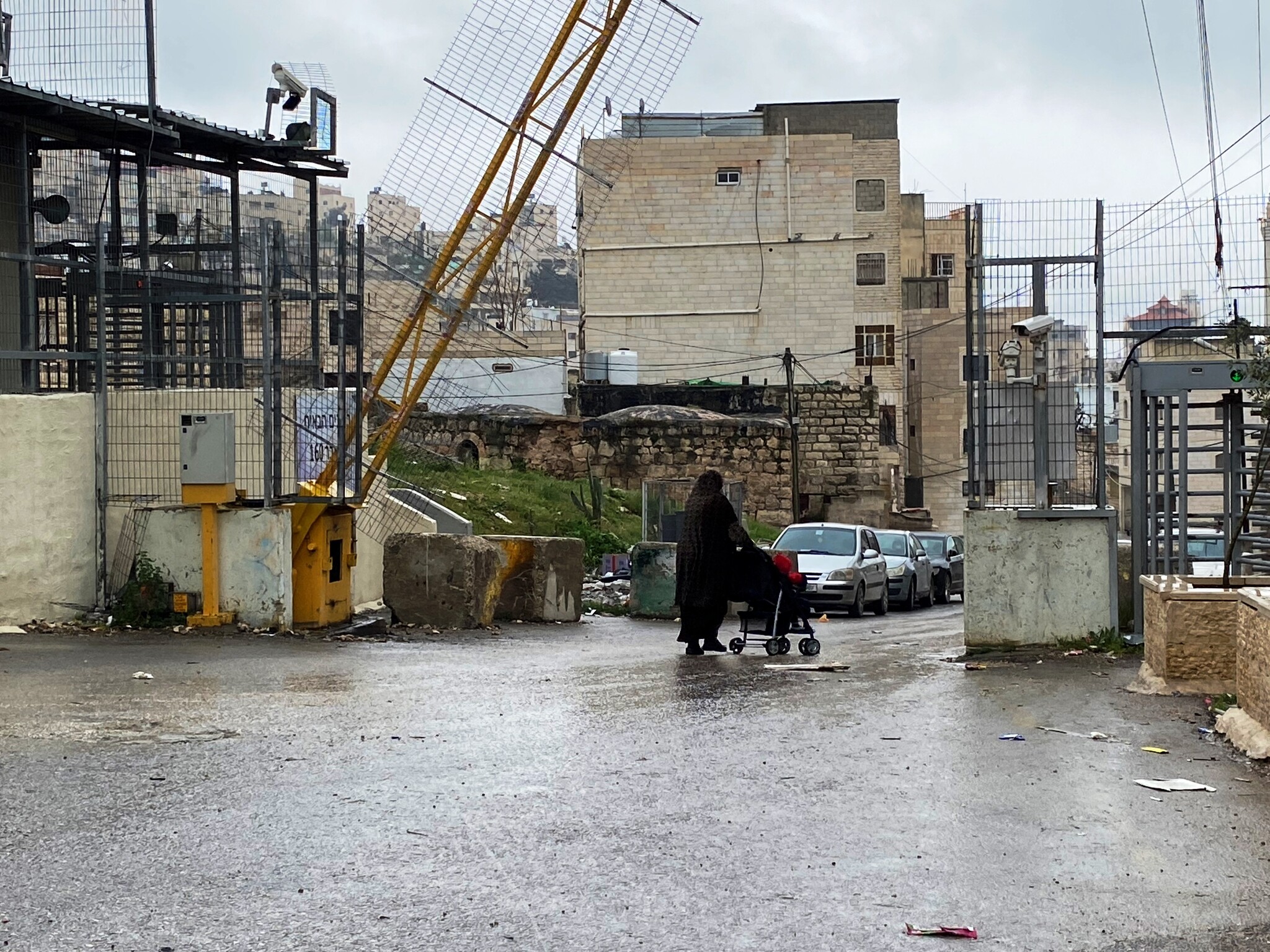
Hebron
Cold, rainy and quiet.
The paratroopers’ Shfifon unit is now in the city. The soldiers are gathered in huts because of the weather. Those not on duty enjoy Anat Cohen’s free hot drink stand near Beit Hadassah.
We go to to the grocery store in Tel Rumaida to leave an envelope for the neighbour, Bassam.
On the way down, the checkpoint, Tarpat, has renewed its appearance, receiving new names in each of the languages, the most prominent being the “policeman’s checkpoint”.
A closed gate has been placed on the stairs going down from the Córdoba school and only the residents of the area above are allowed to go up or down the stairs. We witnessed a long interrogation of a woman by the soldier at the post . Only after she gave her name, her ID number and her number on the list of residents was she allowed to pass, the soldier opened the gate for her.
In front of the wholesale market we met a group of teenagers from Germany, tourists who were being guided in Germany by a man who introduced himself as an archaeologist living in Jerusalem.
We met another group of tourists at the souvenir shop of the late Abed. Their guide from Beit Sahur explained to us that there is always work, everyone comes for a tour of Hebron – which allows for a nutshell illustration of the conflict.
We finished checking the checkpoints at the 160 turn – the gate was opened to allow a woman with a baby carriage to pass, more easily than through the turnstiles.
Route 317
A colourful and large mosque was built at the Zif junction.
In front of the Carmel settlement, a large area was fenced off, posts were inserted and a vineyard was probably planted.
The settlement of Asael expands towards the east, terraces have been erected for construction, and a dirt road has been paved for the new neighbourhood.
The illegal sheep farms of Kaplan and Yinon are becoming more established and new buildings are added. Abu Safi reports that Kaplan and Yinon regularly go down with their sheep to graze on the lands of the Palestinians.
At the Meitar checkpoint, the parking lot is full of cars even though not all farmers work in this kind of weather. This time we went through a more serious interrogation and document check than usual by a (probably new) policeman who didn’t like it that we defined ourselves as friends of Mohammad.
Dura Al-Fawwar Junction
See all reports for this place-
Junction on Route 60: west - the town of El Dura, east - the Al Fawwar refugee camp. There is a manned pillbox at the junction. From time to time the army sets up flying checkpoints at the entrance to El Fawwar and Al Dura. Al-Fawwar is a large refugee camp (7,000 inhabitants in 2007) established in 1949 to accommodate Palestinian refugees from Be'er Sheva and Beit Jubrin and environs. There are many incidents of stone-throwing. In the vicinity of the pillbox there are excellent agricultural areas, Farmers set up stalls adjacent to the plots close to the road. In recent months the civil administration has set up dirt embankments thereby blocking access to the stalls, and making it impossible for the farmers to sell their vegetables. Updated April 2021, Michal T.
-
Hebron
See all reports for this place-
According to Wye Plantation Accords (1997), Hebron is divided in two: H1 is under Palestinian Authority control, H2 is under Israeli control. In Hebron there are 170,000 Palestinian citizens, 60,000 of them in H2. Between the two areas are permanent checkpoints, manned at all hours, preventing Palestinian movement between them and controlling passage of permit holders such as teachers and schoolchildren. Some 800 Jews live in Avraham Avinu Quarter and Tel Rumeida, on Givat HaAvot and in the wholesale market.
Checkpoints observed in H2:
- Bet Hameriva CP- manned with a pillbox
- Kapisha quarter CP (the northern side of Zion axis) - manned with a pillbox
- The 160 turn CP (the southern side of Zion axis) - manned with a pillbox
- Avraham Avinu quarter - watch station
- The pharmacy CP - checking inside a caravan with a magnometer
- Tarpat (1929) CP - checking inside a caravan with a magnometer
- Tel Rumeida CP - guarding station
- Beit Hadassah CP - guarding station
Three checkpoints around the Tomb of the Patriarchs
 Muhammad D.May-13-2026Hebron - Request for compensation for land expropriation
-
Meitar checkpoint / Sansana
See all reports for this place-
Meitar Checkpoint / Sansana The checkpoint is located on the Green Line and serves as a border crossing between Israel and the West Bank. It is managed by the Border Crossing Authority of the Defense Ministry. It is comprised of sections for the transfer of goods as well as a vehicle checkpoint (intended for holders of blue identity cards, foreign nationals or diplomats and international organizations). Passing of Palestinians is prohibited, except for those with entry permits to Israel. Palestinians are permitted to cross on foot only. The crossing has a DCO / DCL / DCL / DCL (District Coordination Office), a customs unit, supervision, and a police unit. In the last year, a breach has been opened in the fence, not far from the crossing. This breach is known to all, including the army. There does not appear to be any interest in blocking it, probably as it permits needed Palestinian workers without the bureaucratic permits to get to work in Israel. Food stalls and a parking area economy have been created, but incidents of violent abuse by border police have also been recorded. Updated April 2022
-
South Hebron Hills
See all reports for this place-
South Hebron Hills
South Hebron Hills is a large area in the West Bank's southern part.
Yatta is a major city in this area: right in the border zone between the fertile region of Hebron and its surroundings and the desert of the Hebron Hills. Yatta has about 64,000 inhabitants.
The surrounding villages are called Masafer Yatta (Yatta's daughter villages). Their inhabitants subsist on livestock and agriculture. Agriculture is possible only in small plots, especially near streams. Most of the area consists of rocky terraces.Since the beginning of the 1980s, many settlements have been established on the agricultural land cultivated by the Palestinians in the South Hebron Hills region: Carmel, Maon, Susia, Masadot Yehuda, Othniel, and more. Since the settlements were established and Palestinians cultivation areas have been reduced; the residents of the South Hebron Hills have been suffering from harassment by the settlers. Attempts to evict and demolish houses have continued, along with withholding water and electricity. The military and police usually refrain from intervening in violent incidents between settlers and Palestinians do not enforce the law when it comes to the investigation of extensive violent Jewish settlers. The harassment in the South Hebron Hills includes attacking and attempting to burn residential tents, harassing dogs, harming herds, and preventing access to pastures.
There are several checkpoints in the South Hebron Hills, on Routes 317 and 60. In most of them, no military presence is apparent, but rather an array of pillboxes monitor the villages. Roadblocks are frequently set up according to the settlers and the army's needs. These are located at the Zif Junction, the Dura-al Fawwar crossing, and the Sheep Junction at the southern entrance to Hebron.
Updated April 2022
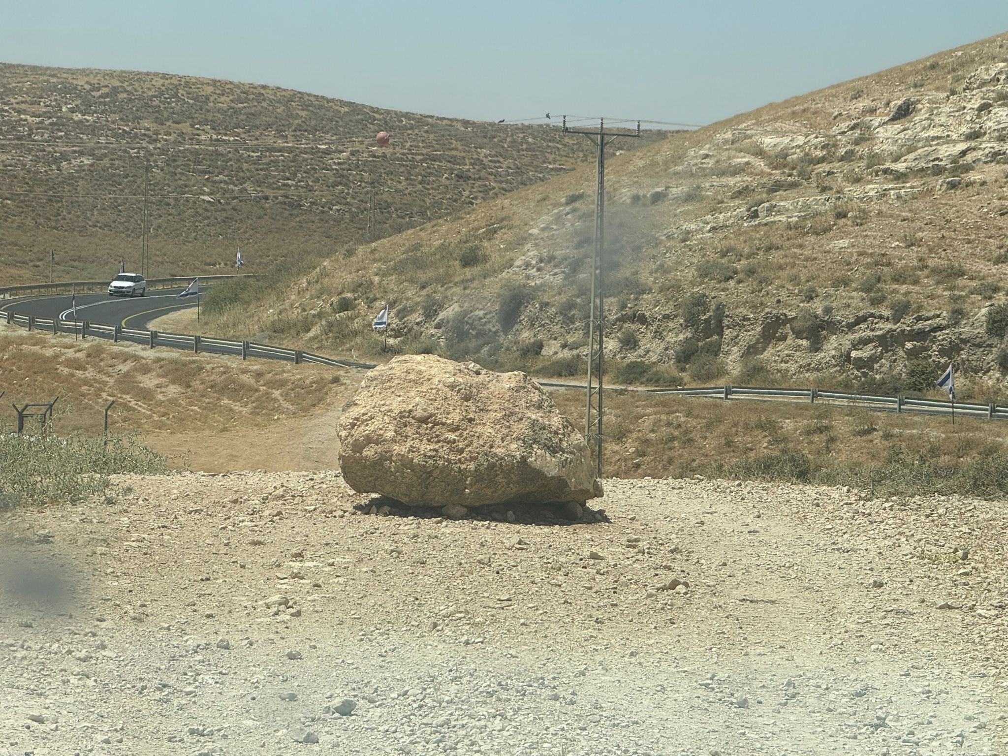 Muhammad D.Jun-7-2026A stone placed by settlers on the road leading to the Thiel family's territory in Rahwa
-
Zif Junction
See all reports for this place-
Zif Junction located on the crossroads that directs towards Road 356 to Yata. Yata is the district city of the southern Hebron Mountains. Usually, this junction is open to traffic. The nearby pillbox is unmanned. But the army and police are present occasionally, sometimes setting up a checkpoint and sometimes detaining residents from the big city. Often, the Israeli policemen inspect vehicles and distribute driving reports to Palestinian vehicles. s
-