
Deir Ballut
“Deir” is Arabic for “monastery.” “Deir Balut” is the “Monastery of the Oak.” Between Kufr a-Dik and Deir Balut are three Byzantine sites whose names begin with “Deir”: Deir Sam’an, Deir Kle’a and Deir el-Mir, comprising monasteries and agricultural lands indicated on British archaeological maps from 1944.
These maps were well-known to those who planned and built Ariel – and the Department of Archaeology of Ariel University – and Barkan and Bruchin and Alei Zahav and Leshem and Fadu’el. A massive bloc of settlements arranged in anticipation of an arrangement to “exchange territories,” etc.
We want to disrupt this unstated arrangement. To point out that the archaeological sites of Deir el-Mir and Deir Kle’a are imprisoned in the Padu’el settlement, and that the young settlement of Leshem, an offshoot of the veteran Alei Zahav settlement, has trapped Deir Sam’an.
We focused this time on Deir Sam’an, imprisoned in Leshem. Until a year and a half ago Palestinians from Deir Balut and Kufr a-Dik (one of whose residents owns the lands of Deir Sam’an) could visit the site. No longer!
Access to the site requires an Israeli ID card. The checkpoint is the same one for entering Alei Zahav. The new road to the new Leshem neighborhood is still open. When construction of the neighborhood is complete a checkpoint will be erected. The settlement of Alei Zahav has become two: Alei Zahav and Leshem.
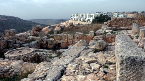
We drove to the site via Alei Zahav, heading toward Leshem. The site is extraordinary, like none I’ve ever seen on the West Bank. Huge presses that apparently produced wine, exported far and wide during the Byzantine period. The Byzantine period (324-638 CE) overlaps with the period of the Mishnah (70-638 CE). Two religions whose adherents were dedicated wine lovers. The size of the presses and cisterns is evidence of the impressive scope of production and development. All the other remains at the site, including the mosaic floor and a stone basin with a drain, indicate the presence of an advanced, elaborate culture.
We returned to Highway 446 and very quickly reached the outskirts of Deir Balut. At the small meat processing plant at the entrance, managed by a person who spoke fluent Hebrew (which he learned from Israeli TV) we were referred to D., the landowner. He described to us the village’s difficult situation.
It has 5000 residents. About 2000 have left, most to the United States. Only 12,000 of the original 36,000 dunums remain. All the land is in Area C, except for 740 dunums in Area B.
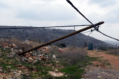
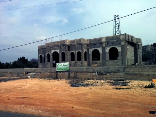
When they wanted to widen a road, to seal a pit, and to build fences against wild boars, the Civil Administration refused permission. From 2015 construction of a number of buildings was stopped, including a mosque located directly opposite the new neighborhood being built in Leshem. Abut 300-400 meters from D’s home rises a mountain of stones unloaded by trucks which every ten minutes return to dump their loads on Deir Balut’s olive groves.
D. accompanied us to the dump site. Electric poles had been broken and uprooted. The power line lies on the ground, felled by the rocks being dumped from the trucks. They will form the base of a terrace on which Leshem’s security fence will be installed. Red Cross staff from France were already on site, standing, like me, speechless.
We started inquiring about who owns the lands of the archaeological sites in Deir Balut and Kufr a-Dik. As usual, we’ll cooperate with the archaeologists who were in Burin that day and who met at the municipality with Munir, from Yesh Din, and with the head of the municipality, regarding the demand to provide villagers access to the Salaman el-Parsi maqam.
The trucks dump rocks on the olive trees and the power line. Photos and video by Nurit:
Kufr a-Dik
See all reports for this place-
Kufr a-Dik This is a Palestinian village in the Salfit district of the West Bank, located 8 kilometers east of the Green Line. The village population numbers 4,494 (as of 2007). 14.5% of the village were included in Area B (supposedly under Palestinian civil control) and 86% categorized as Area C – meaning both civil and military Israeli control, which severely affects the state of the village and its inhabitants. Over the years Israel has robbed 1,448 dunams from the village’s farmlands for the sake of building the settler-colonies of Penuel, Alei Zahav, Yoezer, Har Alei Zahav, and the industrial zone next to Penuel. Lands were also sequestered for the paving of Road 446 whose length stretches over 4 kilometers and includes a buffer zone 75-meters wide on both its sides. Following the paving of the road, the village has suffered not only landgrab but home demolitions and the destruction of water wells as well. Rates of unemployment in both the private and the public sectors reach 60%. In the years 2010-2013 creative activity was held by members of MachsomWatch and women of the village. For further information: http://vprofile.arij.org/salfit/pdfs/vprofile/Kafr%20ad%20Dik_tp_en.pdf
-
