
Dura-Al Fawwar Junction, Hebron, South Hebron Hills, Susiya
Road 60
Many soldiers at the crossroads. At the entrance to Samoa are soldiers with their vehicles. At the entrance to el Fawwar there are soldiers at the post and they are armed from head to foot. At the entrance to Bani Naim is a rolling checkpoint.
On the way we spoke to Farid Jabarin who tried to return to his lands in Susiya and was attacked by settlers. He was worried for his children and rented a home in Yatta
Hebron
Many soldiers guarding various workers working on the foundations in the area of the Route of the Worshippers
Next to the wholesale market …abandoned. Settlers renovate an area around an abandoned house.
When we stopped to photograph, a settler comes up to us and aggrersivelly bangs on the windshield and wants to know if we need help. He says that we are photographing and he needs to know what we want. We answered that we had photographed the house and not him or his friends. He mutters something in doubt but goes away.
At the area of Beit Hadassah Noam Arnon smiles a certain sort of smile and asks if we have photographed him and the settlers enough. He asks cynically. I said that it was impossible to forget him and he is known worldwise. He too mutters something about what we are and goes away.
At the end of the Kapisha neighborhood the checkpoint has again been moved and more and more cement fences and a yellow bar have been added. It is not clear why this work is being done but of course it adds to the despair.
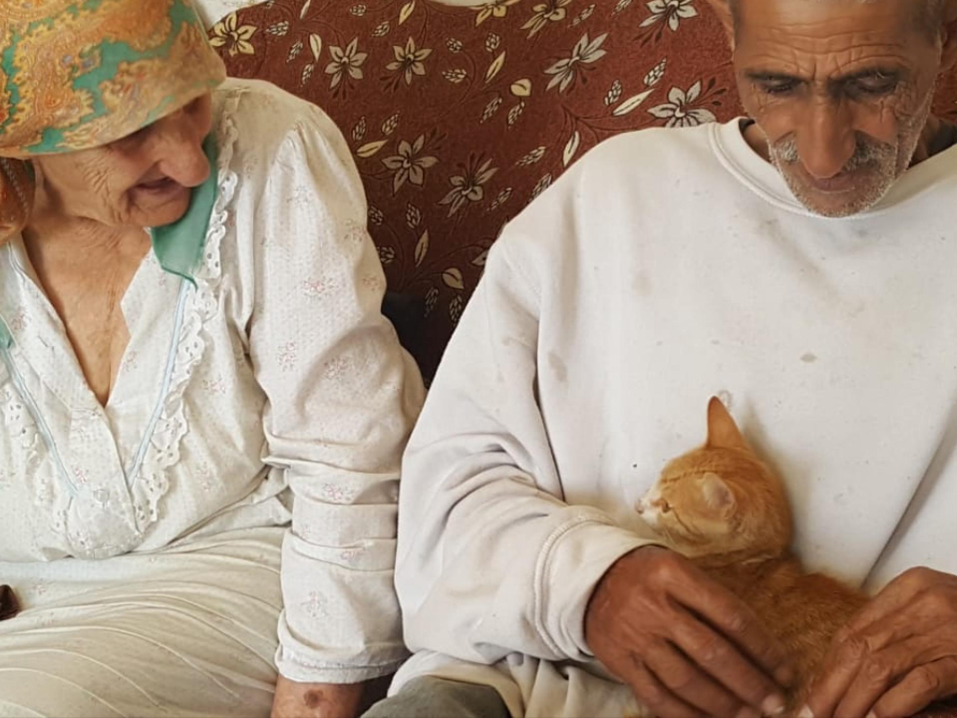
We went to visit Ata Jabar who had gone through hell and back with no end in sight because the Civil Administration and the settlers have an eye on his land. The plan to create territorial continuity between all neighborhoods of Kiryat Arba is clear.
His face is creased with wrinkles, no teeth, seems 30 years older than he is and pets with love and affection his cat which had disappeared.
How much love does this man have despite his hard life, for his cats and dogs. He says that they have a better life than he has. He tells us that on the 15th of January he received a summons to court concerning his land for the January 28th. His lawyer who had been appointed by the Palestinian Authority accepted the invitation and did not go.
On February 22nd, people from the administration, the army, the police, and sources who claimed that he had stolen water came.They sealed the water cistern and broke the taps and drips on a 4 dunam plot of land which ishis by right. The whole orchard with the nuts, the almonds, the grapes, the plums the tomatoes, the cabbage, the turnips and the zucchini are dry. Now his house is surrounded only by dry vegetation and suddenly you can see it from afar.
Nothing is left.
He is waiting for the help of various legal entities who promised him assistance. His attorney appointed by the PA is not exactly functioning.
I wrote to Dov Hanin and am waiting for an answer. I will continue to try to connect him with whoever is possible, when I return from overseas in about ten days.
If anyone has an idea for assistance, I would be happy to receive it. When we left, people came from a European organization that helped them repair the water system and other needs.
Lucky for him and for our shame.
Dura Al-Fawwar Junction
See all reports for this place-
Junction on Route 60: west - the town of El Dura, east - the Al Fawwar refugee camp. There is a manned pillbox at the junction. From time to time the army sets up flying checkpoints at the entrance to El Fawwar and Al Dura. Al-Fawwar is a large refugee camp (7,000 inhabitants in 2007) established in 1949 to accommodate Palestinian refugees from Be'er Sheva and Beit Jubrin and environs. There are many incidents of stone-throwing. In the vicinity of the pillbox there are excellent agricultural areas, Farmers set up stalls adjacent to the plots close to the road. In recent months the civil administration has set up dirt embankments thereby blocking access to the stalls, and making it impossible for the farmers to sell their vegetables. Updated April 2021, Michal T.
-
Hebron
See all reports for this place-
According to Wye Plantation Accords (1997), Hebron is divided in two: H1 is under Palestinian Authority control, H2 is under Israeli control. In Hebron there are 170,000 Palestinian citizens, 60,000 of them in H2. Between the two areas are permanent checkpoints, manned at all hours, preventing Palestinian movement between them and controlling passage of permit holders such as teachers and schoolchildren. Some 800 Jews live in Avraham Avinu Quarter and Tel Rumeida, on Givat HaAvot and in the wholesale market.
Checkpoints observed in H2:
- Bet Hameriva CP- manned with a pillbox
- Kapisha quarter CP (the northern side of Zion axis) - manned with a pillbox
- The 160 turn CP (the southern side of Zion axis) - manned with a pillbox
- Avraham Avinu quarter - watch station
- The pharmacy CP - checking inside a caravan with a magnometer
- Tarpat (1929) CP - checking inside a caravan with a magnometer
- Tel Rumeida CP - guarding station
- Beit Hadassah CP - guarding station
Three checkpoints around the Tomb of the Patriarchs
 Muhammad D.May-13-2026Hebron - Request for compensation for land expropriation
-
South Hebron Hills
See all reports for this place-
South Hebron Hills
South Hebron Hills is a large area in the West Bank's southern part.
Yatta is a major city in this area: right in the border zone between the fertile region of Hebron and its surroundings and the desert of the Hebron Hills. Yatta has about 64,000 inhabitants.
The surrounding villages are called Masafer Yatta (Yatta's daughter villages). Their inhabitants subsist on livestock and agriculture. Agriculture is possible only in small plots, especially near streams. Most of the area consists of rocky terraces.Since the beginning of the 1980s, many settlements have been established on the agricultural land cultivated by the Palestinians in the South Hebron Hills region: Carmel, Maon, Susia, Masadot Yehuda, Othniel, and more. Since the settlements were established and Palestinians cultivation areas have been reduced; the residents of the South Hebron Hills have been suffering from harassment by the settlers. Attempts to evict and demolish houses have continued, along with withholding water and electricity. The military and police usually refrain from intervening in violent incidents between settlers and Palestinians do not enforce the law when it comes to the investigation of extensive violent Jewish settlers. The harassment in the South Hebron Hills includes attacking and attempting to burn residential tents, harassing dogs, harming herds, and preventing access to pastures.
There are several checkpoints in the South Hebron Hills, on Routes 317 and 60. In most of them, no military presence is apparent, but rather an array of pillboxes monitor the villages. Roadblocks are frequently set up according to the settlers and the army's needs. These are located at the Zif Junction, the Dura-al Fawwar crossing, and the Sheep Junction at the southern entrance to Hebron.
Updated April 2022
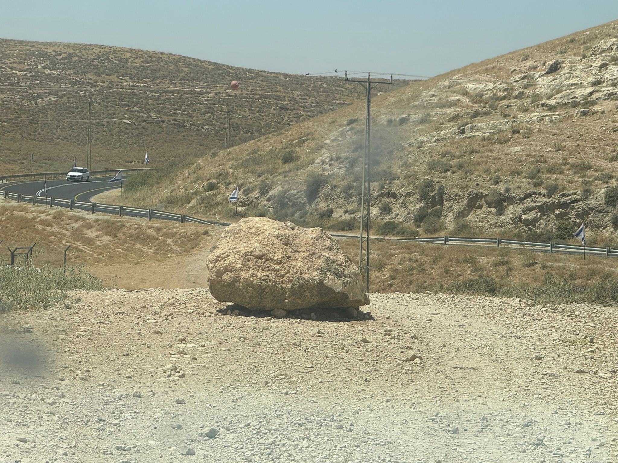 Muhammad D.Jun-7-2026A stone placed by settlers on the road leading to the Thiel family's territory in Rahwa
-
Susiya
See all reports for this place-
Susiya The Palestinian area lies between the settlement of Susya and a military base. The residents began to settle in areas outside the villages in the 1830s and lived in caves, tents and sukkot. To this day they maintain a traditional lifestyle and their livelihood is based on agriculture and herding. Until the 1948 war, the farmers cultivated areas that extended to the Arad area. As a result of the war, a significant portion of their land left on the Israeli side was lost. After the 1967 war and the Israeli occupation, military camps were established in the area, fire zones and nature reserves were declared, and the land area was further reduced. The Jewish settlement in Susya began in 1979. Since then, there has been a stubborn struggle to remove the remains of Palestinian residents who refuse to leave their place of birth and move to nearby town Yatta. With the development of a tourist site in Khirbet Susya in the late 1980s (an ancient synagogue), dozens of families living in caves in its vicinity were deported. In the second half of the 1990s, a new form of settlement developed in the area - shepherds' farms of individual settlers. This phenomenon increased the tension between the settlers and the original, Palestinian residents, and led to repeated harassment of the residents of the farms towards the Palestinians. At the same time, demolition of buildings and crop destruction by security forces continued, as well as water and electricity prevention. In the Palestinian Susya, as in a large part of the villages of the southern Hebron Mountains, there is no running water, but the water pipe that supplies water to the Susya Jewish settlement passes through it. Palestinians have to buy expensive water that comes in tankers. Solar electricity is provided by a collector system, installed with donation funds. But the frequent demolitions in the villages do not spare water cisterns or the solar panels and power poles designed to transfer solar electricity between the villages. Updated April 2021, Anat T.
-