
Hamra (Beqaot), Tayasir, Yasuf, Za’tara (Tapuah)
The green spaces on this summery winter day invite pastoral poetry (1). But they camouflage the Israeli control that holds on to the Jordan Valley. The 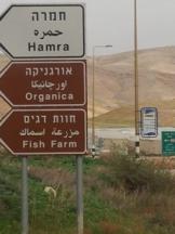 control carried out by the transfer of Israeli population and the establishment of colonies in the Valley began a relatively short time after the 1967 war (2), and today it is translated into demands for possession as a condition for an agreement between Israel and Palestine (3).
The data on the gaps between the Palestinian residents of the Valley and/ or owners of the land and the Jewish colonists are published and well-known (4). But there is a need to recall them when everything looks so pastoral, when the view is dotted with herds of sheep that the Palestinians are watching over, with Palestinian farmers who are putting up nurseries for the colonists' extension of their agricultural lands, and the construction of new colonies. An additional memo are the signs that point to the farm for growing fish, including fish for aquariums, while the Palestinians suffer because of a dire lack of water.
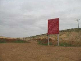
The Hamra and the Tyasir CPs are a concrete memo of the occupation and for this there are rules and regulations that favor Jews and discriminate against the Palestinians separating people on the basis of their national-ethnicity. Thus, there are also red signs throughout the area announcing that it is very dangerous to travel on the roads that lead to Area A.
In the picture on the left, the Gukhiya CP, opposite the colony of Ro'i, on the road that leads to the town of Tamoun.
9:17 Za'atara / Tapuach Junction – Palestinian cars are inspected in the parking space. People are sitting and waiting outside their vehicles. We did not see whether there was a dog on patrol. At the station for traveling to the village of Tapuach (the road that also leads to the Palestinian Yasouf) there are soldiers on an observation post.
9:30 – The Ma'ale Efraim CP is not manned.
9:50 Hamra CP – Cars coming from the direction of Nablus are waiting for instructions to advance to the CP, but, they go through quickly and their passengers remain inside. The same procedure is seen for the cars going in the opposite direction.
13:34 – Za'atara – Unmanned posts. There are no vehicles in the parking lot.
[1] למשל, http://www.youtube.com/watch?v=A0Q0FH0RW8A
Hamra (Beqaot)
See all reports for this place-
One of the Jordan Rift Valley checkpoints that prevent direct transit between the West Bank and the Jordan Valley, in addition to Tayasir Checkpoint. Located next to Hamra settlement, on Route 57 and the Allon Road.
Read about the peple of the Jordan Valley and the quiet transfer happening there.
 Shahar ShilohNov-3-2021Ein Shibli: grazing begins close to home
-
Tayasir CP
See all reports for this place-
Located on road 5799, It is one of the checkpoints control the passage between the northern West Bank and the Jordan Valley. For a long time, it stood empty and open, with only a sign next to it warning against entering Area A. It was adjacent to an old military camp - now everything is neglected. How much money was invested here, and how much brainwashing was done to the soldiers of Netzah Yehuda and Kfir.
Today, it is very difficult to pass there. Many delays. Often, teachers from Tubas are not allowed to pass into the Valley to villages like Ein al-Bida where the local schools are located, and there are no classes. There are additional days when the checkpoint is closed. In general, there is a wait there of about two to four hours to go towards the Valley and also to return. Many times the Palestinians are forced to use the Hamra checkpoint, which also leads into Tubas and the West Bank, but there is also a huge queue there and a long wait.
Following a deadly attack on soldiers at the nearby base in February 2025, the checkpoint was completely closed for the time being. (Updated March 2025)
-
Yasuf
See all reports for this place-
Yasuf The village numbers 2,500 residents, and in the neighboring village of Iskaka about 1,500. Yasuf suffers from low water supply and intermittent flow - although the population has more than doubled since the Oslo Accords, the 12 cubic meters set in 1996, sometimes even less, are alternated between the two villages, summer and winter .Permits to complete the harvest are only given for a few days, and there are often roadblocks on the way to the groves and the settlers, mostly fr/om Tapuah, try to drive the harvesters away. Since 2006, the settlements have been expanded threefold from their original location, and the harassments are numerous - including vandalism of cars and spraying of hate-inscriptions on the mosque. The settlers from Kfar Tapuach took control of land belonging to the residents and planted their own trees, and the army does not allow the villagers to approach these plots.
-
Za'tara (Tapuah)
See all reports for this place-
Za'tara (Tapuah) Za'tara is an internal checkpoint in the heart of the West Bank, at the intersection of Road 60 and Road 505 (Trans-Samaria), east of the Tapuah settlement. This checkpoint is the "border" marked by the IDF between the north and south of the West Bank, in accordance with the policy of separation between the two parts of the West Bank that has been in place since December 2005. At the Za'tara checkpoint, there are separate routes for Israelis and Palestinians. In the route for Israelis, there are no inspections and the route for Palestinians inspects. The queue lengthens and shortens suits. The checkpoint is open 24 hours a day. The checkpoint is partially staffed and the people who pass through it are checked at random.
 Ronit Dahan-RamatiJun-9-2026Za'atara (Tapuach Junction). The Temple Flag Above a Station
-
