
Hebron, Sansana (Meitar Crossing), South Hebron Hills
Sansana-Meitar crossing
06:15 At the Meitar crossing we met the international volunteers; they’ve been at the checkpoint since 03:50. It was already open. Palestinians told them it had opened at 03:30, which made them all happy. Everyone reports that people are going through quickly; 5000 had crossed by now. People continued arriving while we were present; there are no lines.
We left and drove towards Othniel at 06:34.
Southern Hebron Hills
06:52 Dura-al Fawwar junction: A flying checkpoint, soldiers inspecting IDs. Since it’s rush hour, there’s always a line of 10-12 cars.
The observation balloon floats over Beit Haggai.
The southern entrance to Hebron is open; there are no soldiers at the checkpoint.
Hebron
The Tel Rumeida excavation has been expanded; an additional area has been fenced. We peeked in. The archaeologist digging there on behalf of the Antiquities Authority, David Ben Shlomo (he confirmed he’s the son of Prof. Ben Shlomo, from the department of Jewish Thought), explained pleasantly that there are places where the excavation has reached bedrock, others where they’ve reached Bronze Age strata (the end of the period of Israelite kingship – approximately the time of Hezekiah) which is the period to which the walls of ancient Hebron uncovered in 1999 in Tel Rumeida are dated, and also a typical Israelite house, and even an earlier Bronze Age period. He has no idea what will happen to the area after the excavation is over.
Farther south along the ridge (the entrance to the path leading to Michael’s house) are the same signs in Arabic on the fence. They’ll also dig there. They’re indifferent to the restrictions caused to the movement of Palestinians who live there. In fact, the buildings for the archaeological dig have already been erected.
At 07:30, when we were at the Pharmacy junction, we heard a “BOOM;” the international volunteers telephoned to tell us soldiers had fired a tear gas grenade at children. We drove down to Curve 160 to find out what happened. Border Police soldiers refused to talk to us; they referred us to the Border Police spokesperson.
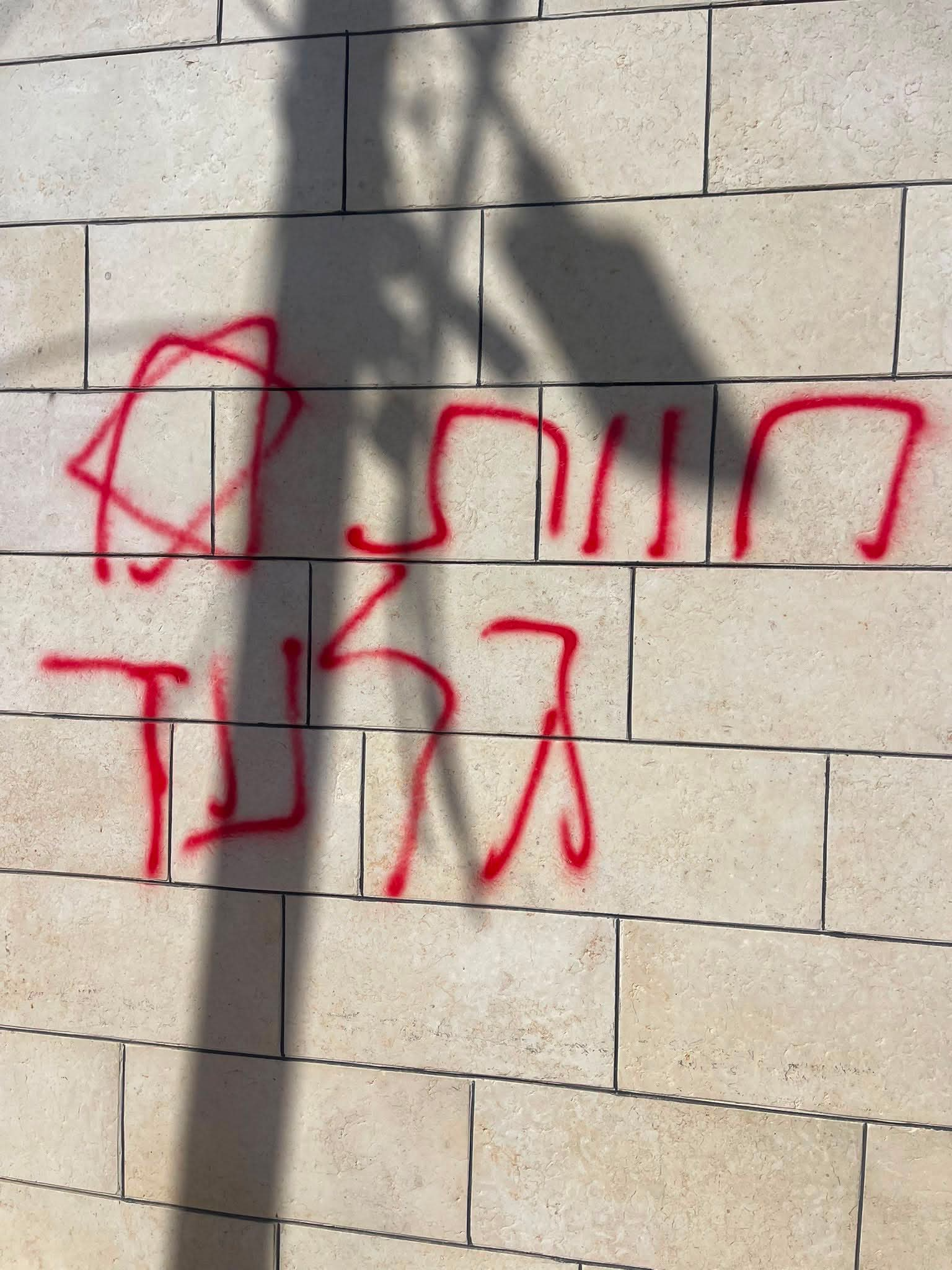
A charming, very Jewish graffiti on the concrete barrier at Curve 160 (which the international volunteers call “Checkpoint 29”). The commander of the Border Police situation room is on site. He describes himself as “in charge of all checkpoints in the expanded area around the Cave of the Patriarchs.” He referred us to the Border Police spokesperson for information about the incident. But one of the soldiers sent me to see swastikas in the lane leading off from the road a little farther on. The swastikas are drawn backward. The soldiers are looking for Nazis in order to justify their wrath at the town’s Palestinian residents. I think the Palestinians know that it’s an anti-Jewish symbol, but don’t know much more than that. As far as they’re concerned, it’s no more than a symbol of political protest.
Another flying checkpoint was erected next to the Yossi Shok memorial.
Hebron
See all reports for this place-
According to Wye Plantation Accords (1997), Hebron is divided in two: H1 is under Palestinian Authority control, H2 is under Israeli control. In Hebron there are 170,000 Palestinian citizens, 60,000 of them in H2. Between the two areas are permanent checkpoints, manned at all hours, preventing Palestinian movement between them and controlling passage of permit holders such as teachers and schoolchildren. Some 800 Jews live in Avraham Avinu Quarter and Tel Rumeida, on Givat HaAvot and in the wholesale market.
Checkpoints observed in H2:
- Bet Hameriva CP- manned with a pillbox
- Kapisha quarter CP (the northern side of Zion axis) - manned with a pillbox
- The 160 turn CP (the southern side of Zion axis) - manned with a pillbox
- Avraham Avinu quarter - watch station
- The pharmacy CP - checking inside a caravan with a magnometer
- Tarpat (1929) CP - checking inside a caravan with a magnometer
- Tel Rumeida CP - guarding station
- Beit Hadassah CP - guarding station
Three checkpoints around the Tomb of the Patriarchs
 Muhammad D.May-13-2026Hebron - Request for compensation for land expropriation
-
Meitar checkpoint / Sansana
See all reports for this place-
Meitar Checkpoint / Sansana The checkpoint is located on the Green Line and serves as a border crossing between Israel and the West Bank. It is managed by the Border Crossing Authority of the Defense Ministry. It is comprised of sections for the transfer of goods as well as a vehicle checkpoint (intended for holders of blue identity cards, foreign nationals or diplomats and international organizations). Passing of Palestinians is prohibited, except for those with entry permits to Israel. Palestinians are permitted to cross on foot only. The crossing has a DCO / DCL / DCL / DCL (District Coordination Office), a customs unit, supervision, and a police unit. In the last year, a breach has been opened in the fence, not far from the crossing. This breach is known to all, including the army. There does not appear to be any interest in blocking it, probably as it permits needed Palestinian workers without the bureaucratic permits to get to work in Israel. Food stalls and a parking area economy have been created, but incidents of violent abuse by border police have also been recorded. Updated April 2022
-
South Hebron Hills
See all reports for this place-
South Hebron Hills
South Hebron Hills is a large area in the West Bank's southern part.
Yatta is a major city in this area: right in the border zone between the fertile region of Hebron and its surroundings and the desert of the Hebron Hills. Yatta has about 64,000 inhabitants.
The surrounding villages are called Masafer Yatta (Yatta's daughter villages). Their inhabitants subsist on livestock and agriculture. Agriculture is possible only in small plots, especially near streams. Most of the area consists of rocky terraces.Since the beginning of the 1980s, many settlements have been established on the agricultural land cultivated by the Palestinians in the South Hebron Hills region: Carmel, Maon, Susia, Masadot Yehuda, Othniel, and more. Since the settlements were established and Palestinians cultivation areas have been reduced; the residents of the South Hebron Hills have been suffering from harassment by the settlers. Attempts to evict and demolish houses have continued, along with withholding water and electricity. The military and police usually refrain from intervening in violent incidents between settlers and Palestinians do not enforce the law when it comes to the investigation of extensive violent Jewish settlers. The harassment in the South Hebron Hills includes attacking and attempting to burn residential tents, harassing dogs, harming herds, and preventing access to pastures.
There are several checkpoints in the South Hebron Hills, on Routes 317 and 60. In most of them, no military presence is apparent, but rather an array of pillboxes monitor the villages. Roadblocks are frequently set up according to the settlers and the army's needs. These are located at the Zif Junction, the Dura-al Fawwar crossing, and the Sheep Junction at the southern entrance to Hebron.
Updated April 2022
 A Palestinian residentJul-19-2026Graffiti sprayed in A-Tuwani
-