
Hebron, Sansana (Meitar Crossing), South Hebron Hills, Sun 26.5.13, Morning
Meitar Passage – Sansana
06:00 a.m.
Near Kibbutz Kramim we are surprised to find a police checkpoint in both directions. Near the Meitar CP there is lively vehicle traffic – many workers and many employers. We crossed to the Palestinian side. The workers' passage is quick. The EAPPI people who are there told us that since early morning thirty people were refused entry into Israel. They do not know why, but those coming back do not appear to be angry. We asked one of the people coming back while we were talking and he said that his employer said he no longer has a permit for him. The man said that he will look for another employer.
On the hill that can be seen from the CP, there is a group of about 17 illegals waiting for an opportunity to descend and sneak into Israeli territory. After a short time we see smoke spreading toward them, a police unit is using tear gas. They retreat a bit, but continue to wait until the gas disappears. They keep standing there and waiting to try for luck. They take risks when they need to earn a livelihood; in a place where poverty if rife. What alternative do they have?
South Hebron Hills
We travel on a side road in the direction of Ramadin-Dahariah; Ramadin has a paved road with no CP. From there onwards to Burg: the road passes between a big cluster of beautiful large houses, cultivated fields, olive groves, nurseries, hen houses, schools. Far from the colonies' areas, the residents can conduct normal lives. almost. Bet Arusha- Alfuqa, beautiful view: lovely houses, many children going to school, in the fields they are now harvesting squash, but without water pipes and sprinklers they get the water from pools.
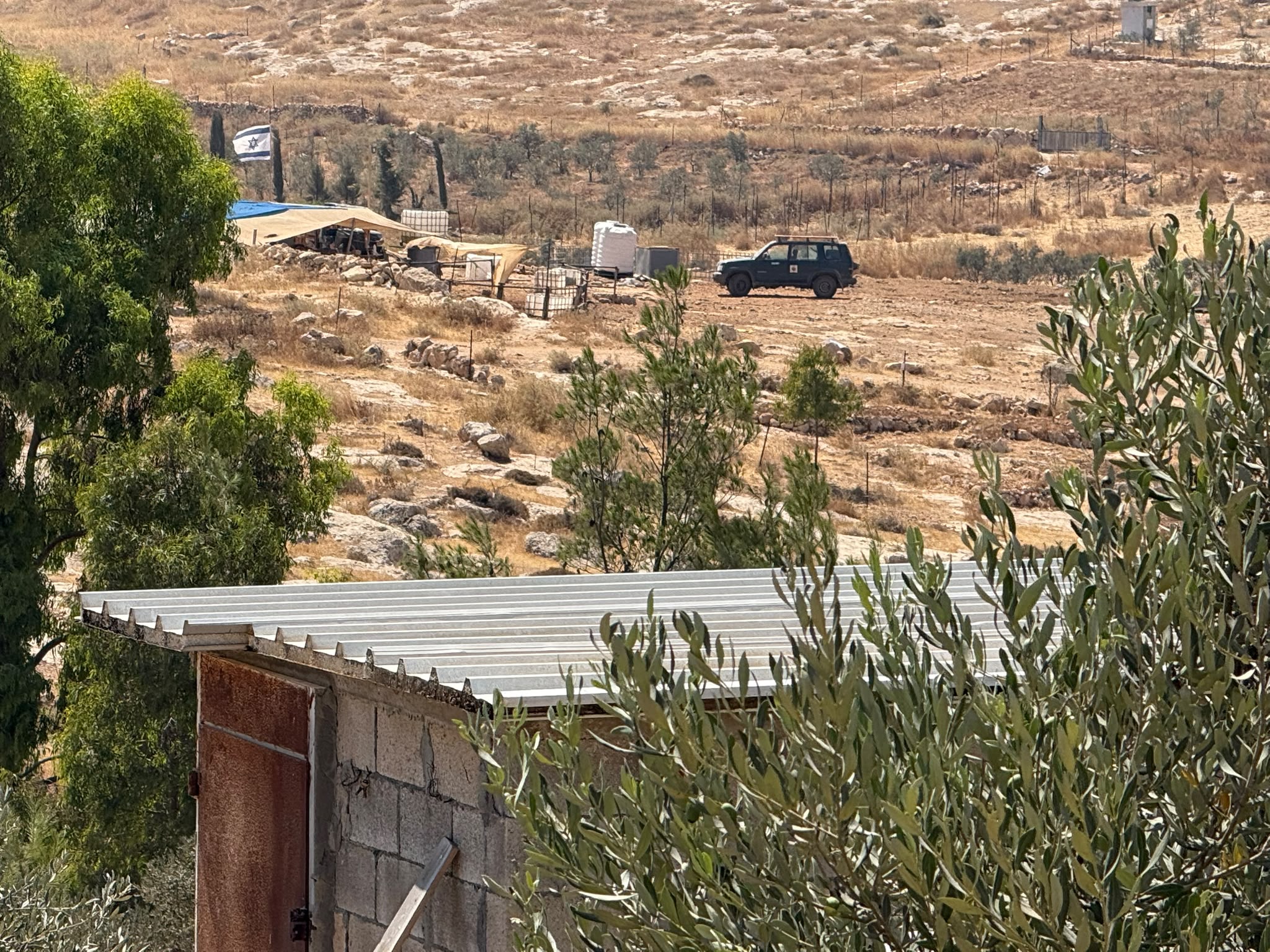
We turned to Negohot. Here the idyll ended and we returned to reality. Negohot B': a collection of caravillas on a hill and from a significant distance .from it there is Negohot A', also on a hill and constructed beautifully. In the colony they are preparing a large area for expansion, between B' and A' there are a few mobile CPs on the sides of the road.
El Fawwar – There is an army CP at the entrance, but the traffic is flowing.
Hebron:
We are halted at the Kiryat Arba CP; there is a telephone call and then we are allowed to go through. In Hebron it is 'quiet' this morning. The children are going to school quickly. Now is the period of final exams. Before we left, we went into the caravilla neighborhood on the Hill of Mamre. A gorgeous kindergarten has been built there; Near it they are building a large private house and beyond that there is a caravilla that became a stone house a long time ago. Continuing on the road there is a dirt road and they are preparing the ground. At the exit near the vineyards of Jabry, a small notice has been put on a pole, to the effect that there will be a ground-breaking ceremony for an educational center at Bnei Haver. It will be worthwhile to visit there.
South Hebron Hills
All along the road there are religious warnings about Nitzan Alon – 'Nitzan Alon (means ) no security'. On Road 317 there are archeological digs. The digs opposite Ma'on are deserted. Obviously the affair ended with nothing. Now it is possible to prepare the ground for expansion.
In the uprooted vineyard, the roots have been whitewashed and cut. Now the counting begins all over again. They have to wait six years until there will be fruit.
In Susiya, the new neighborhood is ready for residents and some more ground is being prepared for expansion.
On the way back, we see only one person on the 'hill of the illegals'.
Hebron
See all reports for this place-
According to Wye Plantation Accords (1997), Hebron is divided in two: H1 is under Palestinian Authority control, H2 is under Israeli control. In Hebron there are 170,000 Palestinian citizens, 60,000 of them in H2. Between the two areas are permanent checkpoints, manned at all hours, preventing Palestinian movement between them and controlling passage of permit holders such as teachers and schoolchildren. Some 800 Jews live in Avraham Avinu Quarter and Tel Rumeida, on Givat HaAvot and in the wholesale market.
Checkpoints observed in H2:
- Bet Hameriva CP- manned with a pillbox
- Kapisha quarter CP (the northern side of Zion axis) - manned with a pillbox
- The 160 turn CP (the southern side of Zion axis) - manned with a pillbox
- Avraham Avinu quarter - watch station
- The pharmacy CP - checking inside a caravan with a magnometer
- Tarpat (1929) CP - checking inside a caravan with a magnometer
- Tel Rumeida CP - guarding station
- Beit Hadassah CP - guarding station
Three checkpoints around the Tomb of the Patriarchs
 Muhammad D.May-13-2026Hebron - Request for compensation for land expropriation
-
Meitar checkpoint / Sansana
See all reports for this place-
Meitar Checkpoint / Sansana The checkpoint is located on the Green Line and serves as a border crossing between Israel and the West Bank. It is managed by the Border Crossing Authority of the Defense Ministry. It is comprised of sections for the transfer of goods as well as a vehicle checkpoint (intended for holders of blue identity cards, foreign nationals or diplomats and international organizations). Passing of Palestinians is prohibited, except for those with entry permits to Israel. Palestinians are permitted to cross on foot only. The crossing has a DCO / DCL / DCL / DCL (District Coordination Office), a customs unit, supervision, and a police unit. In the last year, a breach has been opened in the fence, not far from the crossing. This breach is known to all, including the army. There does not appear to be any interest in blocking it, probably as it permits needed Palestinian workers without the bureaucratic permits to get to work in Israel. Food stalls and a parking area economy have been created, but incidents of violent abuse by border police have also been recorded. Updated April 2022
-
South Hebron Hills
See all reports for this place-
South Hebron Hills
South Hebron Hills is a large area in the West Bank's southern part.
Yatta is a major city in this area: right in the border zone between the fertile region of Hebron and its surroundings and the desert of the Hebron Hills. Yatta has about 64,000 inhabitants.
The surrounding villages are called Masafer Yatta (Yatta's daughter villages). Their inhabitants subsist on livestock and agriculture. Agriculture is possible only in small plots, especially near streams. Most of the area consists of rocky terraces.Since the beginning of the 1980s, many settlements have been established on the agricultural land cultivated by the Palestinians in the South Hebron Hills region: Carmel, Maon, Susia, Masadot Yehuda, Othniel, and more. Since the settlements were established and Palestinians cultivation areas have been reduced; the residents of the South Hebron Hills have been suffering from harassment by the settlers. Attempts to evict and demolish houses have continued, along with withholding water and electricity. The military and police usually refrain from intervening in violent incidents between settlers and Palestinians do not enforce the law when it comes to the investigation of extensive violent Jewish settlers. The harassment in the South Hebron Hills includes attacking and attempting to burn residential tents, harassing dogs, harming herds, and preventing access to pastures.
There are several checkpoints in the South Hebron Hills, on Routes 317 and 60. In most of them, no military presence is apparent, but rather an array of pillboxes monitor the villages. Roadblocks are frequently set up according to the settlers and the army's needs. These are located at the Zif Junction, the Dura-al Fawwar crossing, and the Sheep Junction at the southern entrance to Hebron.
Updated April 2022
 Muhammad D.Jul-23-2026The new settlement, starting June 1, 2026, opposite Khallet al-Humus.
-
