
Hebron, South Hebron Hills
Road 317 was empty and windswept when we descended from it to a dirt road from which we were going to bring medicine to Abu Saif in Wadi Ramim. We saw from his house the terraces with his wheat on the other side of the wadi, some of which were eaten by the sheep sent by the settler Israel. Israel’s farm stands out on the ridge on the other side of the wadi but today he did not bring out the sheep to graze, perhaps due to the wind and dust in the air.
On the way to Hebron, at the junction with Road 60, a police checkpoint which checked every Palestinian car in the direction of Hebron. On our way back the checkpoint was no longer there.
A similar police checkpoint, backed by a female soldier with a drawn weapon and a police officer with an iPad! checked vehicle licenses at the entrance to the Kiryat Arba industrial zone. Of course, Israeli cars enter without inspection.
The Givati Brigade is now in Hebron. Increased military presence of both vehicles and groups of soldiers and groups of police officers seen at the briefing. Maybe ahead of Passover. Apart from them, the streets are empty and desolate.
The shops opposite the entrance to the Cave of the Patriarchs were opened, in some hope for tourists. So far none.
Hebron
See all reports for this place-
According to Wye Plantation Accords (1997), Hebron is divided in two: H1 is under Palestinian Authority control, H2 is under Israeli control. In Hebron there are 170,000 Palestinian citizens, 60,000 of them in H2. Between the two areas are permanent checkpoints, manned at all hours, preventing Palestinian movement between them and controlling passage of permit holders such as teachers and schoolchildren. Some 800 Jews live in Avraham Avinu Quarter and Tel Rumeida, on Givat HaAvot and in the wholesale market.
Checkpoints observed in H2:
- Bet Hameriva CP- manned with a pillbox
- Kapisha quarter CP (the northern side of Zion axis) - manned with a pillbox
- The 160 turn CP (the southern side of Zion axis) - manned with a pillbox
- Avraham Avinu quarter - watch station
- The pharmacy CP - checking inside a caravan with a magnometer
- Tarpat (1929) CP - checking inside a caravan with a magnometer
- Tel Rumeida CP - guarding station
- Beit Hadassah CP - guarding station
Three checkpoints around the Tomb of the Patriarchs
 Muhammad D.May-13-2026Hebron - Request for compensation for land expropriation
-
South Hebron Hills
See all reports for this place-
South Hebron Hills
South Hebron Hills is a large area in the West Bank's southern part.
Yatta is a major city in this area: right in the border zone between the fertile region of Hebron and its surroundings and the desert of the Hebron Hills. Yatta has about 64,000 inhabitants.
The surrounding villages are called Masafer Yatta (Yatta's daughter villages). Their inhabitants subsist on livestock and agriculture. Agriculture is possible only in small plots, especially near streams. Most of the area consists of rocky terraces.Since the beginning of the 1980s, many settlements have been established on the agricultural land cultivated by the Palestinians in the South Hebron Hills region: Carmel, Maon, Susia, Masadot Yehuda, Othniel, and more. Since the settlements were established and Palestinians cultivation areas have been reduced; the residents of the South Hebron Hills have been suffering from harassment by the settlers. Attempts to evict and demolish houses have continued, along with withholding water and electricity. The military and police usually refrain from intervening in violent incidents between settlers and Palestinians do not enforce the law when it comes to the investigation of extensive violent Jewish settlers. The harassment in the South Hebron Hills includes attacking and attempting to burn residential tents, harassing dogs, harming herds, and preventing access to pastures.
There are several checkpoints in the South Hebron Hills, on Routes 317 and 60. In most of them, no military presence is apparent, but rather an array of pillboxes monitor the villages. Roadblocks are frequently set up according to the settlers and the army's needs. These are located at the Zif Junction, the Dura-al Fawwar crossing, and the Sheep Junction at the southern entrance to Hebron.
Updated April 2022
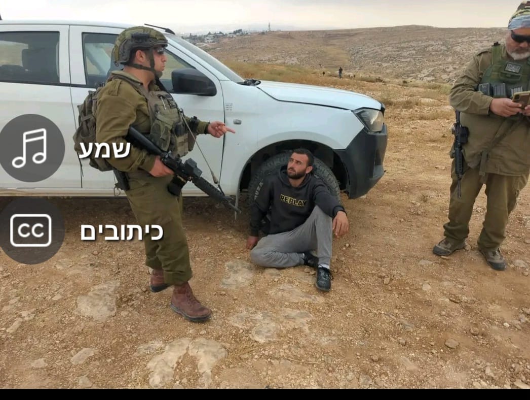 A Palestinian residentJul-6-2026Sha'ab al-Butum - M. and F. Jabarin arrested after settler attack on their home
-