
South Hebron Hill
1. After the Meitar crossing , right turn onto road 60: the army cleared trees and bushes south of the road, near the perimeter fence, to prevent the passage of illegal workers.
2. Further on, a view from the road north towards the Tene Omer settlement: on the right is an “old” settler farm, on the left is a new settler building. The takeover of lands continues
3. In front of Shim’a, on the other side of the road, a new sign in the direction of Havat Yehuda. The farm was near Eshtamoa and was moved a little south, also here – taking over more land. You can also see a tractor, another building, inside Eshtamoa.
4. Facing west from Highway 60 towards Dahariya, north of Otniel, cameras are installed. The work is carried out under the guard of the army.
5. Opposite the turn to the village Abda, a new bus station of the Netivei Israel company. The bus line numbers are not written on the station, and we wonder: do they stop here for Palestinians? At the station, Palestinians are observed perhaps waiting for Palestinian taxis.
6. Turn west towards Khursa. According to the many signs on businesses and workshops with inscriptions in Hebrew as well, it can be estimated that settlers use these cheap and efficient services – building materials, car maintenance.
7. Between Khursa and Ifkaikis, works by the Palestinian Authority to widen the road.
8. A visit to the Jadalla family, because we were asked to be in contact with them: this morning a settler from the Nagohot sheep farm passed with his herd through the family’s compound, as if they were air, and not for the first time. Mother Safia ran up the hill to hit him, he left when she threatened to call the police. Daughter Rania took a picture. (The herd looks healthy and well fed.…). We saw the man at the entrance to the farm: a young man in a sleeveless T-shirt, probably an employee of the farm owner. Muhammad takes down bags of clothes he brought with him, to distribute to families in the area.
9. Development work in the Negohot settlement, the trucks are unloading the building waste on the south side of the road in front of the family’s compound. These are also private lands of Palestinians from other families.
10. A truck is working on the sheep farm development works here as well. We came to Israel to build in it, but we probably did not come to build in it morally.
Meitar checkpoint / Sansana
See all reports for this place-
Meitar Checkpoint / Sansana The checkpoint is located on the Green Line and serves as a border crossing between Israel and the West Bank. It is managed by the Border Crossing Authority of the Defense Ministry. It is comprised of sections for the transfer of goods as well as a vehicle checkpoint (intended for holders of blue identity cards, foreign nationals or diplomats and international organizations). Passing of Palestinians is prohibited, except for those with entry permits to Israel. Palestinians are permitted to cross on foot only. The crossing has a DCO / DCL / DCL / DCL (District Coordination Office), a customs unit, supervision, and a police unit. In the last year, a breach has been opened in the fence, not far from the crossing. This breach is known to all, including the army. There does not appear to be any interest in blocking it, probably as it permits needed Palestinian workers without the bureaucratic permits to get to work in Israel. Food stalls and a parking area economy have been created, but incidents of violent abuse by border police have also been recorded. Updated April 2022
-
South Hebron Hills
See all reports for this place-
South Hebron Hills
South Hebron Hills is a large area in the West Bank's southern part.
Yatta is a major city in this area: right in the border zone between the fertile region of Hebron and its surroundings and the desert of the Hebron Hills. Yatta has about 64,000 inhabitants.
The surrounding villages are called Masafer Yatta (Yatta's daughter villages). Their inhabitants subsist on livestock and agriculture. Agriculture is possible only in small plots, especially near streams. Most of the area consists of rocky terraces.Since the beginning of the 1980s, many settlements have been established on the agricultural land cultivated by the Palestinians in the South Hebron Hills region: Carmel, Maon, Susia, Masadot Yehuda, Othniel, and more. Since the settlements were established and Palestinians cultivation areas have been reduced; the residents of the South Hebron Hills have been suffering from harassment by the settlers. Attempts to evict and demolish houses have continued, along with withholding water and electricity. The military and police usually refrain from intervening in violent incidents between settlers and Palestinians do not enforce the law when it comes to the investigation of extensive violent Jewish settlers. The harassment in the South Hebron Hills includes attacking and attempting to burn residential tents, harassing dogs, harming herds, and preventing access to pastures.
There are several checkpoints in the South Hebron Hills, on Routes 317 and 60. In most of them, no military presence is apparent, but rather an array of pillboxes monitor the villages. Roadblocks are frequently set up according to the settlers and the army's needs. These are located at the Zif Junction, the Dura-al Fawwar crossing, and the Sheep Junction at the southern entrance to Hebron.
Updated April 2022
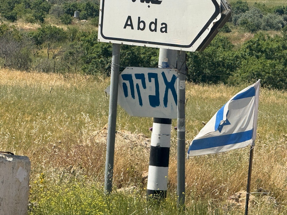 Leah ShakdielApr-29-2026South Hebron Hills. The turn to 'Afeka', one of the new outposts facing Abda
-