
South of Mount Hebron, Khorsa, a checkpoint to the center of the village
Meitar Checkpoint: Despite the fact that most of the workers had already crossed and the checkpoint was more crowded than usual, we found three groups of unfortunate 60 people on the Israeli side of the checkpoint. They were families on their way to visit people in prison, including children, women, and elderly people. They were unable to cross because only one bus had arrived. A worker from the Red Cross dealt with the matter and after much shouting and crying an additional bus was sent.
A group of older men were sitting under the shed, on the other side 3-4 young men and 3 soldiers from the border patrol who checked documents and told us that unfortunately (!) these were persons who had entered Israel illegally and that they were consequently being detained for investigation. When we asked about the other group we were told that they were “in order”. The older men told us that they had been checked and detained and that there had been no violence, and they were no waiting for transportation, but were not particularly happy.
We drove along Route 60 where traffic was heavier than usual. There was nothing new in Al Fawwar and we drove back to Khursa – a village with a population of about 5,000 people. The village has three schools, kindergartens, and a checkpoint at its center. The strange thing is that the checkpoint, which is a yellow gate like those in a civilian parking lot – is located in front of the social center of the village, known as the diwan, where the elderly people used to sit and watch what is going on. The entrance to the diwan has been closed for more than a year except for special occasions, and depends on prearranged permission. We visited the Yusef brothers – four discouraged people in a shop near the gate and the diwan. There is a steep slope to the left of the checkpoint leading down to an asphalt road that is open to traffic and pedestrians, but people cannot get to the diwan. We didn’t see any soldiers while we were there, but people told us that there were patrols of 15-18 soldiers.
The settlement of Negohot is located farther down the road we continued driving along the paved road to a checkpoint leading into Israel. There were lovely mountains and valleys along the way and we reached the checkpoint. Before we managed to show our ID cards an neglected little soldiers ordered us to go back. We pleaded and tried to convince him but to no avail, and we returned from where we had come from. Hagit Beck said that she had never been prevented from crossing the checkpoint Her claim that Arabs were not permitted to cross there unless they were accompanied by a Jewish person were verified with the Association for Civil Rights.
Dura Al-Fawwar Junction
See all reports for this place-
Junction on Route 60: west - the town of El Dura, east - the Al Fawwar refugee camp. There is a manned pillbox at the junction. From time to time the army sets up flying checkpoints at the entrance to El Fawwar and Al Dura. Al-Fawwar is a large refugee camp (7,000 inhabitants in 2007) established in 1949 to accommodate Palestinian refugees from Be'er Sheva and Beit Jubrin and environs. There are many incidents of stone-throwing. In the vicinity of the pillbox there are excellent agricultural areas, Farmers set up stalls adjacent to the plots close to the road. In recent months the civil administration has set up dirt embankments thereby blocking access to the stalls, and making it impossible for the farmers to sell their vegetables. Updated April 2021, Michal T.
-
Khursa / Al Marajem
See all reports for this place-
Khursa / Al Marajam
Khursa is a small village of about 2,500 inhabitants in Area A, on a hill on the way to Negohot settlement. At the end of September 2017, a pillbox watchtower was set up in the heart of the village, adjacent to the village's diwan, which is a sort of community center for celebrations such as weddings, or used as mourning tent. The army declared the place a closed military zone. In 2018, we saw another aggravation: a barrier of about 50 m, which divides the road into two, and a prohibition on passing vehicles, and then also a prohibition on pedestrians, who have to walk around on a dirt road - during winter on a mud road. Since the checkpoint was established, the army has required special permits to hold an event in Diwan and the permits must be requested at least two days in advance. Of course, the dying are not always cooperative ...together with the villagers we wondered what the meaning of this strange barrier in Area A, which is supposed to be under full control of the Palestinian Authority. Conclusion: It seems that in order to secure the way to the Negohot, the residents are forced to live with a closed military zone and a watchtower in the village center, and suffer many restrictions. (From Watch Checkpoint reports).
Recently, the Israeli authorities began, in the middle of the night, to pave a new bypass road from the nearby village Fuqeiqis to Negohot, Trying to establish facts and aiming to enlarge the settlement.
Updated in April 2021 by Anat T.
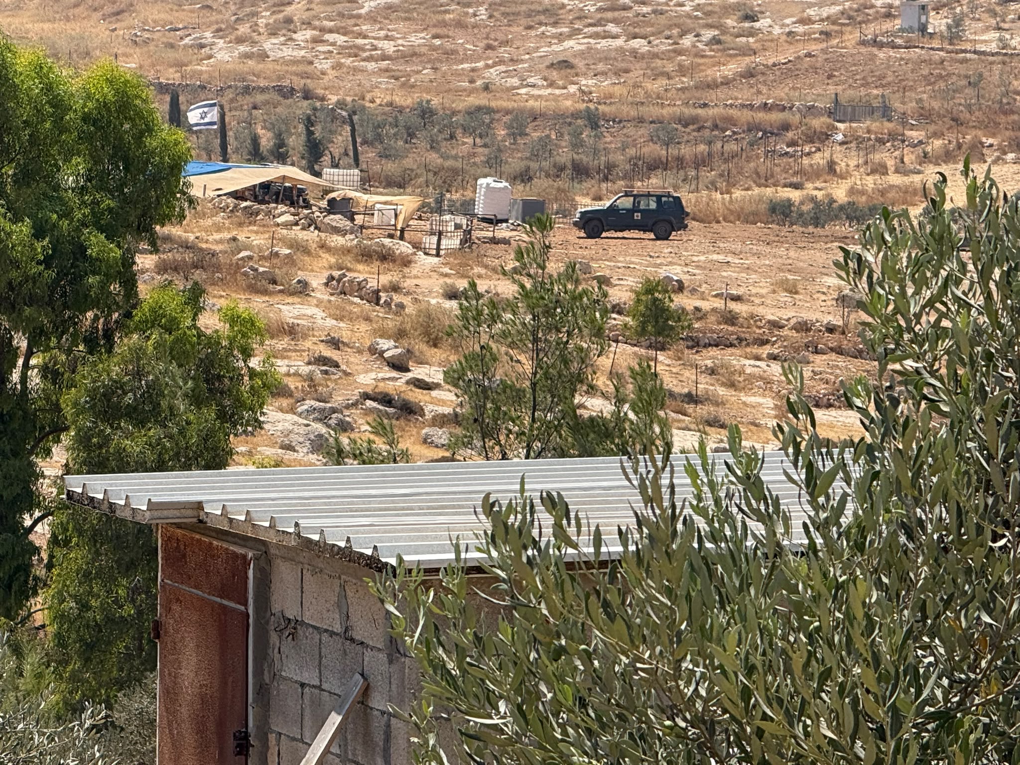 Muhammad D.Jul-23-2026The new settlement, starting June 1, 2026, opposite Khallet al-Humus.
-
Meitar checkpoint / Sansana
See all reports for this place-
Meitar Checkpoint / Sansana The checkpoint is located on the Green Line and serves as a border crossing between Israel and the West Bank. It is managed by the Border Crossing Authority of the Defense Ministry. It is comprised of sections for the transfer of goods as well as a vehicle checkpoint (intended for holders of blue identity cards, foreign nationals or diplomats and international organizations). Passing of Palestinians is prohibited, except for those with entry permits to Israel. Palestinians are permitted to cross on foot only. The crossing has a DCO / DCL / DCL / DCL (District Coordination Office), a customs unit, supervision, and a police unit. In the last year, a breach has been opened in the fence, not far from the crossing. This breach is known to all, including the army. There does not appear to be any interest in blocking it, probably as it permits needed Palestinian workers without the bureaucratic permits to get to work in Israel. Food stalls and a parking area economy have been created, but incidents of violent abuse by border police have also been recorded. Updated April 2022
-
South Hebron Hills
See all reports for this place-
South Hebron Hills
South Hebron Hills is a large area in the West Bank's southern part.
Yatta is a major city in this area: right in the border zone between the fertile region of Hebron and its surroundings and the desert of the Hebron Hills. Yatta has about 64,000 inhabitants.
The surrounding villages are called Masafer Yatta (Yatta's daughter villages). Their inhabitants subsist on livestock and agriculture. Agriculture is possible only in small plots, especially near streams. Most of the area consists of rocky terraces.Since the beginning of the 1980s, many settlements have been established on the agricultural land cultivated by the Palestinians in the South Hebron Hills region: Carmel, Maon, Susia, Masadot Yehuda, Othniel, and more. Since the settlements were established and Palestinians cultivation areas have been reduced; the residents of the South Hebron Hills have been suffering from harassment by the settlers. Attempts to evict and demolish houses have continued, along with withholding water and electricity. The military and police usually refrain from intervening in violent incidents between settlers and Palestinians do not enforce the law when it comes to the investigation of extensive violent Jewish settlers. The harassment in the South Hebron Hills includes attacking and attempting to burn residential tents, harassing dogs, harming herds, and preventing access to pastures.
There are several checkpoints in the South Hebron Hills, on Routes 317 and 60. In most of them, no military presence is apparent, but rather an array of pillboxes monitor the villages. Roadblocks are frequently set up according to the settlers and the army's needs. These are located at the Zif Junction, the Dura-al Fawwar crossing, and the Sheep Junction at the southern entrance to Hebron.
Updated April 2022
Muhammad D.Jul-23-2026The new settlement, starting June 1, 2026, opposite Khallet al-Humus.
-
