
The Container (Wadi Nar): Traffic jam into the West Bank – endless hours of driving and unexpected delays
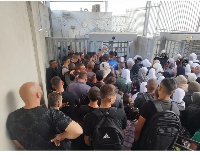
Sheikh Sa’ed checkpoint – Today is a school holiday for the birthday of Muhammad, so the checkpoint is empty. According to reports from neighborhood contacts, there is usually heavy congestion between 6:30 and 8:30 because of kushan checks (land registration documents) for all the students and because permits for teachers and students to cross at the Sawahreh al-Gharbiya checkpoint were revoked. Letters to the Jerusalem Municipality and to the Education Officer in the Civil Administration were of no use.
On the way, Hagit shows us a huge garbage mound blocking the course of Wadi Kidron in the Jabal Mukabber area. It turns out the municipality gave a private contractor permission to dump garbage and construction debris there. The stench is nauseating, right across from residents’ homes. One wonders about the municipal body established to preserve the Kidron stream and their stance regarding this. Apparently, it is of no interest to them.

We continue and turn at the fork in the road toward Wadi Qaddum. At the time, we thought we had identified a drilling site for the exit of the Sheikh Anbar tunnel (which will serve only Israelis, running from al-Tur to the southern American Road, to be dug about 100 meters beneath the neighborhoods of Abu Dis and Ras al-Amud). Yes, that’s it. For the first time we are seeing extensive works there with a backhoe and other heavy equipment near the planned tunnel exit. We also see the retaining wall for the road that will be paved to connect to the American Road.

We ascend to the Jericho road blocked in Abu Dis by the separation wall. There are no longer inscriptions or graffiti on the wall, which once served as a famous site for protest art. Hagit says that now, with the separation and the situation entrenched, Palestinians and human rights groups no longer have the energy to protest. In my eyes, that’s an indicator of Palestinian despair…
We arrive at the lookout from the hilltop near the Olive Checkpoint (Ras abu-Sbitan). The checkpoint itself closed at 9 in the morning until the next day, and there is no movement of people or transport vehicles .Hagit shows us where E1 bloc is located, 12 square kilometers where building was taboo for years until Smotrich’s government decided to ignore all international prohibitions and cut off, once and for all, the continuity of the future Palestinian state. The Palestinian’s own central region, with Jerusalem at its center, will be blocked, and building in E1 will effectively prevent Palestinians from traveling between the northern and southern West Bank.
As you’ll see in the video we filmed, Hagit explains that under this situation, anyone coming from Jericho and wanting to reach Bethlehem or Hebron will have to go through Ramallah, via narrow, steep, winding apartheid roads dotted with checkpoints.
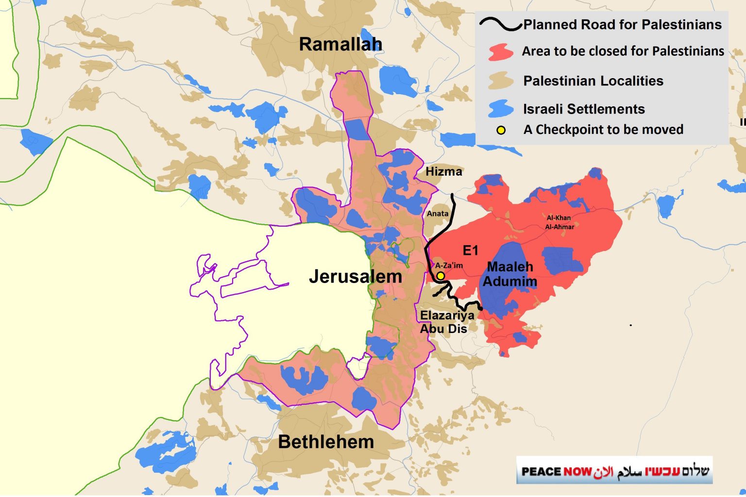
We continue to the entrance to al-Eizariya , opposite the entrance to Ma’ale Adumim, taking a long and partly steep detour to reach the Container checkpoint. (There is an excellent road leading in a short time from the Ma’ale Adumim–al-Eizariya junction to Wadi Nar, but the settlers of Kedar and Kedar B are not willing to allow Palestinians to use it.)
We knew we might face problems as we observe near the Container Checkpoint. For many years we observed there without issue, but times have changed. A few months ago we were detained there for more than an hour and a half, and now our driver refuses to go back after being subjected to a humiliating body search, which included a public counting of all the money in his possession—so that, according to the soldiers, they wouldn’t be accused of theft…
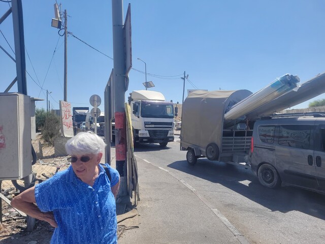
But in recent weeks we have received many complaints about hours-long delays at the checkpoint, and given its relevance to the E1 story, we decided this time to observe it from a greater distance, beyond the traffic circle leading to it.
· The checkpoint was completely jammed, specifically in the direction of exit toward the West Bank (why?—ask the settlers living in the southern West Bank). Trucks and large vehicles were stuck in the traffic circle and not moving. We photographed the congestion and spoke with the drivers who were trapped (some of them were traveling to celebrate the eve of the Prophet Muhammad’s birthday with their families). They were all in complete despair—“You can’t live like this! And it isn’t just today; you can never know what will be blocked and what won’t. Hours upon hours of travel and unexpected delays.”
We were surprised to see a male and female Border Police soldiers approach us. They asked if we knew we were in Area A, and how we got there. When we explained we had come from Azariya, they were aghast: “This is a red area, Area A, dangerous and forbidden for Israelis.” It was clear no one had explained to them the difference between Areas B, C, and A. They only knew of red Palestinian Area A and blue areas where Israelis can travel. They demanded that we come to the checkpoint, adding that a military vehicle would escort us to safety within minutes—out through Ma’ale Adumim. We considered simply leaving, but we went down to the checkpoint, and immediately our ID cards were taken and we were each photographed close-up.
We kept our composure so as not to escalate the drama and waste more time. But the delay dragged on, and when the command jeep with the officer arrived, our IDs were taken again and we waited for orders. Then we were escorted by the army as far as a yellow fenced checkpoint leading to the apartheid road from Kedar settlements to Ma’ale Adumim. Opening the gate took forever, and Natanya joked that they’d probably forgotten the key, but then the officer came down and told us we were being taken for questioning at the Ma’ale Adumim police station and had to hand over our IDs and phones. We refused to give our phones. Hagit called an appropriate lawyer and prepared her for the possibility that we’d be arrested.
Four armed soldiers, 2 male and 2 female, escorted us into the station. We asked if they didn’t find it ridiculous to be leading older women like us under guard; they remained stern-faced. After all, one must be very careful with traitorous leftists of any age…

As it turned out, the station commander was a little amused. He said he’d received a warning that women had been detained for being in the red area, Area A. Fortunately, Hagit calmly and kindly showed him on the Civil Administration map that Azariya is marked as Area B (Israeli security control, Palestinian municipal authority). He said that in his 12 years in the post, he had never seen such a map. The military maps of the area show only red and blue zones. He released us immediately, with an implicit warning not to come again.
The worst part was seeing the brainwashed pawn soldiers. This is where we’re at— the Border Police and the army’s face today is the face of Ben Gvir and Smotrich.
In the photo you see Natanya walking toward the entrance to the police station. Honestly, Natanya doesn’t hold back, and it was very hard for her to stay silent and not hurl a few choice expletives at our escorts… But she restrained herself, and we thank her from the bottom of our hearts.
Location Description
Container (Wadi Nar)
See all reports for this place-
Wadi Nar Checkpoint ("Container", "The Kiosk") - a barrier for vehicles in Area B that is regularly manned - east of Abu Dis between Sawahra A Sharqiya and Bethlehem and its daughters. Controls Palestinian movement between the north and south West-Bank. Includes driving routes, access roads, spikes, traffic lights and signs. There is no pedestrian crossing. Open 24 hours a day with random checks enhanced on security alerts. The checkpoint is in Palestinian territory, allowing for separation between the north and the south Palestinian areas when necessary.
In 2015, the leading road from Azaria to Bethlehem was renovated, as well as the steep and narrow ascent to the Wadi Nar checkpoint, which was dangerously travelled in both directions! The temporary checkpoint was renovated and expanded, and pedestrian traffic was banned. From 2016, traffic travelling from the south bank to Azaria was directed to a one-way road near the Southern Keydar Jewish settlement.
Machsomwatch shifts visit this far-fetched checkpoint only occasionally.
(updated to July 2019)
-
Ras Abu Sbitan (Olive Terminal)
See all reports for this place-
A large checkpoint/crossing to the area of a-Tur, Abu Dis and the Old City; only for pedestrians. Located on Jerusalem’s municipal boundary.
One of the major crossings in Jerusalem’s central sector. It is located on the separation fence between the northern portion of the al-Ezariya neighborhood and the neighborhood of a-Tur and the rest of East Jerusalem. It is manned by Border Police soldiers and private security companies and operates 24 hours a day. Palestinians are forbidden to go through, other than permanent residents of East Jerusalem (holders of blue ID cards) and holders of work and commercial permits who are allowed through only on foot.
-
Sheikh Sa'ed
See all reports for this place-
A checkpoint limited to pedestrians, located on Jerusalem’s municipal boundary.
The checkpoint sits on the separation fence at the entrance to Sheikh Sa’ad, dividing it from its neighbourhood of Jabel Mukkabar. It’s manned by Border Police soldiers and private security companies and operates 24 hours a day. Palestinians are forbidden to go through, other than residents of Jabel Mukkabar or Sheikh Sa'ad who have permits. Both groups are permitted through only on foot. Residents of East Jerusalem who don’t live in Jabel Mukkabar are also allowed to cross to Sheikh Sa’ad, but not in the opposite direction; they must return through the Sawahira ash Sharqiya checkpoint.
 Anat TuegMay-20-2026Nabi Samwil. This is what living conditions look like in an enclave village without building or renovation permits
-