
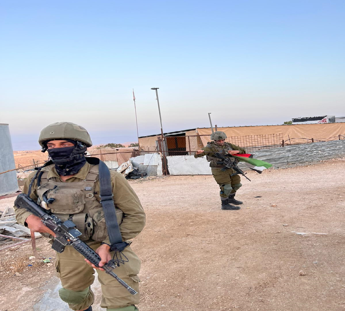
Umm al-Kheir – soldiers remove the Palestinian flag under false pretenses

Umm Al-Kheir at the turn off road 317, immediately after you pass the Carmel settlement, at the junction with road 356.
As we passed by the caravans of the Carmel settlement near the entrance to the village, we saw two female soldiers coming out of one of them and sweeping the area in front of them. We were surprised, but it turns out that female soldiers are regularly guarding the entrance to the settlement and change every two weeks.
We met in Umm al Kheir with two residents of the village, who, because of the fear of the security forces, asked not to be identified.
They briefly told the history of the place: the Hathalin family belongs to the Jahalin Bedouin community. Before the establishment of the state, they lived around the area of Tel Arad. With the establishment of the state, they were expelled, like most of the Bedouin in the Negev, and today they are scattered throughout the region up to the Dead Sea (the residents of Khan al-Ahmar are also from the Jahalin tribe).
They say that since the establishment of the new right-wing government, there has been a worsening of the attitude to them, and there is no limit to the harassment of the settlers. This part of the village lies right on the fence of Carmel. They asked the army and the DCO to replace the barbed wire fence that separates them from the settlement, because the barbed wire injures the sheep walking nearby, but they answered in the negative. The argument: no budget.
They say that a few days ago, four masked soldiers arrived, with the aim of taking down the Palestinian flag that was flying in the village. The soldiers said it was the flag of the Palestinian Authority (so far everything is true), and it should not be hoisted in this area, (Area C), because it is a territory that belongs to the State of Israel. Clarifying the issue of waving Palestinian flags with the UN representative in the territories revealed that as of January, a new law came into effect prohibiting the waving of Palestinian flags in Territory C. The reasoning – it’s a flag that creates a mess and disturbs public order. In the meantime, they did not hang another flag, in order to maintain peace, especially for the benefit of the children who are frightened by the presence of the army.
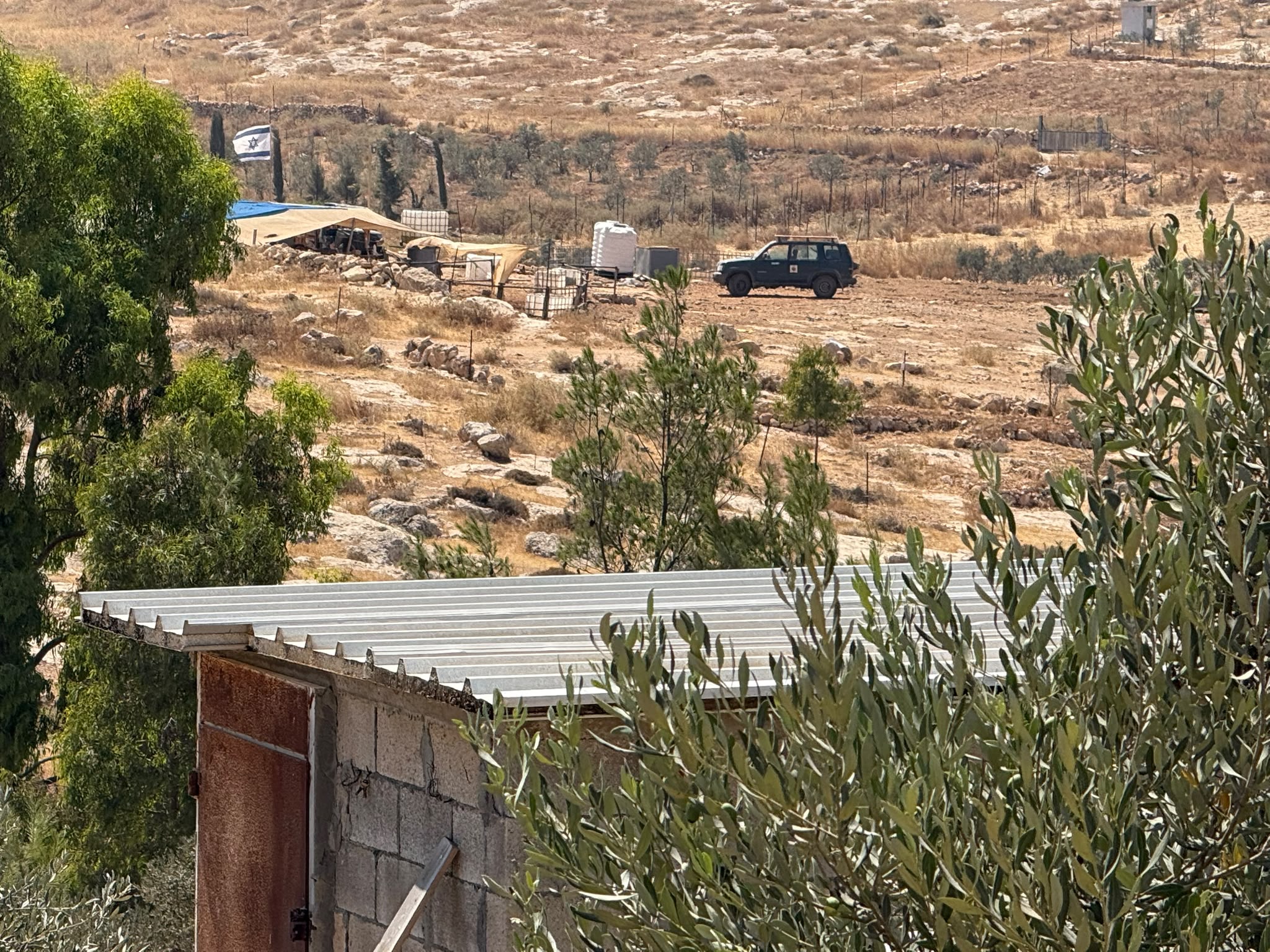
From Umm al-Kheir you can see the illegal outpost, Havat Mann, established a few years ago by Yael and Issachar Mann , east of the Maon settlement, between Maon and Carmel. The farm is described online as Maon, a farm in the desert and a winery. Really idyllic! Before that, Issachar Mann lived in a Havat Maon (an illegal outpost), and was known for threats against the children of the village of Tuba, who pass by Havat Maon on their way to school in At- Tuwani, accompanied by the army (article in the Friday programs of channel 2, 2021). As said, the farm has a winery, and the farm’s vineyards extend on both sides of highway 317. The farm’s painted water tower is located near the road. Mekorot supplies that water.
The Yatta Palestinians, who own the land on which the winery was built, appealed to the court. They lost and were required to pay forty thousand shekels in court costs. Planting in the vineyard started immediately after Mann farm won.
On our way back we visited Fares at Zanuta. We met Abu Safi, who wanted to speak to us.
Mesafer Yatta
See all reports for this place-
This is happening in Fire Area 918 in the South Hebron Hills
On the eve of Remembrance Day (the day before Israel Independence Day), 4th May, 2022, the Israeli High Court decided on the transfer and expulsion of residents from 8 Palestinian communities in the area of Masafar Yata in the South Hebron Hills. Residents of the villages have been living under the threat of demolition, evacuation and expropriation since the IDF issued evacuation orders in 1999 based on the 1980s proclamation of their area of residence as a firing zone for IDF drills. None of the nearby settlements were included in this zone. The Masafer Yata Palestinian villages retain a special lifestyle and ancient agricultural culture. They also posess a clear historical documentation that testifies to a Palestinian settlement in this area, generations before the establishment of Israel, long ago in the caves and at later times outside them.
Evacuating residents from the area means destroying these historic villages and leaving entire families (about 2,000 people, children, adults, and the elderly) homeless. This is contrary to international law.
In June 2022, a firing drill started, and life became harder.
-
South Hebron Hills
See all reports for this place-
South Hebron Hills
South Hebron Hills is a large area in the West Bank's southern part.
Yatta is a major city in this area: right in the border zone between the fertile region of Hebron and its surroundings and the desert of the Hebron Hills. Yatta has about 64,000 inhabitants.
The surrounding villages are called Masafer Yatta (Yatta's daughter villages). Their inhabitants subsist on livestock and agriculture. Agriculture is possible only in small plots, especially near streams. Most of the area consists of rocky terraces.Since the beginning of the 1980s, many settlements have been established on the agricultural land cultivated by the Palestinians in the South Hebron Hills region: Carmel, Maon, Susia, Masadot Yehuda, Othniel, and more. Since the settlements were established and Palestinians cultivation areas have been reduced; the residents of the South Hebron Hills have been suffering from harassment by the settlers. Attempts to evict and demolish houses have continued, along with withholding water and electricity. The military and police usually refrain from intervening in violent incidents between settlers and Palestinians do not enforce the law when it comes to the investigation of extensive violent Jewish settlers. The harassment in the South Hebron Hills includes attacking and attempting to burn residential tents, harassing dogs, harming herds, and preventing access to pastures.
There are several checkpoints in the South Hebron Hills, on Routes 317 and 60. In most of them, no military presence is apparent, but rather an array of pillboxes monitor the villages. Roadblocks are frequently set up according to the settlers and the army's needs. These are located at the Zif Junction, the Dura-al Fawwar crossing, and the Sheep Junction at the southern entrance to Hebron.
Updated April 2022
 Muhammad D.Jul-23-2026The new settlement, starting June 1, 2026, opposite Khallet al-Humus.
-
Umm al-Khair
See all reports for this place-
Umm al-Kheir
A Palestinian village in the southern Hebron governorate, populated by five families. The Palestinian residents settled there decades ago, after Israel expelled them from the Arad desert and purchased the land from the residents of the Palestinian village of Yatta. The village suffers from the violence of nearby Carmel settlers, from water shortage and is subject to frequent demolition of buildings by the Civil Administration.
-
Zanuta
See all reports for this place-
Zanuta was a small rural Palestinian locality until its demolition. It was situated in the space around the town Dahariya in the South Hebron Hills, about a ten-minute ride from Meitar Checkpoint. There are documented remains of a large Byzantine settlement in the area. Since the Ottoman (Turkish Empire) period (1516-1917) Zanuta was documented as a locality of shepherds and farmers who live in the remains of the ancient structures and the residential caves near them.
Two individual ranches of colonists were created next to Zanuta: Meitarim (of the colonist Yinon Levi) to the east, and Yehudah (of the colonist Elyashiv Nachum) to the north. Endless attacks, harassments and attempt to chase away the Zanuta villagers have originated in these two outposts.
Until the expulsion, four families lived in the village: A-Samama, Al-Tel, Al Batat, and Al-Qaisia. Farming constituted their main economic activity and employed most of the villagers. The total area of the village is about 12,000 dunams, of which about 3,000 are tended, mostly with field crops.
This village has never had a master plan that would legitimize construction permits. The Civil Administration claimed it was too small and the distance to the next town, Dahariya, too great. For this reason, the Israeli authorities pressured the villagers to leave. The colonists did the job for them.
-
