
Zanuta, Wadi Radim, Maktal Umm Salem - abandoned

Following a phone call and video that Muhammad received the night before from Nasser, we decided to go to At-Tuwani to see what was happening there and talk to Nasser.
The crossings at the Meitar barrier were open and the positions were unmanned. The parking lot on the Palestinian side was empty. The sentry post watching over the parking lot was not manned either.
Route 60 is almost empty of cars and not a single car with a Palestinian license plate is visible. We passed the place where until a few weeks ago was the village of Zanuta, a village whose residents preferred to destroy it themselves so that they could save something from their property.
Meitar Junction, facing Route 317, is entirely decorated with Israeli flags. On the way you see Maktal-umm-Salem, a place where a family of shepherds lived until a few weeks ago until they were forced to leave the place due to harassment by settlers. Today, the Israeli flag flies over it and the road leading to it, which only two weeks ago was not a road at all, has been prepared for the passage of ordinary vehicles. (meaning not only 4×4 vehicles or donkeys).
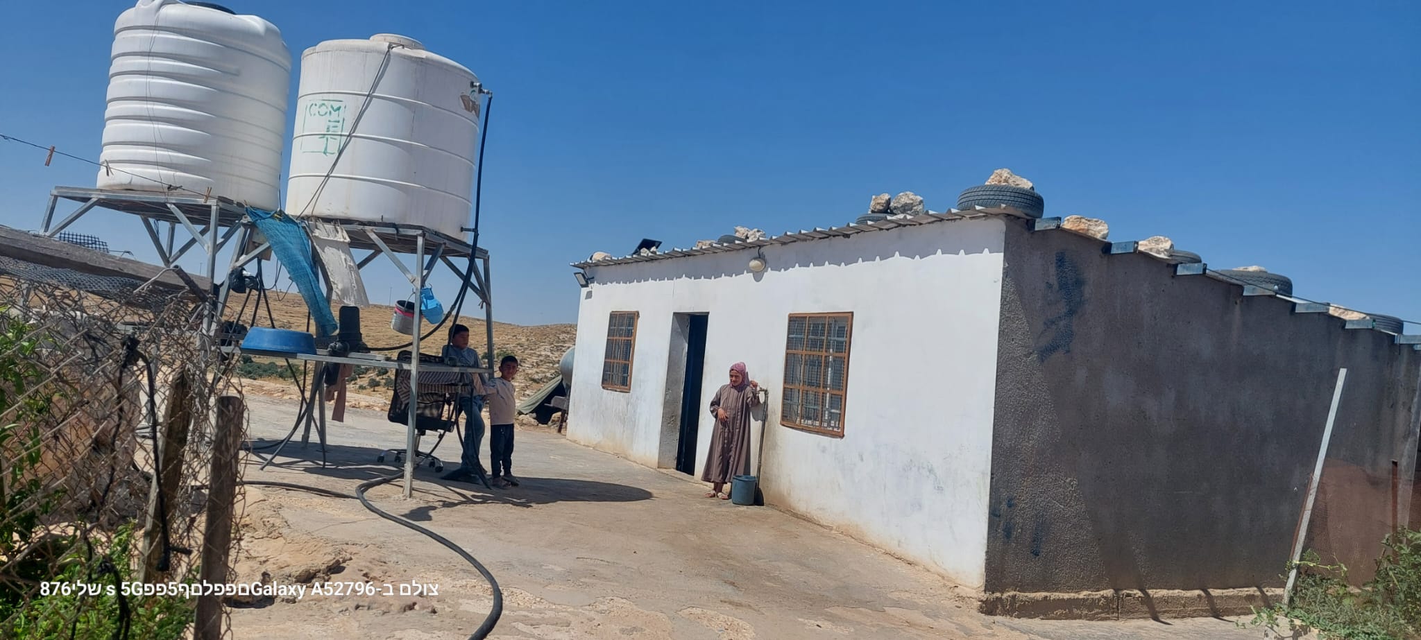
On the other side of road 317 is the entrance to Khirbet Radim, Abu Safi’s place of residence and birth. No more. He too was forced to leave following the threats and bullying of the settler Kaplan, who flourishes and shines today.
Ruins of what was until recently the home of Palestinians and now Israeli flags fly over them on road 317 in the Eshtaol area.
Further down the road new caravans and on a distant hill two figures are standing (on the skyline), it can be assumed that they are settlers because the Palestinians are not allowed to leave their villages. Maybe they are checking the area, on the way to a new settlement? We will follow this up.
We arrived at At-Tuwani. There is no checkpoint and no soldiers at the entrance, but the village itself looks like a ghost town. There is not a living soul in the streets and the place looks deserted. Even animals are not seen or heard in the village alleys, not to mention children’s voices.
We arrived following a phone call from Bassel to Muhammad and a video he sent showing settlers wearing uniforms bursting into the village school. It is seen in the video that they arrive in a vehicle without identification plates.
Bassel says that in the last month, since the fighting in Gaza began, the settlers usually arrive with an ATV or Jeep, wearing military uniforms, but from many years of acquaintance with them he is able to recognize them. At seven in the morning, Jacob Dalia’s son from the Lucifer farm arrived at the school accompanied by the army to look for Palestinian flags and cameras that the residents put up to record the settlers. The head of the At-Tuwani Council, Muhammad Muhammad Ar-Rabai, took a picture of them and called the army to complain, but there they told him that there are no soldiers in At-Tuwani now. When the settlers heard that the army was on their way, they tried to escape, but the residents prevented them from doing so until the army arrived and expelled the settlers.
Apparently, there is now a new policy and both the army and the police arrive faster when they are called, this compared to the situation about a month ago, when settlers shot his nephew who is still hospitalized and the police did not come.
Four or five people from volunteer organizations are now in At-Tuwani.
The entire space between Ma’on and At-Tuwani farms is closed, and the residents cannot reach their olive groves to harvest their crop.
Two soldiers stand in the area between the village and Maon preventing the people of At-Tuwani from reaching their plots of land.
Bassel says that the soldiers “see only with one eye – the eye of the settlers”. He also said that many buses now arrive in the settlements. They can only reach Yatta on foot. On leaving At-Tuwani we saw that the entrance to Yatta was closed with barbed wire and mounds of dirt. A car trying to go around the dirt mound got stuck.
Back on Route 60, Israeli flags occupied the hills.
A-Tuwani
See all reports for this place-
A-Tuwani
The locals came to a-Tuwani during the 20th century from the village of Yatta. They settled in abandoned ruins, utilizing the arable land, pastures for grazing sheep and the abundance of natural caves for habitation. The residents who settled in the caves came from families who could not purchase land for houses in the mother villages, as well as shepherds who did not have enough land to graze. They were joined by clan members who quarreled with other families in the mother locality.
Some of the residents today live in concrete buildings built above the caves. In the area of the village are several water cisterns and an ancient water well called 'Ein a-Tuwani. Local residents are forced to buy water in containers and transport them through many road blocks to the village. With the help of international organizations, an electrical system was installed in the village. In the late 90s of the 20tTh century, an elementary school was established in the serving several small villages in the area.
In 2004, MachsomWatch began visiting and reporting from the Khirbet Tuwani cave village, which suffers badly from the settlers of nearby outposts, and especially from the extremist Ma'on outpost. . The settlers contaminate cisterns, poison the flocks and uproot trees.Particularly notable is the harassment of children from the surrounding villages on their way to school in a-Tuwani, so much so that military escort of children is required to separate them from the attackers (this was arranged following an initiative of the organization's members). In the past year, the escort has been without the vital presence of overseas volunteers.
Near a-Tuwani there are several families who have returned to the caves due to the incessant demolitions of the civil administration (as there is a total construction ban in all of area C). Destroyed are not only residential and agricultural buildings, but also water pipes, machinery. Even water cisterns are clogged up. a-Tuwani residents have created an association for non-violent demolition protests, but in the past year the army’s harsh harassment and settler violence have intensified and escalated. The incident of the small generator confiscation, which left a young man paralyzed, is one of many examples - any legitimate protection of property rights leads to violence and even shootings by the army and the civil administration.
Updated April 2022
 Michal TsadikJun-21-2026Sha'ab al-Butum - the residential complex of the Najjar family
-
Meitar checkpoint / Sansana
See all reports for this place-
Meitar Checkpoint / Sansana The checkpoint is located on the Green Line and serves as a border crossing between Israel and the West Bank. It is managed by the Border Crossing Authority of the Defense Ministry. It is comprised of sections for the transfer of goods as well as a vehicle checkpoint (intended for holders of blue identity cards, foreign nationals or diplomats and international organizations). Passing of Palestinians is prohibited, except for those with entry permits to Israel. Palestinians are permitted to cross on foot only. The crossing has a DCO / DCL / DCL / DCL (District Coordination Office), a customs unit, supervision, and a police unit. In the last year, a breach has been opened in the fence, not far from the crossing. This breach is known to all, including the army. There does not appear to be any interest in blocking it, probably as it permits needed Palestinian workers without the bureaucratic permits to get to work in Israel. Food stalls and a parking area economy have been created, but incidents of violent abuse by border police have also been recorded. Updated April 2022
-
South Hebron Hills
See all reports for this place-
South Hebron Hills
South Hebron Hills is a large area in the West Bank's southern part.
Yatta is a major city in this area: right in the border zone between the fertile region of Hebron and its surroundings and the desert of the Hebron Hills. Yatta has about 64,000 inhabitants.
The surrounding villages are called Masafer Yatta (Yatta's daughter villages). Their inhabitants subsist on livestock and agriculture. Agriculture is possible only in small plots, especially near streams. Most of the area consists of rocky terraces.Since the beginning of the 1980s, many settlements have been established on the agricultural land cultivated by the Palestinians in the South Hebron Hills region: Carmel, Maon, Susia, Masadot Yehuda, Othniel, and more. Since the settlements were established and Palestinians cultivation areas have been reduced; the residents of the South Hebron Hills have been suffering from harassment by the settlers. Attempts to evict and demolish houses have continued, along with withholding water and electricity. The military and police usually refrain from intervening in violent incidents between settlers and Palestinians do not enforce the law when it comes to the investigation of extensive violent Jewish settlers. The harassment in the South Hebron Hills includes attacking and attempting to burn residential tents, harassing dogs, harming herds, and preventing access to pastures.
There are several checkpoints in the South Hebron Hills, on Routes 317 and 60. In most of them, no military presence is apparent, but rather an array of pillboxes monitor the villages. Roadblocks are frequently set up according to the settlers and the army's needs. These are located at the Zif Junction, the Dura-al Fawwar crossing, and the Sheep Junction at the southern entrance to Hebron.
Updated April 2022
Michal TsadikJun-21-2026Sha'ab al-Butum - the residential complex of the Najjar family
-
Zanuta
See all reports for this place-
Zanuta was a small rural Palestinian locality until its demolition. It was situated in the space around the town Dahariya in the South Hebron Hills, about a ten-minute ride from Meitar Checkpoint. There are documented remains of a large Byzantine settlement in the area. Since the Ottoman (Turkish Empire) period (1516-1917) Zanuta was documented as a locality of shepherds and farmers who live in the remains of the ancient structures and the residential caves near them.
Two individual ranches of colonists were created next to Zanuta: Meitarim (of the colonist Yinon Levi) to the east, and Yehudah (of the colonist Elyashiv Nachum) to the north. Endless attacks, harassments and attempt to chase away the Zanuta villagers have originated in these two outposts.
Until the expulsion, four families lived in the village: A-Samama, Al-Tel, Al Batat, and Al-Qaisia. Farming constituted their main economic activity and employed most of the villagers. The total area of the village is about 12,000 dunams, of which about 3,000 are tended, mostly with field crops.
This village has never had a master plan that would legitimize construction permits. The Civil Administration claimed it was too small and the distance to the next town, Dahariya, too great. For this reason, the Israeli authorities pressured the villagers to leave. The colonists did the job for them.
-