Bethlehem (300), Walaja, Jerusalem, Sheikh Sa'ad
Sheikh Sa'ad, the southern American Road and a stop in the area designated for a settlement west of Tzur Baher, Checkpoint 300 (Bethlehem) on the Palestinian side, Wallaja.
Sheikh Sa'ad and the southern American Road
The neighborhood is separated from its mother-neighborhood of Jabal Mukaber by a huge wall with a tall concertina wire addition. The children are on winter leave until tomorrow, and the school road leading to the checkpoint is empty. It has been refurbished in recent months, the slope has been reduced, and it has been slightly widened and a traffic circle has been added. The checkpoint is almost empty as well. We met a cute young teacher who lives in the neighborhood, and teaches physics and mathematics in Beit Hanina at the other end of Jerusalem. She is on her last day off, says that now there are no problems at the checkpoint and she goes out to spend time and make arrangements in Jerusalem - she is one of the lucky ones with a blue certificate.
*** From an "Ir Amim'' document we learned that a plan for the construction of a new large police station at the northwestern end of Jabal Mukaber is being discussed this week. The new station will also include a Border Police base, interrogation and detention rooms and other large area control facilities. The new station site was originally intended for the construction of public buildings for the benefit of the Palestinian neighborhood. In the area to be evacuated due to the relocation of the existing police base, two hotels are planned that are part of the developing Nof Zion settlement. It turns out that the entire maneuver for moving the police base is directly intended for the development of the settlement ***
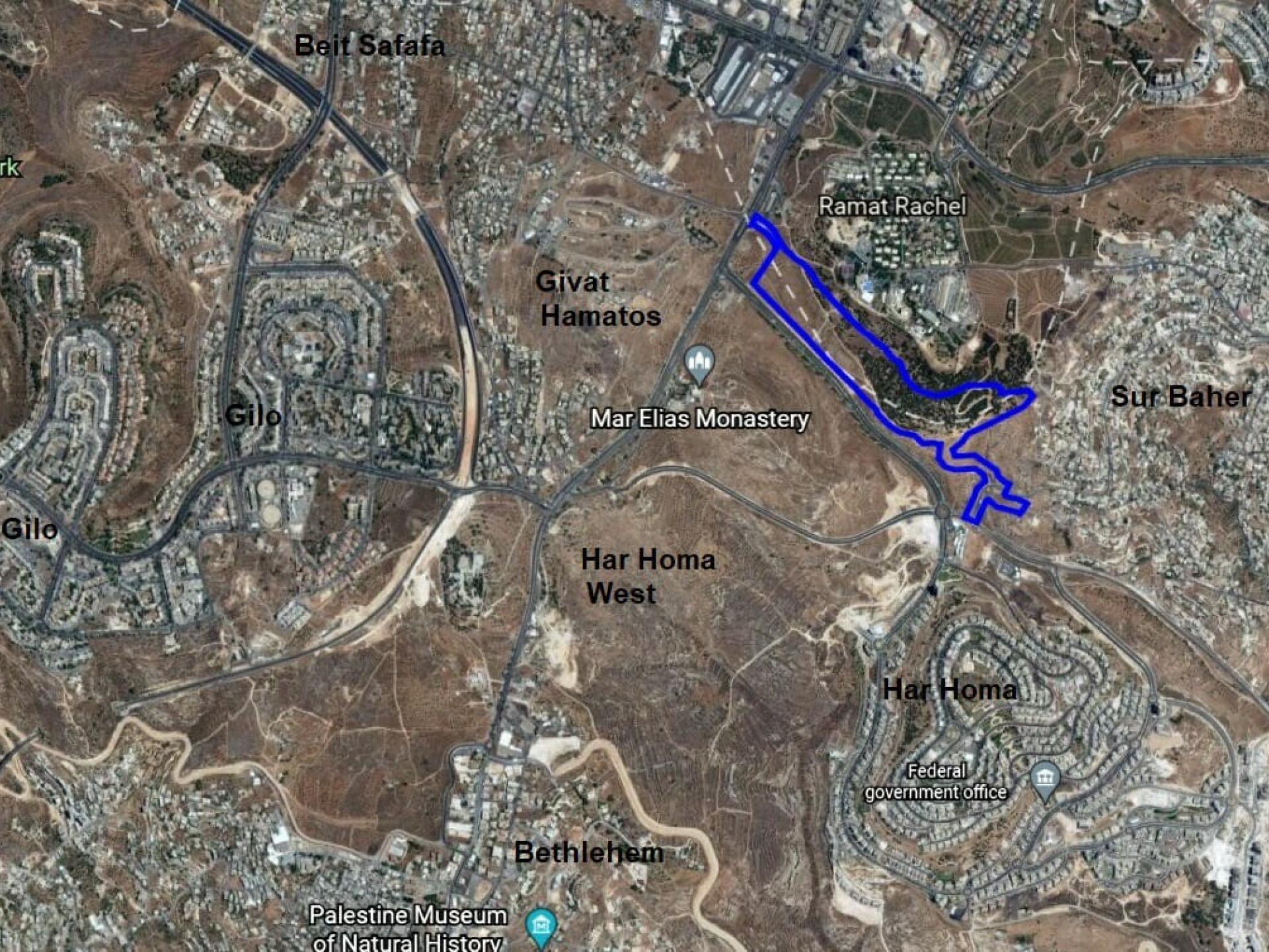
Archeological excavation in the area intended for the expansion of Road 398 and for the settlement that will connect Har Homa with the Givat Hamatos settlement that has been approved.
We drive on the new southern American Road (quite empty) and turn onto Route 398 towards the outskirts of Jabal Mukaber when we spot, opposite Har Homa, a fence with a sign "Area belonging to the Jerusalem Municipality" surrounding an area adjacent to the road. We go up to see: According to the archeologist in charge - there is a rescue excavation there for the purpose of "widening the road". She knows no more than that, but pleased to have found pot shards from different periods there. The religious overseer does not take his eyes off the excavation ...
*** It is no coincidence that we learned that a new neighborhood / settlement is planned that will connect the Har Homa neighborhood with the Givat Hamatos neighborhood that was abruptly approved in the late Trump / Bibi days. The goal is clear: to close part of the ring around southern Jerusalem enroute to Bethlehem (map attached, area surrounded by a purple line).
The practice of starting "infrastructure" work in the field before the approval of a plan in procedures for building a new settlement, is to establish facts on the ground and a way to hide early detection that can cause embarrassment, opposition, international condemnation and halting of the covert new plan. This practice is known from many places in Jerusalem. ***
Bethlehem checkpoint Palestinian side
We decided to visit the Palestinian side of the Bethlehem checkpoint, to understand what was happening at the crossing. The Israeli side is steeped in electronic positions for approving permits and facial recognition - there are more than 8 such positions on the Israeli side. When we stand there, most of the time everything flows, and there is a heavy presence of Border Police, police and sometimes a DCO representative. The troubles and problems in the passage area itself are brought to our attention only after the fact.
So why do the passers-by testify that it is so crowded and difficult to pass through the checkpoint in the mornings, why are those passing injured at the checkpoint during rush hour, and why did Kav LaOved and other organizations file a petition against the conduct at this checkpoint? (By the way, the petition was rejected "temporarily" until COVID passes ...).
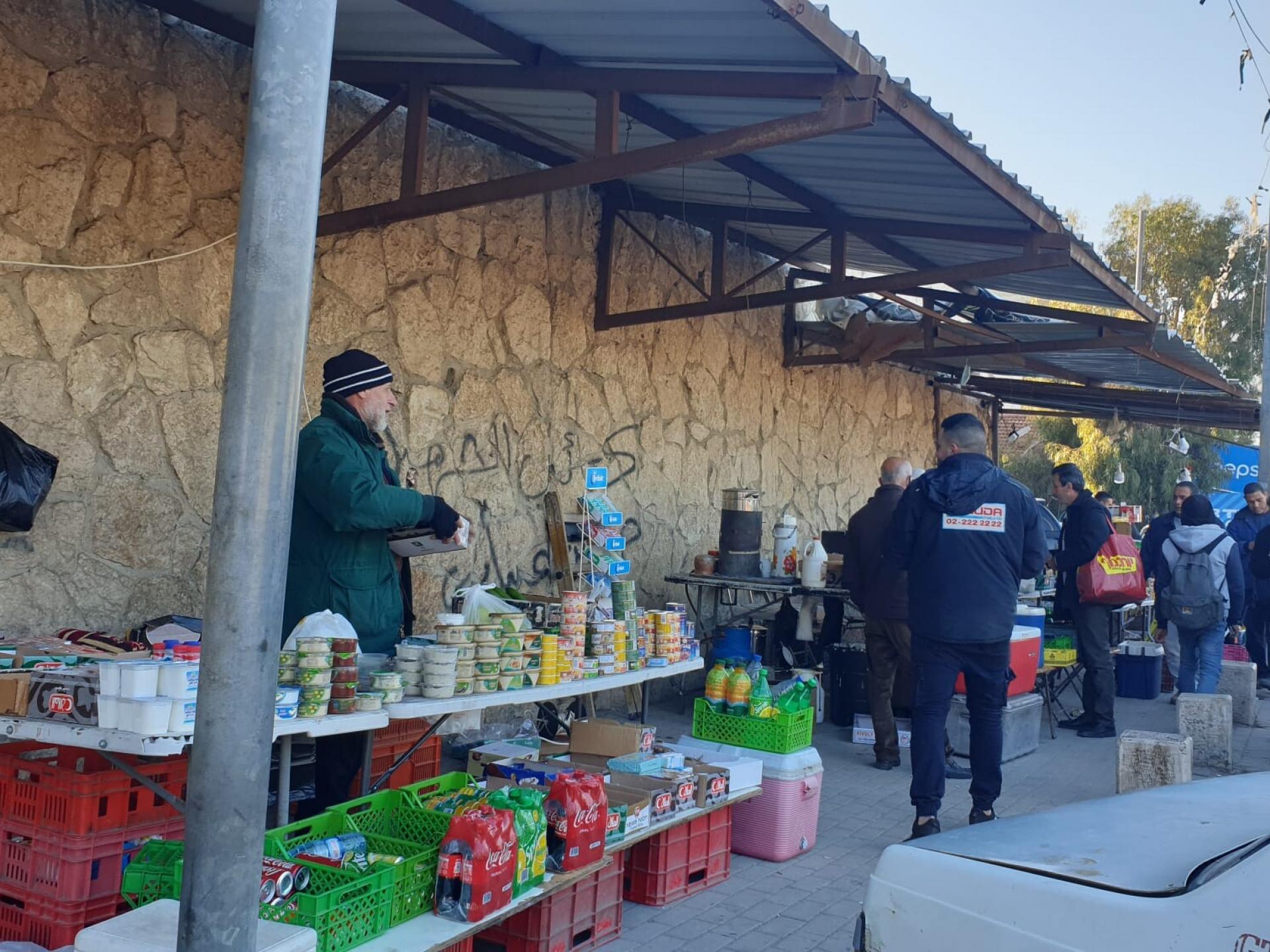
On the Palestinian side there is a small market with food, preserves, objects and tools necessary for those who forgot to bring from home, and opposite also a charcoal stove of Za’athar pitas and of course parking space for yellow taxis.
We spoke with a few drivers, heard what was happening in the mornings, then went up and photographed the scene. It was immediately apparent that the problem lies with the way the checkpoint is built: only one short ascent path turns 90 degrees into a small space with two turnstiles. These allow walking in a bisected corridor towards two more entrances to the magnetometer positions and object-checking positions. There are probably more than two such test stations inside, but the pressure is already created because of the first turnstiles into which people can enter only one by one. The queue created by the ascent and entrance to the carousels pushes together the thousands of people trying to get to work in Jerusalem in the morning, and the mess begins, the climbs over their heads, the suffering of those trying to make a living.
Those who try to pass through the humanitarian passage, which is located further up, on the side, are also pushed and blocked. We know that this passage only opens sometimes, and recieve constant complaints from the women and the sick. The absence of the Christian-Ecumenical volunteers, who would stand on the Palestinian side, help, document and make contact with us on the Israeli side, is acutely felt. They have not been to Israel for two years because of COVID.
*** As we drove along the separation wall on the exit road from the checkpoint towards Walaja, we photographed some of the pervasive graffiti. (Attached photos). A powerful drawing of a house-destroying bulldozer stands out, and even the inscription "Why did I enlist?" ***
Walaja
Once upon a time there was a Mount Gilo Field School. Today it is a large and well-established settlement that literally clings as a leach to the village of Walaja. With a wall in the middle of course. We went to see what was happening in the Jerusalem part of Walaja. Some of us had close and old acquaintances there. We found some ruined houses and a beautiful neighborhood that has dozens of demolition orders against it because of the lack of building permits. Building permits that can not be obtained at all. The legal proceedings have been exhausted and there is now tense silence. All the injustices already done are dwarfed at the moment: the passage by permit from the original village is on the ridge opposite here; the division of the village between Jerusalem and the territory under Palestinian management; The blockade of Ein Haniya, the spring garden and the pools, barring the villagers who used to celebrate there; The agricultural areas beyond the fence. Waiting to see what tomorrow brings.
*** On the way back to Jerusalem, huge queues to Emek Refaim Garden, where there are COVID tests. Kamal says those last in line will arrive tomorrow ... ***