
‘Anabta, ‘Awarta, ‘Azzun ‘Atma, Beit Furik, Huwwara, Irtah (Sha’ar Efrayim), Jubara (Kafriat), Za’tara (Tapuah), Thu 9.8.12, Afternoon
Translator: Hanna K.
A hot day during the Ramadan month.
14:40 Irtah CP – Thursday in Palestine is like our Friday, and especially during the Ramadan month. The workmen now return home earlier than usual. They go through the gate and are not being checked in the rooms.
We are told that the checks in the mornings "are sometimes good, sometimes not".
14:55 Jabara CP – Here the guards are still soldiers and not civilians working for a security company.
15:10 Anabta CP – we didn't see any soldiers at the new CP which is splendidly built. (!!!)
15:15 a military truck comes towards us on road no. 57, near the Jit intersection. When looking westwards it is impossible not to see the massive building at the Kedumin settlement.
15:20 The construction of an elaborate night illumination for part of road no. 60 has been completed. All o f I t is designated only to lighten the way for the inhabitants of the Gilad ranch settlement.
On the same road no. 60, towards us comes a military tender, followed by another.
15:28 Huwwara CP – There is a soldier at the guard tower opposite the hitch-hikers station at the way out from the Beraha settlement, there is another soldier sitting at the station itself, at the entrance to this settlement. Another soldiers is at the guard tower at the CP itself.
15:38 Beit Furik CP – we saw no soldiers at the CP.
15:42 Awarta CP – the yellow arm is still shut. There is no possibility to pass from here to Nablus.
16:26 A bit before the Za'tara/Tapuah CP – the blue police checks a Palestinian vehicle.
16:30 Za'tara/Tapuah CP – two soldiers sit in the shade. They do not check. There is no load. New banners intended for the settlers hang on the CP fence. A military vehicle arrives towards us with high lights after we passed the CP, and is followed by another.
16:50- Azzun Atma CP – There are no workmen waiting in the queue on their way home.
'Anabta CP
See all reports for this place-
'Anabta CP
The checkpoint is located south of the village of 'Anabta, at the intersection of Road 60 (leading to Nablus at the entrance to Area A), with Road (57, 557, 5576) facing west towards the Einav settlement and the checkpoint at the exit from the West Bank - Figs checkpoint. Until 2010 we used to watch the intersection and report the long columns created due to a slow inspection of the vehicles in both directions.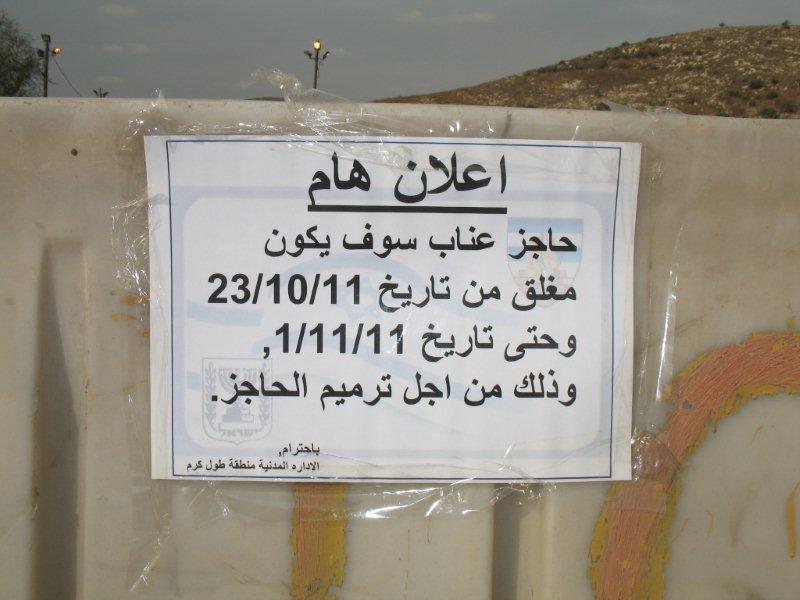 Oct-28-2011Anabta checkpoint 24.10.11
-
'Awarta
See all reports for this place-
Awarta, an internal checkpoint in the heart of the West Bank, is located east of the Hawara checkpoint, at the junction of Roads 555 (which was forbidden for Palestinian traffic in this area) and the entrance road to Nablus. It was one of the four checkpoints that surrounded Nablus until 2009. We used to watch it at Huwwara shifts because it was the only one where goods could be transferred to and from Nablus, using the back-to-back method. It was operated by the army, from 06:00 to 20:00. Until 2009.
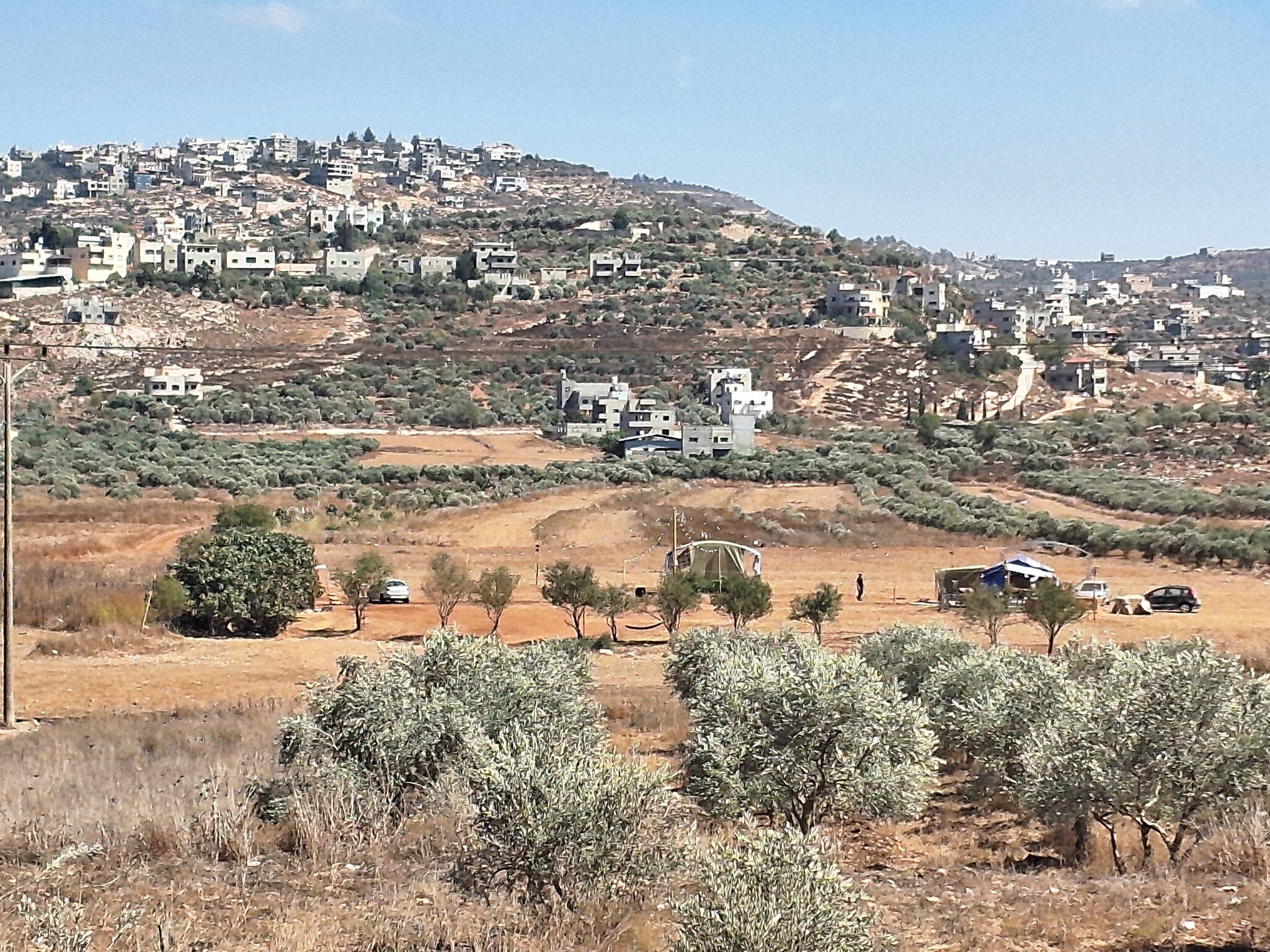 Ronit Dahan-RamatiSep-10-2026Awarta. Outpost below the town
-
'Azzun 'Atma
See all reports for this place-
'Azzun 'Atma
A Palestinian village of about 1,800 residents. The settlement of Sha'arei Tikva was established on its land adjacent to it, and the settlement of Oranit was established on its agricultural lands. By 2013, the separation fence had passed through the village and a checkpoint staffed by the army allowed the residents to cross from side to side. After building a massive wall surrounding the village and some of its agricultural lands, the residents went daily for five years to their lands that remained in the Seam Zone through the Oranit agricultural checkpoint (4). Since 2018 it has only opened during the olive harvest and the farmers have to pass daily at the Beit Amin / Abu Salman checkpoint (1447), about 3 kilometers north.From a report from March 24, 2021: "The farmers from Beit Amin and Azon Atma are happy that since February 21 the Oranit checkpoint .is going to be open 3 times a day, The farmers are really developing the place."
Report from July 14, 2024: "Ornit checkpoint is closed . The Beit Amin/Abu Salman agricultural checkpoint is closed (there is no contact with the military to check if it opens rarely), the Ezbat Jaloud checkpoint was opened once a day before the war.
Updated for July 2024
 Apr-11-2019Azoun: The main entrance to village blocked now for several weeks
-
Beit Furik checkpoint
See all reports for this place-
One of the three internal checkpoints that closed on the city of Nablus - Beit Furik to the east, Hawara to the south, Beit Iba to the west. The checkpoint is located at the junction of Roads 557 (an apartheid road that was forbidden for Palestinians), leading to the Itamar and Alon Morea settlements and Road 5487. The checkpoint was established in 2001 for pedestrians and vehicles; The opening hours were short and the transition was slow and very problematic.Allegedly, the checkpoint is intended to monitor the movement to and from Nablus of the residents of Beit Furik and Beit Dajan, being the only opening outside their villages. Since May 2009 the checkpoint is open 24 hours a day, the military presence is limited, vehicles can pass through it without inspections, except for random inspections. (Updated April 2010)
-
Huwwara
See all reports for this place-
The Huwwara checkpoint is an internal checkpoint south of the city of Nablus, at the intersection of Roads 60 and 5077 (between the settlements of Bracha and Itamar). This checkpoint was one of the four permanent checkpoints that closed on Nablus (Beit Furik and Awarta checkpoints to the east and the Beit Iba checkpoint to the west). It was a pedestrian-only barrier. As MachsomWatch volunteers, we watched therre since 2001 two shifts a day - morning and noon, the thousands of Palestinians leaving Nablus and waiting for hours in queues to reach anywhere else in the West Bank, from the other side of the checkpoint the destination could only be reached by public transport. In early June 2009, as part of the easing of Palestinian traffic in the West Bank, the checkpoint was opened to vehicular traffic. The passage was free, with occasional military presence in the guard tower. Also, there were vehicle inspections from time to time. Since the massacre on 7.10.2023, the checkpoint has been closed to Palestinians.
On February 26, 2023, about 400 settlers attacked the town's residents for 5 hours and set fire to property, such as houses and cars. Disturbances occurred in response to a shooting of two Jewish residents of Har Bracha by a Palestinian Terrorist. The soldiers stationed in the town did not prevent the arson and rescued Palestinian families from their homes only after they were set on fire. No one was punished and Finance Minister Smotrich stated that "the State of Israel should wipe out Hawara." Left and center organizations organized solidarity demonstrations and support actions for the residents of Hawara.Hawara continued to be in the headlines in all the months that followed: more pogroms by the settlers, attacks by Palestinians and a massive presence of the army in the town. It amounted to a de facto curfew of commerce and life in the center of the city. On October 5, 2023, MK Zvi established a Sukkah in the center of Hawara and hundreds of settlers backed the army blocked the main road and held prayers in the heart of the town all night and the next day. On Saturday, October 7, 23 The "Swords of Iron" war began with an attack by Hamas on settlements surrounding Gaza in the face of a poor presence of the IDF. Much criticism has been made of the withdrawal of military forces from the area surrounding Gaza and their placement in the West Bank, and in the Hawara and Samaria region in particular, as a shield for the settlers who were taking over and rioting.
On November 12, 2023, the first section of the Hawara bypass road intended for Israeli traffic only was opened. In this way, the settlers can bypass the road that goes through the center of Hawara, which is the main artery for traffic from the Nablus area to Ramallah and the south of the West Bank. For the construction of the road, the Civil Administration expropriated 406 dunams of private land belonging to Palestinians from the nearby villages. The settlers are not satisfied with this at the moment, and demand to also travel through Hawara itself in order to demonstrate presence and control.(updated November 2023)
.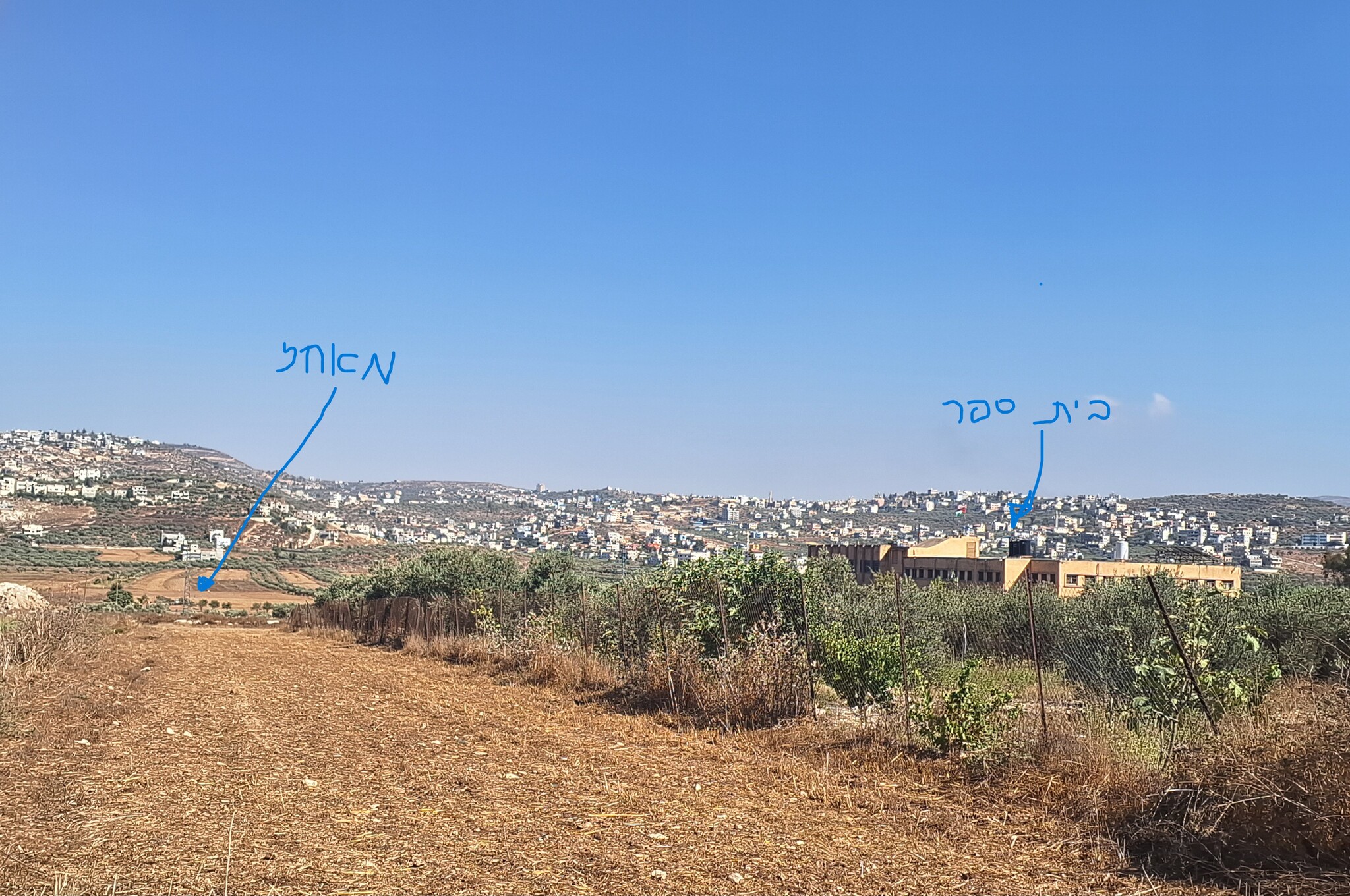 Ronit Dahan-RamatiAug-24-2026Huwara: The school on the outskirts of town and an outpost hidden among the trees
-
Irtah (Sha'ar Efrayim)
See all reports for this place-
The checkpoint is for Palestinians only. It is the main barrier to the passage of workers from the northern West Bank to Israel. Workers with a permit to work in Israel and also for trade (with appropriate permissions), medicine, and visiting prisoners. One can cross the checkpoint only on foot. The checkpoint is located north of Road 557 and south of Tulkarm. Operated by a civil security company, opening hours: between 4:00 and 19:00 on weekdays. As members of Machsom Watch, we began our shifts to this location in 2007. We arrived before it opened at 4 in the morning and report since, on the harsh conditions and the long and crowded queues of workers. The workers who pass by continue their journey by transportation to work throughout Israel. In the first period of its activity, about 3,000 and then 5,000 people passed through this checkpoint every day. Due to the small number of checking points and arbitrary delays for long periods of time in the "rooms", workers feared losing their transportation. Hence workers leave their homes at 2:30 at night to be among the first. Today, 15,000 pass and the transition is faster. Workers are still leaving their homes very early to get past the checkpoint at 7 p.m. In an adjacent compound, there is a terminal for the transfer of goods on a commercial scale, using the back-to-back method.
-
Jubara (Kafriat)
See all reports for this place-
The Jabra checkpoint was on Road 557, south of Tulkarm, on the side of the Figs Pass, which is located within the Palestinian Authority (a few kilometers east of the Green Line), and serves as an entry barrier from the territories to Israel. The checkpoint to the village of Jubara, which until 2013 was in the seam area, blocked and surrounded by a fence, was intended for the passage of the family members of the house next to the checkpoint, and also for the MachsomWatch volunteers (with special permission only), on their way to checkpoint 753. on the other side of the village. The soldiers supervising the "fig crossing" also supervised the crossing at this checkpoint, in our shifts we often waited a long time until the key was found and the gate opened. The checkpoint was abolished and became part of the separation fence that was moved west following the High Court.
-
Za'tara (Tapuah)
See all reports for this place-
Za'tara (Tapuah) Za'tara is an internal checkpoint in the heart of the West Bank, at the intersection of Road 60 and Road 505 (Trans-Samaria), east of the Tapuah settlement. This checkpoint is the "border" marked by the IDF between the north and south of the West Bank, in accordance with the policy of separation between the two parts of the West Bank that has been in place since December 2005. At the Za'tara checkpoint, there are separate routes for Israelis and Palestinians. In the route for Israelis, there are no inspections and the route for Palestinians inspects. The queue lengthens and shortens suits. The checkpoint is open 24 hours a day. The checkpoint is partially staffed and the people who pass through it are checked at random.
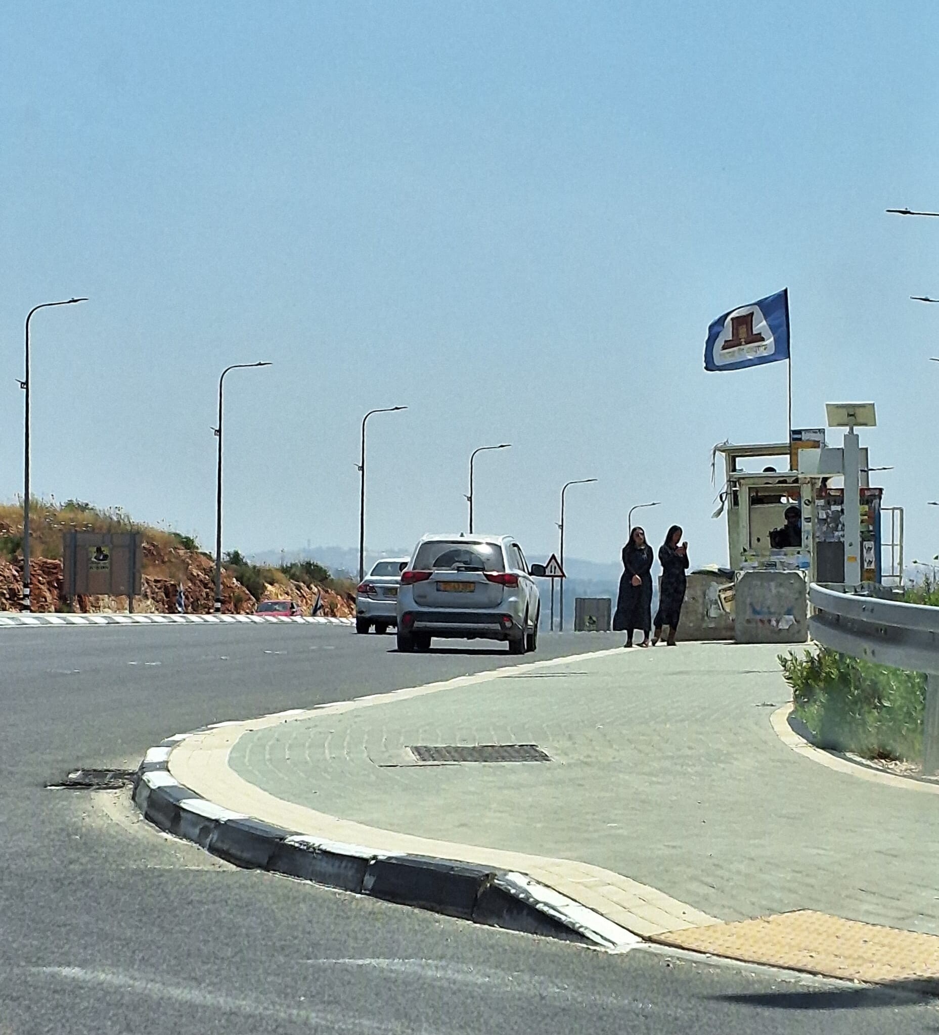 Ronit Dahan-RamatiJun-9-2026Za'atara (Tapuach Junction). The Temple Flag Above a Station
-
