
‘Azzun, ‘Izbet alTabib, Falamiya, Habla, Jayyus, Kifl Harith, Kufr Jammal
Orientation and local meetings
09:30 We left Kfar Saba in Nadim's car. Goal: to show the new and recent members a little of the way of life in the West Bank.
We went on highway #5, by way of the Shomron passage, where no one paid attention to us, naturally. We spoke about the wide and well-lit road built for the settlements, on which the Palestinians have only been allowed to drive for the past few years, and even that only up to a certain point, from which they can return to their villages.
We enter Kifl Haris, whose name seems to be a confusion of the word for dog (kalev), or perhaps the settlers decided this was the source of the name and sanctified a grave which was in the midst of the village, next to the local Moslem cemetery. I found out in Wikipedia that the building called "Nebi Tul Kifl" in Arabic, where the word Kifl is the name Kaleb ben Yafunah in Arabic. It is also thought to be the burial place of Yehoshua Bin Nun, which is called Timnat Serach in the bible. The settlers decided that Timnat Serach is Kifl Haris.
A group of local workers were there, building the fence for the Moslem cemetery, in order to prevent desecration of the graves by the settlers, who come to celebrate memorials at night around the "sacred" grave, while the army protects them, of course.
One of the workers spoke Hebrew, and he told us what has been happening to the residents of the village: The soldiers come in the evening and warn them about the visit to the grave which is about to take place; afterwards, they stand in several places in the village and watch the events. The celebrants arrive at night, singing and beating loud drums, which wake everyone in the village. This goes on until 05:00 several times a month. Considering the mess and garbage around the grave, as well as in the Moslem cemetery, there seems to have been considerable celebrating going on.
There is a sign there from Shomron Army Unit and the Ministry of Religions, announcing the "sacredness" of the place.
We continue over to highway #55, a wide and well kept road which leads, by way of Nofim and Yakir, to Emmanuel. The scenery is lovely, and the massive buildings of the settlements ruin it. At the entrance to ‘Azzun, there is a military jeep. We felt hungry, so we ate falafel in a friendly place (5 NIS, including drinks)….
At Jayyus they have moved the fence, and the Falamya Gate is no longer visible, but the earth is disturbed for several kilometers and it will take years before it will be suitable again for agriculture. One of the six wells of Jayyus was returned to their jurisdiction, and a pipe conveys water to the village. Perhaps this is an end to the contaminated drinking water from the well in ‘Azzun?
In Jamal village we visited the local grocery store and were welcomed with tea and coffee. We were able to chat with the owner in Hebrew. He is careful not to express any radical opinions, and only says that it is difficult for them to witness what the air force is doing in Gaza. He also says that they don't feel any difference between the state of affairs before and after the war.
We passed through Izbat Tabib, the school was very busy and the protest tent is still standing.
At the Habla Gate everything was as usual. The gate was wide open and the inspection was fast. In the afternoon, there wasn't much action.
14:15 We departed.
—
'Azzun
See all reports for this place-
Azoun (updated February 2019)
A Palestinian town situated in Area B (under civil Palestinian control and Israeli security control),
on road 5 between Nablus and Qalqiliya, east of Nabi Elias village. The inhabitants are allowed to construct and improve infrastructures. The Separation Fence has confiscated lands belonging to the town's people. In 2018 olive tree groves owned by one of its inhabitants were confiscated for the sake of paving a road to bypass Nabi Elias. Azoun population numbers 13,000, its economic state dire. Its infrastructures are poor, neglect and poverty rampant. In the meantime, the town council has completed paving an internal road for the inhabitants' welfare.
Because of its proximity to the Jewish settler-colony of Karnei Shomron and its outposts, the town suffers the intense presence of the Israeli army, especially at nighttime: soldiers enter homes, arrest suspects, trash the house and sometimes ruin it, as they do in numerous places in the West Bank. At times a checkpoint closes the entrance to the town, so no one can come in or get out.
-
'Izbet a-Tabib
See all reports for this place-
'Izbet a-Tabib
-
Falamiya
See all reports for this placeHabla
See all reports for this place-
Habla CP (1393)
The Habla checkpoint (1393) was established on the lands of the residents of Qalqilya, on the short road that
connected it for centuries to the nearby town of Habla. The separation barrier intersects this road twice and cut off the residents of Qalqilya from their lands in the seam zone.(between the fence and the green line).
There is a passage under Road 55 that connects Qalqilya to the sabotage This agricultural barrier is used by the farmers and nursery owners established along Road 55 from the Green Line and on both sides of the kurkar road leading to the checkpoint.
This agricultural checkpoint serves the residents of Arab a-Ramadin al-Janoubi (detached from the West Bank), who pass through it to the West Bank and back to their homes. The opening hours (3 times a day) of this agricultural checkpoint are longer than usual, about an hour (recently shortened to 45 minutes), and are coordinated with the transportation hours of a-Ramadin children studying in the occupied in the West Bank.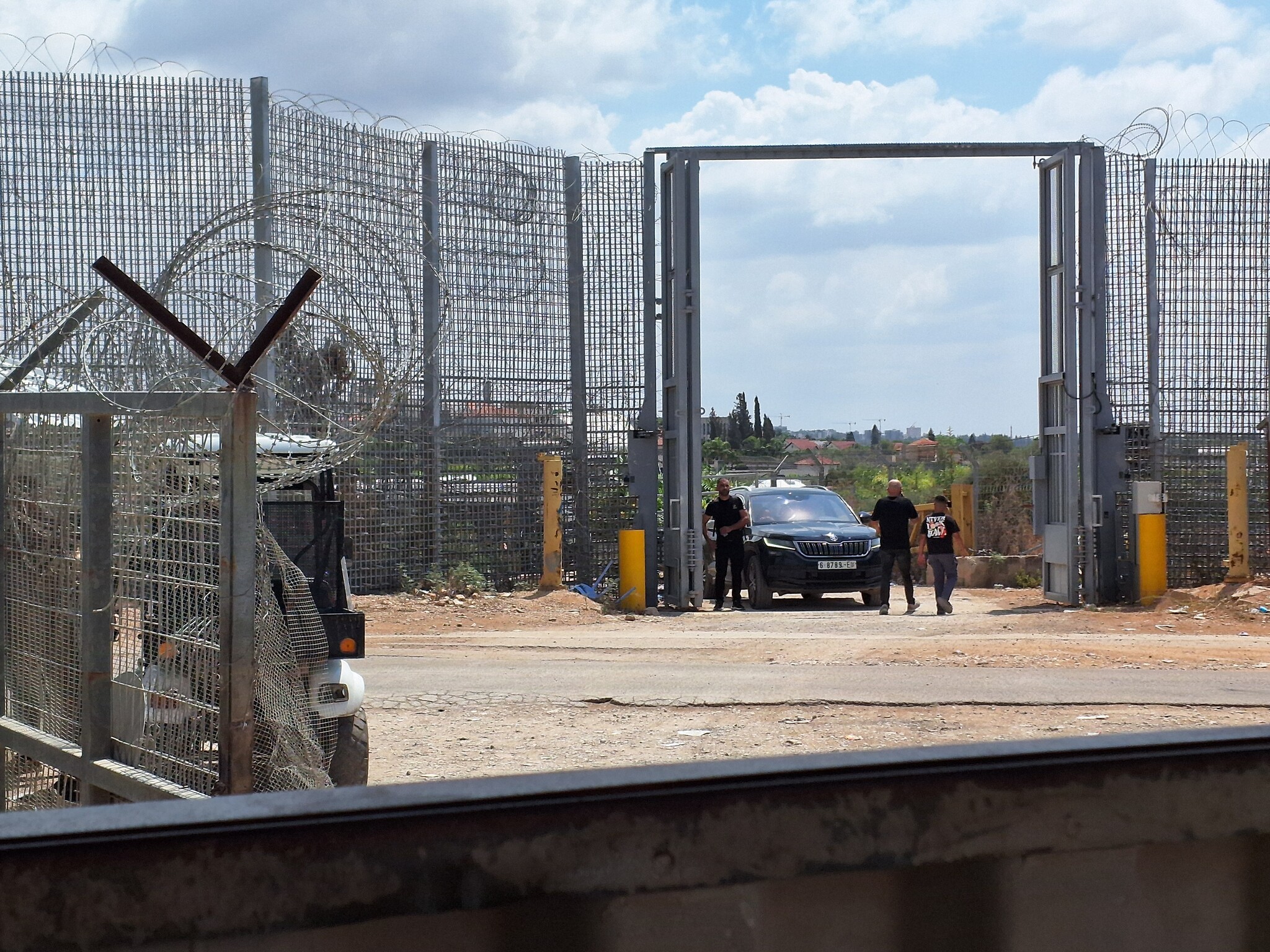 Ronit Dahan-RamatiAug-31-2026Habla. The gate is open
-
Jayyus North (935)
See all reports for this placeKifl Harith
See all reports for this place-
Kifl Harith
This is a Palestinian located north-west of the settler-colony town of Ariel, 18 kilometers south of the city of Nablus. It numbers 3, 206 inhabitants, as of 2007. 42% of the village lands lie in Area B, and 58% in Area C. In 1978, some hundreds of dunams of the village’s farmland was sequestered in order to found the settler-colony of Ariel – in total 5,184 dunams from the Palestinian communities of Salfit, Iscaqa, Marda, and Kifl Harith. Dozens of square kilometers were also confiscated for paving road no. 5 as well as road 505 and their buffer zones, and the Israeli electricity company’s power station. Over the years the village has suffered harassment by sometimes-armed settler-colonists, even casualties. In 1968 the army’s rabbinate ruled the maqam site Nabi Yanoun (sanctified grave of the Prophet Yanoun) is in fact the tomb of Joshua, Son of Nun. Another structure in the village, named Nabi Tul Kifl by the Palestinians, has been identified by the Israeli authorities as to the tomb of Caleb, Son of Yefuneh. These sites are located in the heart of the village, near the mosque, and at times of Jewish religious festivities and pilgrimages, the center of the village is illuminated by projectors and thousands of Jews arrive, protected by hundreds of Israeli soldiers. During such a period, a night curfew is imposed on the village and the villagers are forced to stay shut inside their homes.
-
Kufr Jammal
See all reports for this place-
Kufr Jammal This village, rising about 200 meters over sea level, is located about 14 kilometers south of Tul Karm town and about 17 kilometers from the Mediterranean Sea. The families living there since the mid-18th century number about 3,000 persons at present. The village has lost thousands of dunams of its northern and western lands due to the construction of the Separation Barrier, leaving the lands themselves behind the barrier. After the Israeli Supreme Court ruling in 2011, the barrier was moved to the west and many farmlands were returned to their owners. It is a quiet village, its relations with the nearby settler-colony of Sal’it are favorable, and many of the villagers work in the colony’s industrial plants. Farmers cross the agricultural checkpoint close to this settler-colony in order to tend their fields unhampered. However, there are numerous acts of harassment and disorder taking place when the village farmers cross the other agricultural checkpoints: gates do not open at hours suitable to the farmers’ needs, and for a short period of time only; the Civil Administration usually prevents all kinds of crops except olives; tractors and other farm equipment are forbidden entry; only a single permit is issued per family, and occasionally such permits are confiscated and their re-issue is delayed – the common excuse is usually “security reasons”. How do the villagers make their living? Holders of work permits inside Israel travel at 3 a.m. to Eyal Checkpoint near Qalqiliya town in order to make it on time to their workplace at Sal’it (close to their village) and elsewhere. Owners of vegetable patches who hold permits are allowed to reach their fields beyond the Separation Barrier through the distant Falamiya Checkpoint. Importantly, fields returned to the village show amazing improvement intending, irrigation and farming variety – and instead of the neglected olive tree groves that were accessible only to holders of transit permits through agricultural checkpoints usually closed, farming has now flourished. (updated Jan 2021)
-
